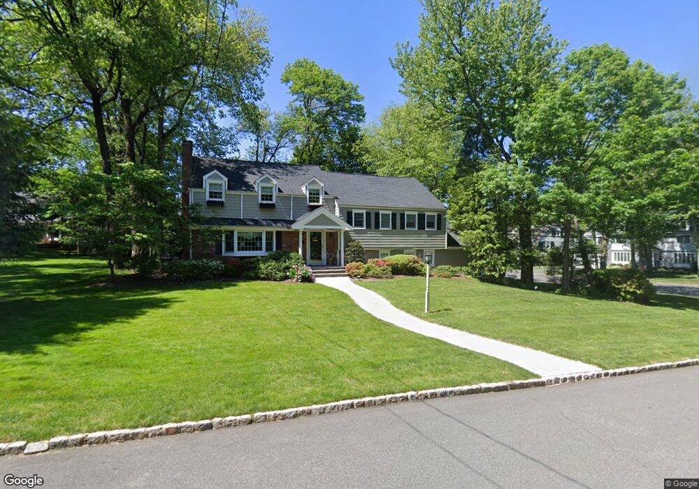
82 Acorn Dr Summit, NJ 07901
Estimated Value: $1,159,514 - $1,827,000
Studio
--
Bath
2,891
Sq Ft
$498/Sq Ft
Est. Value
About This Home
This home is located at 82 Acorn Dr, Summit, NJ 07901 and is currently estimated at $1,438,879, approximately $497 per square foot. 82 Acorn Dr is a home located in Union County with nearby schools including New Providence High School, The Academy of Our Lady of Peace, and Oak Knoll School of the Holy Child.
Ownership History
Date
Name
Owned For
Owner Type
Purchase Details
Closed on
Jun 8, 2012
Sold by
Loewy Manfred
Bought by
Damarr Properties Llc
Current Estimated Value
Purchase Details
Closed on
May 31, 2012
Sold by
Sann Perry and Sann Diane
Bought by
Sann Diane
Purchase Details
Closed on
Jul 20, 1996
Sold by
Sucic Nicholas R and Sucic Judith A
Bought by
Sann Perry and Sann Diane
Home Financials for this Owner
Home Financials are based on the most recent Mortgage that was taken out on this home.
Original Mortgage
$100,000
Interest Rate
7.31%
Create a Home Valuation Report for This Property
The Home Valuation Report is an in-depth analysis detailing your home's value as well as a comparison with similar homes in the area
Home Values in the Area
Average Home Value in this Area
Purchase History
| Date | Buyer | Sale Price | Title Company |
|---|---|---|---|
| Damarr Properties Llc | -- | None Available | |
| Sann Diane | -- | None Available | |
| Sann Perry | $325,500 | -- |
Source: Public Records
Mortgage History
| Date | Status | Borrower | Loan Amount |
|---|---|---|---|
| Previous Owner | Sann Perry | $100,000 |
Source: Public Records
Tax History
| Year | Tax Paid | Tax Assessment Tax Assessment Total Assessment is a certain percentage of the fair market value that is determined by local assessors to be the total taxable value of land and additions on the property. | Land | Improvement |
|---|---|---|---|---|
| 2025 | $19,352 | $374,900 | $157,600 | $217,300 |
| 2024 | $18,771 | $374,900 | $157,600 | $217,300 |
| 2023 | $18,771 | $374,900 | $157,600 | $217,300 |
| 2022 | $18,513 | $374,900 | $157,600 | $217,300 |
| 2021 | $18,378 | $374,900 | $157,600 | $217,300 |
| 2020 | $18,370 | $374,900 | $157,600 | $217,300 |
| 2019 | $18,258 | $374,900 | $157,600 | $217,300 |
| 2018 | $18,164 | $374,900 | $157,600 | $217,300 |
| 2017 | $17,868 | $374,900 | $157,600 | $217,300 |
| 2016 | $17,617 | $374,900 | $157,600 | $217,300 |
| 2015 | $17,373 | $374,900 | $157,600 | $217,300 |
| 2014 | $17,110 | $374,900 | $157,600 | $217,300 |
Source: Public Records
Map
Nearby Homes
- 22 Brook Hollow Ln
- 78 Seven Oaks Dr
- 65 Seven Oaks Dr
- 157 Grant Ave
- 15 Alison Ct
- 49 the Fellsway
- 17 Badgley Dr
- 25 Division Ave
- 71 Dale Dr
- 34 Grant Ave
- 27 Grant Ave
- 26 E 3rd St
- 21 Woodruff Ct
- 63 Gallinson Dr
- 50 Livingston Ave
- 61 Oakwood Dr
- 39 Gallinson Dr
- 48 Marion Ave
- 709 Springfield Ave Unit One
- 709 Springfield Ave Unit 4
- 83 Acorn Dr
- 165 Stoneridge Rd
- 75 Acorn Dr
- 153 Stoneridge Rd
- 64 Acorn Dr
- 125 Central Ave
- 63 Old Oak Dr
- 133 Central Ave
- 110 Central Ave
- 147 Stoneridge Rd
- 54 Acorn Dr
- 141 Central Ave
- 162 Stoneridge Rd
- 152 Stoneridge Rd
- 107 Central Ave
- 51 Old Oak Dr
- 48 Acorn Dr
- 32 Brook Hollow Ln
- 38 Brook Hollow Ln
- 5 Woodcrest Dr
Your Personal Tour Guide
Ask me questions while you tour the home.