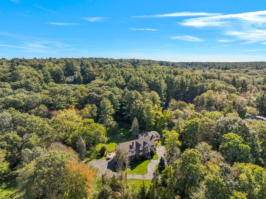
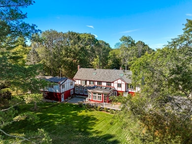
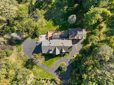
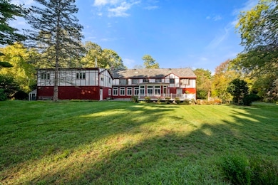
82 Buckskin Dr Weston, MA 02493
Estimated payment $20,781/month
Highlights
- Golf Course Community
- 4.35 Acre Lot
- Property is near public transit
- Country Elementary School Rated A+
- Deck
- Living Room with Fireplace
About This Home
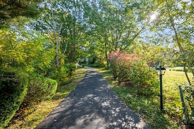
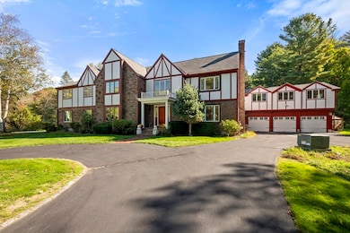
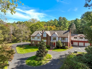
The largest lot in the prestigious Weston Estates—spanning 4.35 acres—is available for the first time in over forty years! This incredibly rare offering combines the three intangible elements that matter most: lot, location, and privacy. Lovingly maintained by the same family for over four decades, this stately English Tudor blends timeless character with extraordinary potential. High ceilings, open concept and expansive windows bathe the interiors in natural light, creating warm and inviting spaces throughout. Generous rooms and flexible areas make the home ideal for multigenerational living, multiple home offices, or a creative reimagining to suit today’s lifestyles. The sprawling grounds with bluestone patios further elevate the property, offering ample space to add outdoor amenities. For those who value privacy, space, and the opportunity to personalize, all within the exceptional Weston school district—82 Buckskin Drive stands as a truly rare opportunity you won't want to miss!
Home Details
Home Type
- Single Family
Est. Annual Taxes
- $28,012
Year Built
- Built in 1978
Lot Details
- 4.35 Acre Lot
- Wooded Lot
- Property is zoned RS
Parking
- 3 Car Attached Garage
- Driveway
- Open Parking
- Off-Street Parking
Home Design
- Tudor Architecture
- Shingle Roof
- Concrete Perimeter Foundation
Interior Spaces
- Wet Bar
- Vaulted Ceiling
- Living Room with Fireplace
- 2 Fireplaces
- Home Office
- Bonus Room
- Finished Basement
- Interior Basement Entry
Kitchen
- Range
- Microwave
- Dishwasher
- Kitchen Island
Flooring
- Wood
- Tile
Bedrooms and Bathrooms
- 5 Bedrooms
- Primary bedroom located on second floor
- Walk-In Closet
Laundry
- Dryer
- Washer
Outdoor Features
- Bulkhead
- Deck
- Patio
Location
- Property is near public transit
- Property is near schools
Schools
- Wps Elementary School
- WMS Middle School
- WHS High School
Utilities
- Central Air
- 5 Cooling Zones
- 5 Heating Zones
- Heating System Uses Natural Gas
- Baseboard Heating
- 200+ Amp Service
- Gas Water Heater
- Private Sewer
Listing and Financial Details
- Assessor Parcel Number M:030.0 L:0025 S:000.0,868143
Community Details
Overview
- No Home Owners Association
- Weston Estates Subdivision
- Near Conservation Area
Amenities
- Shops
Recreation
- Golf Course Community
- Community Pool
- Park
- Jogging Path
Map
Home Values in the Area
Average Home Value in this Area
Tax History
| Year | Tax Paid | Tax Assessment Tax Assessment Total Assessment is a certain percentage of the fair market value that is determined by local assessors to be the total taxable value of land and additions on the property. | Land | Improvement |
|---|---|---|---|---|
| 2025 | $28,012 | $2,523,600 | $1,384,100 | $1,139,500 |
| 2024 | $27,714 | $2,492,300 | $1,384,100 | $1,108,200 |
| 2023 | $28,287 | $2,389,100 | $1,384,100 | $1,005,000 |
| 2022 | $27,973 | $2,183,700 | $1,303,300 | $880,400 |
| 2021 | $4,193 | $2,086,700 | $1,248,100 | $838,600 |
| 2020 | $27,142 | $2,115,500 | $1,248,100 | $867,400 |
| 2019 | $7,934 | $2,124,800 | $1,248,100 | $876,700 |
| 2018 | $7,900 | $2,150,000 | $1,248,100 | $901,900 |
| 2017 | $3,645 | $2,253,400 | $1,248,100 | $1,005,300 |
| 2016 | $27,583 | $2,268,300 | $1,248,100 | $1,020,200 |
| 2015 | $27,060 | $2,203,600 | $1,198,300 | $1,005,300 |
Property History
| Date | Event | Price | List to Sale | Price per Sq Ft |
|---|---|---|---|---|
| 10/08/2025 10/08/25 | For Sale | $3,500,000 | -- | $453 / Sq Ft |
Purchase History
| Date | Type | Sale Price | Title Company |
|---|---|---|---|
| Deed | $587,000 | -- |
Mortgage History
| Date | Status | Loan Amount | Loan Type |
|---|---|---|---|
| Open | $275,000 | No Value Available | |
| Closed | $335,000 | No Value Available | |
| Closed | $203,000 | No Value Available |
Source: MLS Property Information Network (MLS PIN)
MLS Number: 73441052
APN: WEST-000030-000025
Disclaimer: Certain information contained herein is derived from information provided by parties other than Homes.com. All information provided is deemed reliable, but is not guaranteed to be accurate and should be independently verified.
![]() The property listing data and information, or the Images, set forth herein were provided to MLS Property Information Network, Inc. from third party sources, including sellers, lessors and public records, and were compiled by MLS Property Information Network, Inc. The property listing data and information, and the Images, are for the personal, non-commercial use of consumers having a good faith interest in purchasing or leasing listed properties of the type displayed to them and may not be used for any purpose other than to identify prospective properties which such consumers may have a good faith interest in purchasing or leasing. MLS Property Information Network, Inc. and its subscribers disclaim any and all representations and warranties as to the accuracy of the property listing data and information, or as to the accuracy of any of the Images, set forth herein.
The property listing data and information, or the Images, set forth herein were provided to MLS Property Information Network, Inc. from third party sources, including sellers, lessors and public records, and were compiled by MLS Property Information Network, Inc. The property listing data and information, and the Images, are for the personal, non-commercial use of consumers having a good faith interest in purchasing or leasing listed properties of the type displayed to them and may not be used for any purpose other than to identify prospective properties which such consumers may have a good faith interest in purchasing or leasing. MLS Property Information Network, Inc. and its subscribers disclaim any and all representations and warranties as to the accuracy of the property listing data and information, or as to the accuracy of any of the Images, set forth herein.
- 42 Westerly Rd
- 72 Love Ln
- 19 Old Connecticut Path
- 23 Covered Bridge Ln
- 180 Highland St
- 1 Pine Summit Cir
- 10 Hayward Rd
- 12 Astra
- 23 Pine Summit Cir Unit 23
- 31 White Rd
- 1 Astra Unit 1
- 14 Lundy Ln
- 1004 Wisteria Way
- 11 Wadsworth Ln Unit 11
- 7 Fox Hollow
- 8 Fox Hollow
- 9 Christina
- 606 Wisteria Way
- 1605 Wisteria Way
- 1601 Wisteria Way
- 4 Elliston Rd
- 73 Jericho Rd Unit 73
- 188 Country Dr
- 423 Concord Rd
- 72 Church St Unit B
- 373 Commonwealth Rd
- 490 Boston Post Rd
- 42 Willard Rd
- 186 Main St Unit 1
- 186 Main St Unit 2
- 2 Marigold Ave
- 1 Sunnyside Ave
- 9 Gennaro Cir
- 17 Lexington St
- 1449 Main St
- 410 Conant Rd
- 11 Nantucket Rd
- 11 Nantucket Rd
- 751 South St
- 137 Virginia Rd
