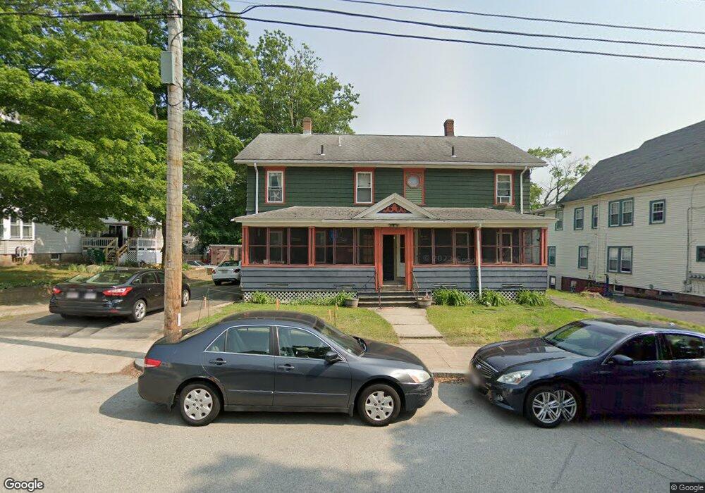
82 Cottage St Unit 84 Whitinsville, MA 01588
Estimated Value: $484,835 - $630,000
6
Beds
2
Baths
3,569
Sq Ft
$160/Sq Ft
Est. Value
About This Home
This home is located at 82 Cottage St Unit 84, Whitinsville, MA 01588 and is currently estimated at $571,709, approximately $160 per square foot. 82 Cottage St Unit 84 is a home located in Worcester County with nearby schools including Northbridge Elementary School, Northbridge Middle School, and Northbridge High School.
Ownership History
Date
Name
Owned For
Owner Type
Purchase Details
Closed on
Oct 3, 1997
Sold by
Larochelle Dennis J and Larochelle Maureen P
Bought by
Lachance Richard R
Current Estimated Value
Home Financials for this Owner
Home Financials are based on the most recent Mortgage that was taken out on this home.
Original Mortgage
$112,500
Interest Rate
7.41%
Mortgage Type
Purchase Money Mortgage
Create a Home Valuation Report for This Property
The Home Valuation Report is an in-depth analysis detailing your home's value as well as a comparison with similar homes in the area
Home Values in the Area
Average Home Value in this Area
Purchase History
| Date | Buyer | Sale Price | Title Company |
|---|---|---|---|
| Lachance Richard R | $118,500 | -- | |
| Lachance Richard R | $118,500 | -- |
Source: Public Records
Mortgage History
| Date | Status | Borrower | Loan Amount |
|---|---|---|---|
| Open | Lachance Richard R | $170,000 | |
| Closed | Lachance Richard R | $155,000 | |
| Closed | Lachance Richard R | $112,500 |
Source: Public Records
Tax History Compared to Growth
Tax History
| Year | Tax Paid | Tax Assessment Tax Assessment Total Assessment is a certain percentage of the fair market value that is determined by local assessors to be the total taxable value of land and additions on the property. | Land | Improvement |
|---|---|---|---|---|
| 2025 | $4,716 | $400,000 | $126,800 | $273,200 |
| 2024 | $4,288 | $354,700 | $126,800 | $227,900 |
| 2023 | $4,139 | $319,400 | $120,100 | $199,300 |
| 2022 | $3,871 | $281,100 | $92,400 | $188,700 |
| 2021 | $3,537 | $244,100 | $88,000 | $156,100 |
| 2020 | $3,190 | $230,500 | $88,000 | $142,500 |
| 2019 | $2,724 | $210,000 | $88,000 | $122,000 |
| 2018 | $2,664 | $205,900 | $83,900 | $122,000 |
| 2017 | $2,694 | $199,100 | $83,900 | $115,200 |
| 2016 | $2,514 | $182,800 | $72,000 | $110,800 |
| 2015 | $2,439 | $182,300 | $72,000 | $110,300 |
| 2014 | $2,331 | $175,800 | $72,000 | $103,800 |
Source: Public Records
Map
Nearby Homes
- 18 East St Unit 24
- 128 Linwood Ave
- 1 Elm St
- 90 Nathaniel Dr
- 21 Granite St
- 9 Banning Dr
- 28-30 Haringa Ave
- 13 Crestwood Cir Unit 48
- 33 Crestwood Cir Unit 45
- 35 Crestwood Cir Unit 44
- 140 Rolling Ridge Dr Unit 78
- 39 Crestwood Cir Unit 42
- 46 Rebecca Rd
- 192 Rebecca Rd
- 159 Rolling Ridge Dr Unit 85
- 169 Rolling Ridge Dr Unit 97
- 237 Heritage Dr Unit 237
- 831 Providence Rd Unit 837
- 86 Kingsnorth St
- 235 Rivulet St
- 80 Cottage St
- 88 Cottage St
- 81 Cottage St
- 85 Cottage St
- 89 Cottage St Unit 91
- 75 Cottage St
- 93 Cottage St
- 93R Cottage St
- 96 Cottage St
- 93 Cottage St
- 113 Church St
- 67 Cottage St Unit 69
- 100 Cottage St Unit 102
- 99 Cottage St Unit 99
- 97 Cottage St Unit 99
- 97 Cottage St Unit 2
- 89 Church St
- 63 Cottage St Unit 65
- 106 Cottage St
- 95 Church St