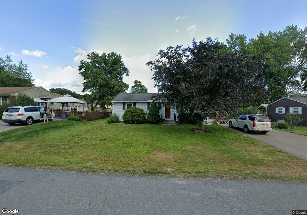
82 Edison Dr Ludlow, MA 01056
Estimated Value: $253,000 - $340,000
3
Beds
1
Bath
960
Sq Ft
$305/Sq Ft
Est. Value
About This Home
This home is located at 82 Edison Dr, Ludlow, MA 01056 and is currently estimated at $293,073, approximately $305 per square foot. 82 Edison Dr is a home located in Hampden County with nearby schools including East Street Elementary School, Chapin Street Elementary School, and Paul R. Baird Middle School.
Ownership History
Date
Name
Owned For
Owner Type
Purchase Details
Closed on
May 10, 2021
Sold by
Lamotte David G and Batista Kim M
Bought by
Hill Daniel A and Hill Amanda M
Current Estimated Value
Home Financials for this Owner
Home Financials are based on the most recent Mortgage that was taken out on this home.
Original Mortgage
$214,000
Outstanding Balance
$192,797
Interest Rate
3%
Mortgage Type
Purchase Money Mortgage
Estimated Equity
$100,276
Create a Home Valuation Report for This Property
The Home Valuation Report is an in-depth analysis detailing your home's value as well as a comparison with similar homes in the area
Home Values in the Area
Average Home Value in this Area
Purchase History
| Date | Buyer | Sale Price | Title Company |
|---|---|---|---|
| Hill Daniel A | $223,000 | None Available | |
| Hill Daniel A | $223,000 | None Available |
Source: Public Records
Mortgage History
| Date | Status | Borrower | Loan Amount |
|---|---|---|---|
| Open | Hill Daniel A | $214,000 | |
| Closed | Hill Daniel A | $214,000 |
Source: Public Records
Tax History
| Year | Tax Paid | Tax Assessment Tax Assessment Total Assessment is a certain percentage of the fair market value that is determined by local assessors to be the total taxable value of land and additions on the property. | Land | Improvement |
|---|---|---|---|---|
| 2025 | $4,870 | $280,700 | $85,100 | $195,600 |
| 2024 | $4,646 | $256,800 | $85,100 | $171,700 |
| 2023 | $4,435 | $227,300 | $77,900 | $149,400 |
| 2022 | $3,962 | $198,200 | $71,400 | $126,800 |
| 2021 | $3,474 | $164,800 | $71,400 | $93,400 |
| 2020 | $3,361 | $163,000 | $70,300 | $92,700 |
| 2019 | $3,141 | $158,500 | $69,700 | $88,800 |
| 2018 | $2,973 | $156,400 | $69,700 | $86,700 |
| 2017 | $2,783 | $150,200 | $61,500 | $88,700 |
| 2016 | $2,638 | $145,500 | $60,200 | $85,300 |
| 2015 | $2,498 | $144,500 | $59,600 | $84,900 |
Source: Public Records
Map
Nearby Homes
- 229 Miller St Unit F-13
- 229 Miller St Unit C-1
- 229 Miller St Unit E-6
- 229 Miller St Unit 3 G
- 25 Dale St
- 308 Miller St Unit 79
- 308 Miller St Unit 78
- 308 Miller St Unit 6
- 80 Elizabeth Dr
- 16 Maple St
- 4 Hillcrest Dr
- 36 Maple St
- 35 Lake Dr
- 37 Balsam Hill Rd
- Lot 28 Tower Rd
- 22 Balsam Hill Rd
- 46 Washington Rd
- 1172 East St
- 44 Balsam Hill Rd
- 143 James St
Your Personal Tour Guide
Ask me questions while you tour the home.