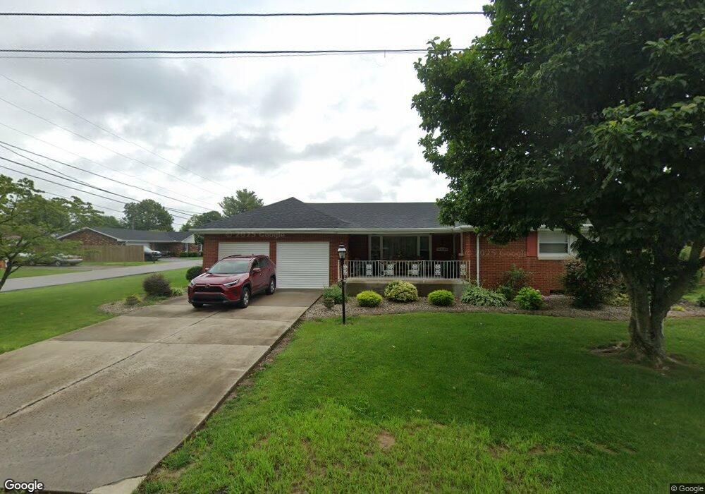
82 Malibu Dr Owingsville, KY 40360
Estimated Value: $149,000 - $229,000
4
Beds
3
Baths
1,998
Sq Ft
$96/Sq Ft
Est. Value
About This Home
This home is located at 82 Malibu Dr, Owingsville, KY 40360 and is currently estimated at $192,206, approximately $96 per square foot. 82 Malibu Dr is a home located in Bath County with nearby schools including Owingsville Elementary School, Bath County Middle School, and Bath County High School.
Ownership History
Date
Name
Owned For
Owner Type
Purchase Details
Closed on
May 1, 2023
Sold by
Otis Janice M
Bought by
Conn Jeffery A and Conn Sandra Mae
Current Estimated Value
Purchase Details
Closed on
Jun 8, 2010
Sold by
Rogan J James
Bought by
Otis Jeffrey L
Home Financials for this Owner
Home Financials are based on the most recent Mortgage that was taken out on this home.
Original Mortgage
$91,135
Interest Rate
4.97%
Mortgage Type
FHA
Create a Home Valuation Report for This Property
The Home Valuation Report is an in-depth analysis detailing your home's value as well as a comparison with similar homes in the area
Home Values in the Area
Average Home Value in this Area
Purchase History
| Date | Buyer | Sale Price | Title Company |
|---|---|---|---|
| Conn Jeffery A | $108,500 | None Listed On Document | |
| Conn Jeffery A | $108,500 | None Listed On Document | |
| Otis Jeffrey L | $90,000 | None Available |
Source: Public Records
Mortgage History
| Date | Status | Borrower | Loan Amount |
|---|---|---|---|
| Previous Owner | Otis Jeffrey L | $91,135 |
Source: Public Records
Tax History Compared to Growth
Tax History
| Year | Tax Paid | Tax Assessment Tax Assessment Total Assessment is a certain percentage of the fair market value that is determined by local assessors to be the total taxable value of land and additions on the property. | Land | Improvement |
|---|---|---|---|---|
| 2024 | $1,075 | $92,000 | $0 | $0 |
| 2023 | $1,065 | $92,000 | $0 | $0 |
| 2022 | $1,004 | $92,000 | $0 | $0 |
| 2021 | $991 | $92,000 | $0 | $0 |
| 2020 | $964 | $90,000 | $0 | $0 |
| 2019 | $1,027 | $90,000 | $0 | $0 |
| 2018 | $1,036 | $90,000 | $0 | $0 |
| 2017 | -- | $90,000 | $0 | $0 |
| 2015 | -- | $90,000 | $0 | $0 |
| 2013 | -- | $90,000 | $8,000 | $82,000 |
Source: Public Records
Map
Nearby Homes
- 215 Cecil Ave
- 73 Water Plant Rd
- 4252 Kentucky 36
- 463 E High St
- 611 E High St
- 620 E High St
- 753 E Highway 60
- 935 E Highway 60
- 2647 Kentucky 36
- 1053 Shrout Rd
- 1039 Shrout Rd
- 983 Shrout Rd
- 4439 Kentucky 36
- 8590 Stulltown Rd
- 3751 Kendall Springs Rd
- 3795 Kendall Springs Rd
- 335 Jay Rd
- 313 Jay Rd
- 1162 Hart Pike
- 0 Powers Branch Rd Unit LotWP001 21944400