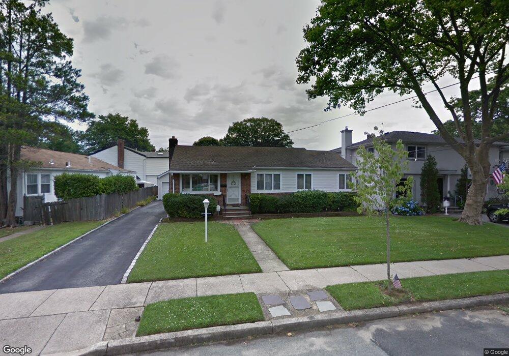
82 Mcintosh Ct Malverne, NY 11565
Estimated Value: $744,000 - $747,368
3
Beds
2
Baths
1,452
Sq Ft
$514/Sq Ft
Est. Value
About This Home
This home is located at 82 Mcintosh Ct, Malverne, NY 11565 and is currently estimated at $745,684, approximately $513 per square foot. 82 Mcintosh Ct is a home located in Nassau County with nearby schools including Grace Lutheran School and Our Lady of Lourdes School.
Ownership History
Date
Name
Owned For
Owner Type
Purchase Details
Closed on
Jun 15, 2021
Sold by
Ingenito Susan
Bought by
Amato Dennis J
Current Estimated Value
Home Financials for this Owner
Home Financials are based on the most recent Mortgage that was taken out on this home.
Original Mortgage
$455,840
Outstanding Balance
$412,706
Interest Rate
2.9%
Mortgage Type
FHA
Estimated Equity
$332,978
Purchase Details
Closed on
Mar 26, 1996
Sold by
Eisenstein Shirley
Bought by
Ingenito Susan
Create a Home Valuation Report for This Property
The Home Valuation Report is an in-depth analysis detailing your home's value as well as a comparison with similar homes in the area
Home Values in the Area
Average Home Value in this Area
Purchase History
| Date | Buyer | Sale Price | Title Company |
|---|---|---|---|
| Amato Dennis J | $560,000 | First American Title | |
| Ingenito Susan | $178,000 | -- |
Source: Public Records
Mortgage History
| Date | Status | Borrower | Loan Amount |
|---|---|---|---|
| Open | Amato Dennis J | $455,840 |
Source: Public Records
Tax History Compared to Growth
Tax History
| Year | Tax Paid | Tax Assessment Tax Assessment Total Assessment is a certain percentage of the fair market value that is determined by local assessors to be the total taxable value of land and additions on the property. | Land | Improvement |
|---|---|---|---|---|
| 2025 | $8,213 | $484 | $197 | $287 |
| 2024 | $1,017 | $448 | $190 | $258 |
| 2023 | $10,023 | $531 | $225 | $306 |
| 2022 | $10,023 | $531 | $225 | $306 |
| 2021 | $15,346 | $508 | $215 | $293 |
| 2020 | $22,765 | $963 | $601 | $362 |
| 2019 | $1,510 | $963 | $601 | $362 |
| 2018 | $1,477 | $963 | $0 | $0 |
| 2017 | $9,471 | $963 | $601 | $362 |
| 2016 | $10,863 | $963 | $601 | $362 |
| 2015 | $1,430 | $963 | $601 | $362 |
| 2014 | $1,430 | $963 | $601 | $362 |
| 2013 | $1,312 | $963 | $601 | $362 |
Source: Public Records
Map
Nearby Homes
- 56 Adair Ct
- 818 Palmetto Dr
- 163 Scarcliffe Dr
- 807 Cypress Dr
- 53 Maple St
- 10 Linden St
- 2 Derby Ct
- 70 Morris Ave
- 133 Nassau Ave
- 114 Nassau Ave
- 1096 Shelburne Dr
- 859 Franklin Ave
- 1027 Windermere Rd
- 100 Nassau Ave
- 1115 Agnes Ct
- 52 Legion Place
- 993 Ferngate Dr
- 1048 Windermere Rd
- 815 Franklin Ave Unit 4
- 1047 Windermere Rd