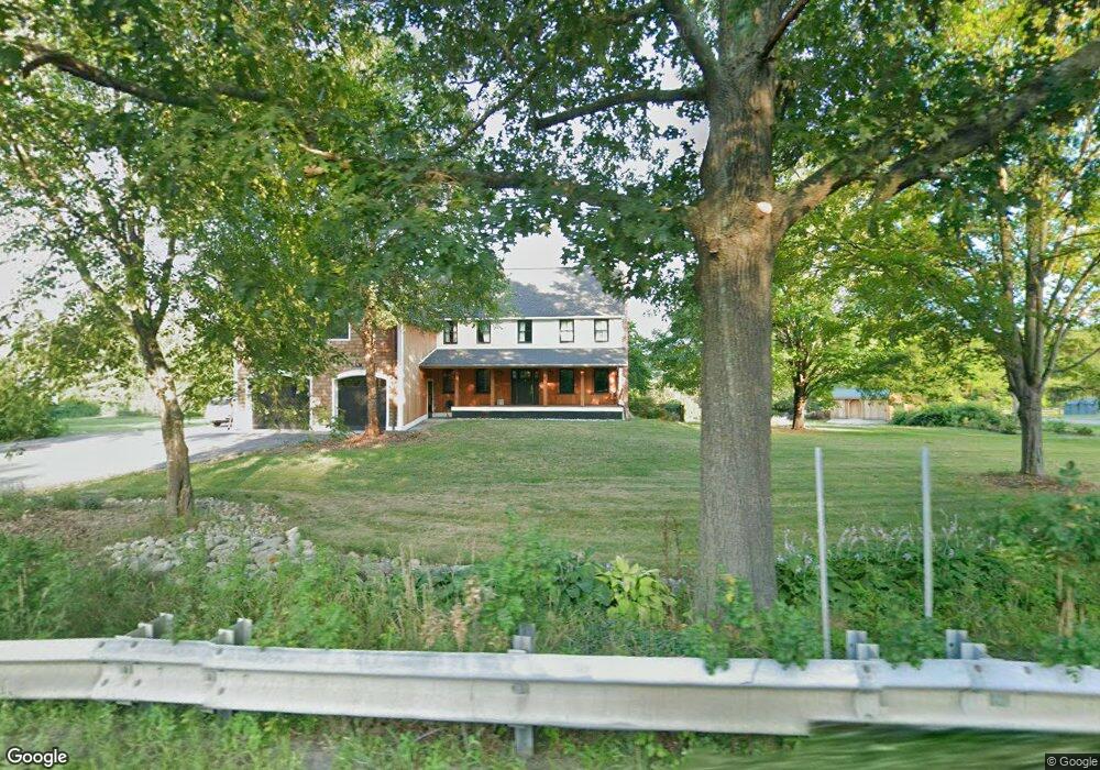
82 Powers Rd Westford, MA 01886
Estimated Value: $1,164,000 - $1,530,000
3
Beds
3
Baths
2,570
Sq Ft
$502/Sq Ft
Est. Value
About This Home
This home is located at 82 Powers Rd, Westford, MA 01886 and is currently estimated at $1,290,760, approximately $502 per square foot. 82 Powers Rd is a home located in Middlesex County with nearby schools including Col John Robinson, John A. Crisafulli Elementary School, and Blanchard Middle School.
Ownership History
Date
Name
Owned For
Owner Type
Purchase Details
Closed on
Aug 9, 2013
Sold by
Frank Orrin and Pearlmutter Nina L
Bought by
Miller Donald and Miller Catherine
Current Estimated Value
Home Financials for this Owner
Home Financials are based on the most recent Mortgage that was taken out on this home.
Original Mortgage
$424,000
Outstanding Balance
$316,067
Interest Rate
4.45%
Mortgage Type
New Conventional
Estimated Equity
$974,693
Purchase Details
Closed on
Sep 19, 1994
Sold by
Kindred Bros Inc
Bought by
Frink Orrin and Pearlmutter Nina
Create a Home Valuation Report for This Property
The Home Valuation Report is an in-depth analysis detailing your home's value as well as a comparison with similar homes in the area
Home Values in the Area
Average Home Value in this Area
Purchase History
| Date | Buyer | Sale Price | Title Company |
|---|---|---|---|
| Miller Donald | $530,000 | -- | |
| Frink Orrin | $286,300 | -- |
Source: Public Records
Mortgage History
| Date | Status | Borrower | Loan Amount |
|---|---|---|---|
| Open | Miller Donald | $424,000 | |
| Previous Owner | Frink Orrin | $365,000 | |
| Previous Owner | Frink Orrin | $300,000 | |
| Previous Owner | Frink Orrin | $270,000 |
Source: Public Records
Tax History Compared to Growth
Tax History
| Year | Tax Paid | Tax Assessment Tax Assessment Total Assessment is a certain percentage of the fair market value that is determined by local assessors to be the total taxable value of land and additions on the property. | Land | Improvement |
|---|---|---|---|---|
| 2025 | $15,023 | $1,115,300 | $315,000 | $800,300 |
| 2024 | $14,676 | $1,065,800 | $300,000 | $765,800 |
| 2023 | $14,412 | $976,400 | $285,800 | $690,600 |
| 2022 | $14,975 | $929,000 | $249,900 | $679,100 |
| 2021 | $10,392 | $624,500 | $249,900 | $374,600 |
| 2020 | $10,260 | $628,300 | $249,900 | $378,400 |
| 2019 | $9,560 | $577,300 | $225,400 | $351,900 |
| 2018 | $9,134 | $564,500 | $215,600 | $348,900 |
| 2017 | $8,753 | $533,400 | $215,600 | $317,800 |
| 2016 | $8,298 | $509,100 | $215,600 | $293,500 |
| 2015 | $8,286 | $510,200 | $215,600 | $294,600 |
| 2014 | $8,001 | $482,000 | $207,000 | $275,000 |
Source: Public Records
Map
Nearby Homes
- 84 Powers Rd
- 16 Fletcher Ln
- 18 Long Lake Rd
- 26 Long Lake Rd
- 35 Queen Rd
- 125 Concord Rd
- 254 Concord Rd Unit Lot 2A
- 601 Old Stone Brook
- 55 Jennifer St
- 12 Paula Beth St
- 405 Great Elm Way
- 91 Jimney Dr Unit 91
- 92 Jimney Dr
- 146 Tahattawan Rd
- 41 Flagg Rd
- 305 Harwood Ave
- 159 Skyline Dr Unit 159
- 49 Quarry Rd Unit 49
- 4 Omega Way
- 927 Main St