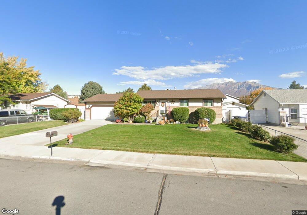
820 W 2100 N Provo, UT 84604
Riverside NeighborhoodEstimated Value: $492,000 - $529,000
3
Beds
5
Baths
1,160
Sq Ft
$437/Sq Ft
Est. Value
About This Home
This home is located at 820 W 2100 N, Provo, UT 84604 and is currently estimated at $506,494, approximately $436 per square foot. 820 W 2100 N is a home located in Utah County with nearby schools including Westridge Elementary School, Dixon Middle School, and Provo High School.
Ownership History
Date
Name
Owned For
Owner Type
Purchase Details
Closed on
Sep 24, 2018
Sold by
Johnson Connie
Bought by
Johnson Connie T and Connie Johnson Family Trust
Current Estimated Value
Home Financials for this Owner
Home Financials are based on the most recent Mortgage that was taken out on this home.
Original Mortgage
$75,000
Outstanding Balance
$65,270
Interest Rate
4.5%
Mortgage Type
Credit Line Revolving
Estimated Equity
$441,224
Purchase Details
Closed on
Feb 1, 2017
Sold by
Johnson Connie T
Bought by
Johnson Connie Gene and Connie Johnson Family Trust
Purchase Details
Closed on
Jan 26, 1998
Sold by
Johnson Thomas Allred
Bought by
Johnson Connie T
Home Financials for this Owner
Home Financials are based on the most recent Mortgage that was taken out on this home.
Original Mortgage
$90,000
Interest Rate
7.05%
Create a Home Valuation Report for This Property
The Home Valuation Report is an in-depth analysis detailing your home's value as well as a comparison with similar homes in the area
Home Values in the Area
Average Home Value in this Area
Purchase History
| Date | Buyer | Sale Price | Title Company |
|---|---|---|---|
| Johnson Connie T | -- | Pro Title And Escrow Inc | |
| Johnson Connie | -- | Pro Title & Escrow Inc | |
| Johnson Connie Gene | -- | None Available | |
| Johnson Connie T | -- | -- |
Source: Public Records
Mortgage History
| Date | Status | Borrower | Loan Amount |
|---|---|---|---|
| Open | Johnson Connie T | $75,000 | |
| Closed | Johnson Connie T | $90,000 |
Source: Public Records
Tax History Compared to Growth
Tax History
| Year | Tax Paid | Tax Assessment Tax Assessment Total Assessment is a certain percentage of the fair market value that is determined by local assessors to be the total taxable value of land and additions on the property. | Land | Improvement |
|---|---|---|---|---|
| 2025 | $2,462 | $280,995 | $172,200 | $338,700 |
| 2024 | $2,462 | $242,330 | $0 | $0 |
| 2023 | $2,392 | $232,155 | $0 | $0 |
| 2022 | $2,275 | $222,640 | $0 | $0 |
| 2021 | $1,727 | $294,700 | $109,300 | $185,400 |
| 2020 | $1,665 | $266,400 | $99,400 | $167,000 |
| 2019 | $1,559 | $259,300 | $92,300 | $167,000 |
| 2018 | $1,365 | $230,400 | $85,200 | $145,200 |
| 2017 | $1,325 | $122,815 | $0 | $0 |
| 2016 | $1,378 | $119,075 | $0 | $0 |
| 2015 | $1,341 | $117,150 | $0 | $0 |
| 2014 | $1,099 | $100,100 | $0 | $0 |
Source: Public Records
Map
Nearby Homes
- 819 W 2300 N
- 1009 W 2000 N
- 814 E 1740 S
- 1763 Willowbrook Dr Unit 4D1
- 1661 Willowbrook Dr
- 1685 Hickory Ln
- 696 E 1700 S
- 1927 Columbia Ln
- 1633 Woodland Dr
- 920 W Columbia Ln
- 691 E 1600 S
- 666 E 1600 S
- 720 E 1500 S
- 1559 N Riverside Ave Unit 4
- 493 E 2000 S
- 414 E 1834 S
- 1360 S Carterville Rd
- 444 1600 S Unit 1
- 1516 W 1970 N
- 1525 N 1250 W