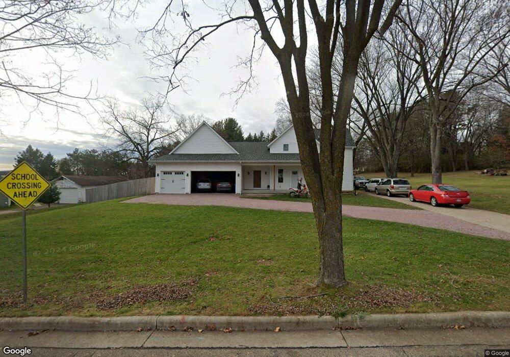
821 Connie Rd Baraboo, WI 53913
Estimated Value: $308,000 - $433,499
Studio
--
Bath
--
Sq Ft
2.19
Acres
About This Home
This home is located at 821 Connie Rd, Baraboo, WI 53913 and is currently estimated at $376,875. 821 Connie Rd is a home located in Sauk County with nearby schools including Baraboo High School, St. Joseph Catholic School, and St. John's Lutheran School.
Ownership History
Date
Name
Owned For
Owner Type
Purchase Details
Closed on
Aug 31, 2018
Sold by
Doering Evan J and Doering Ivan W
Bought by
Weber Nicholas and Weber Nicholas
Current Estimated Value
Home Financials for this Owner
Home Financials are based on the most recent Mortgage that was taken out on this home.
Original Mortgage
$85,000
Outstanding Balance
$50,054
Interest Rate
4.5%
Mortgage Type
New Conventional
Estimated Equity
$326,821
Purchase Details
Closed on
Nov 8, 2013
Sold by
Doering Evan J
Bought by
Doering Ivan W
Create a Home Valuation Report for This Property
The Home Valuation Report is an in-depth analysis detailing your home's value as well as a comparison with similar homes in the area
Purchase History
| Date | Buyer | Sale Price | Title Company |
|---|---|---|---|
| Weber Nicholas | $127,500 | None Available | |
| Doering Ivan W | $71,200 | -- |
Source: Public Records
Mortgage History
| Date | Status | Borrower | Loan Amount |
|---|---|---|---|
| Open | Weber Nicholas | $85,000 |
Source: Public Records
Tax History
| Year | Tax Paid | Tax Assessment Tax Assessment Total Assessment is a certain percentage of the fair market value that is determined by local assessors to be the total taxable value of land and additions on the property. | Land | Improvement |
|---|---|---|---|---|
| 2024 | $5,782 | $298,000 | $74,600 | $223,400 |
| 2023 | $5,848 | $298,000 | $74,600 | $223,400 |
| 2022 | $5,780 | $292,800 | $74,600 | $218,200 |
| 2021 | $5,561 | $292,800 | $74,600 | $218,200 |
| 2020 | $2,465 | $113,600 | $52,200 | $61,400 |
| 2019 | $2,776 | $113,600 | $52,200 | $61,400 |
| 2018 | $2,759 | $113,600 | $52,200 | $61,400 |
| 2017 | $2,666 | $113,600 | $52,200 | $61,400 |
| 2016 | $2,528 | $113,600 | $52,200 | $61,400 |
| 2015 | $2,477 | $113,600 | $52,200 | $61,400 |
| 2014 | $2,516 | $113,600 | $52,200 | $61,400 |
Source: Public Records
Map
Nearby Homes
- 674 W Mulberry St
- 203 Linn St
- 321 W Mulberry St
- E11220 Birnam Woods Rd
- S4362 Fox Hill Cir
- 604 9th Ave
- 1735 Crawford St Unit 8
- 435 14th Ave
- 80.68 Acres Fox Hill Rd
- 1208 Victoria Cir
- 326 7th Ave
- 616 West St
- E11086 Hatchery Rd
- S4166 Whispering Pines Dr
- 405 2nd Ave
- 800 Broadway St
- 115 6th Ave
- 809 Oak St
- 59.04 County Rd W
- S4166 Crawford St
Your Personal Tour Guide
Ask me questions while you tour the home.