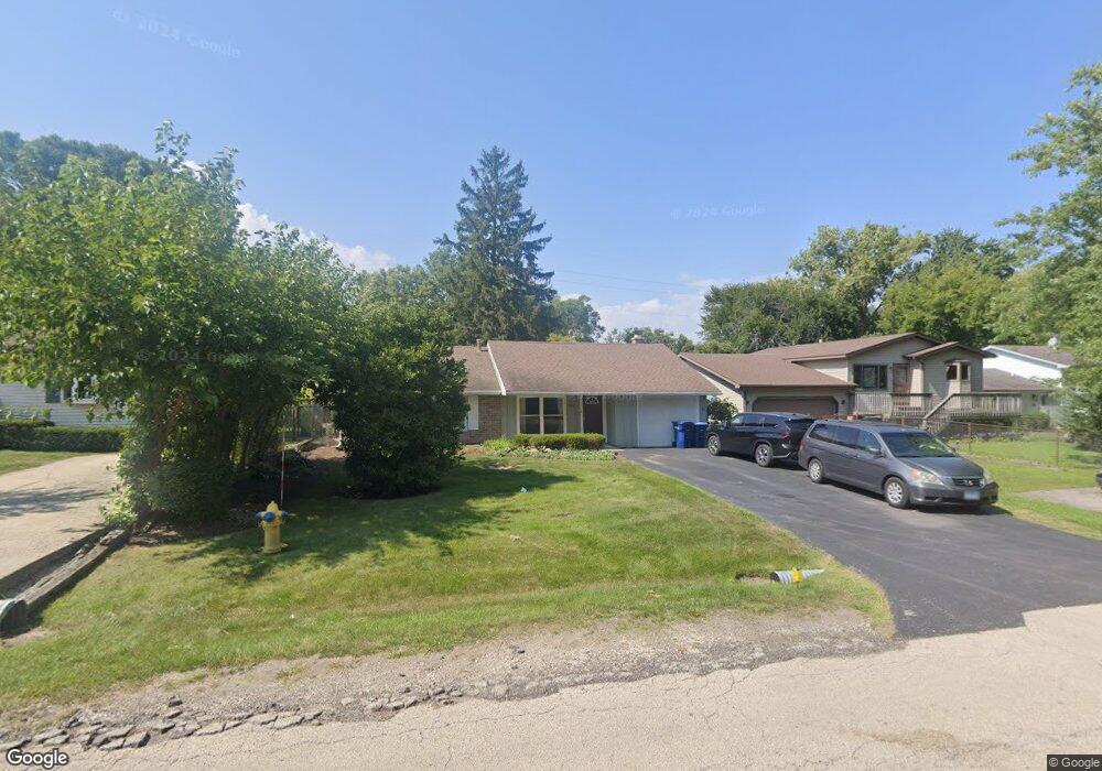
821 Jenkisson Ave Lake Bluff, IL 60044
Estimated Value: $345,000 - $401,387
3
Beds
2
Baths
1,080
Sq Ft
$351/Sq Ft
Est. Value
About This Home
This home is located at 821 Jenkisson Ave, Lake Bluff, IL 60044 and is currently estimated at $379,097, approximately $351 per square foot. 821 Jenkisson Ave is a home located in Lake County with nearby schools including Lake Bluff Elementary School, Lake Bluff Middle School, and Lake Forest High School.
Ownership History
Date
Name
Owned For
Owner Type
Purchase Details
Closed on
Mar 22, 2017
Sold by
Popp Michael and Rogers Donald F
Bought by
Tjarksen Properties Llc
Current Estimated Value
Purchase Details
Closed on
Feb 2, 2007
Sold by
Popp Laurie A and Nault Mary Ann
Bought by
Popp Michael
Purchase Details
Closed on
Jan 31, 2000
Sold by
French Jeffery S and French Marcia M
Bought by
Rogers Donald F and Rogers Carrie M
Home Financials for this Owner
Home Financials are based on the most recent Mortgage that was taken out on this home.
Original Mortgage
$212,000
Interest Rate
8%
Create a Home Valuation Report for This Property
The Home Valuation Report is an in-depth analysis detailing your home's value as well as a comparison with similar homes in the area
Home Values in the Area
Average Home Value in this Area
Purchase History
| Date | Buyer | Sale Price | Title Company |
|---|---|---|---|
| Tjarksen Properties Llc | $218,000 | Chicago Title | |
| Popp Michael | -- | First American Title Ins Co | |
| Rogers Donald F | $145,000 | -- |
Source: Public Records
Mortgage History
| Date | Status | Borrower | Loan Amount |
|---|---|---|---|
| Previous Owner | Rogers Donald F | $212,000 |
Source: Public Records
Tax History
| Year | Tax Paid | Tax Assessment Tax Assessment Total Assessment is a certain percentage of the fair market value that is determined by local assessors to be the total taxable value of land and additions on the property. | Land | Improvement |
|---|---|---|---|---|
| 2024 | $6,475 | $99,501 | $24,611 | $74,890 |
| 2023 | $6,475 | $91,723 | $22,687 | $69,036 |
| 2022 | $5,301 | $77,023 | $19,051 | $57,972 |
| 2021 | $5,193 | $76,359 | $18,887 | $57,472 |
| 2020 | $5,088 | $76,781 | $18,991 | $57,790 |
| 2019 | $4,909 | $75,371 | $18,642 | $56,729 |
| 2018 | $4,123 | $64,717 | $20,422 | $44,295 |
| 2017 | $4,090 | $63,636 | $20,081 | $43,555 |
| 2016 | $3,947 | $60,571 | $19,114 | $41,457 |
| 2015 | $3,906 | $57,035 | $17,998 | $39,037 |
| 2014 | $4,583 | $67,303 | $24,238 | $43,065 |
| 2012 | $4,278 | $67,887 | $24,448 | $43,439 |
Source: Public Records
Map
Nearby Homes
- 1004 Jenkisson Ave
- 907 W North Ave
- 717 Burris Ave
- 1107 Quassey Ave
- 905 Rockland Rd
- 2020 Knollwood Rd
- 11 Shagbark Rd
- 29644 N Birch Ave
- 511 Rockland Rd
- 110 Lauralton St Unit 34EEAS
- 12900 W Heiden Cir Unit 4204
- 1200 Regency Ln
- 301 Belle Foret Dr
- 13296 W Heiden Cir Unit 54
- 13000 W Heiden Cir Unit 3105
- 1061 Green Bay Rd
- 13200 W Heiden Cir Unit 2411
- 307 Forest View Dr
- 440 W Sheridan Place
- 510 Sunset Terrace
- 12746 Jenkisson Ave
- 819 Jenkisson Ave
- 12734 Jenkisson Ave
- 823 Jenkisson Ave
- 12758 Jenkisson Ave
- 12766 Jenkisson Ave
- 12722 Jenkisson Ave
- 820 Jenkisson Ave
- 12710 Jenkisson Ave
- 815 Jenkisson Ave
- 12698 Jenkisson Ave
- 215 Waukegan Rd
- 215 N Waukegan Rd Unit 2-N
- 215 N Waukegan Rd Unit 2-S
- 215 N Waukegan Rd Unit 1-N
- 215 N Waukegan Rd
- 215 Waukegan Rd Unit 1-N
- 29045 N Waukegan Rd
- 822 Smith Ave
- 29037 N Waukegan Rd
Your Personal Tour Guide
Ask me questions while you tour the home.