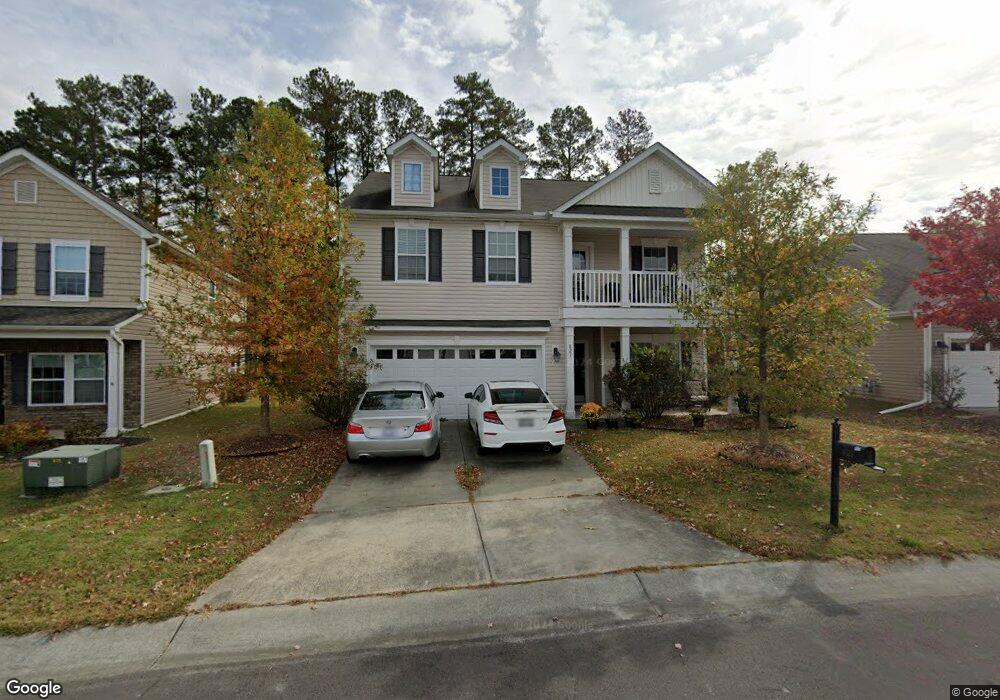
821 Poplar St Durham, NC 27703
Eastern Durham NeighborhoodEstimated Value: $482,000 - $505,000
5
Beds
3
Baths
2,677
Sq Ft
$185/Sq Ft
Est. Value
About This Home
This home is located at 821 Poplar St, Durham, NC 27703 and is currently estimated at $496,038, approximately $185 per square foot. 821 Poplar St is a home located in Durham County with nearby schools including Spring Valley Elementary School, John W Neal Middle School, and Southern School of Energy & Sustainability.
Ownership History
Date
Name
Owned For
Owner Type
Purchase Details
Closed on
Dec 27, 2013
Sold by
The Ryland Group Inc
Bought by
Campbell Roger R and Hylton Campbell Juliet
Current Estimated Value
Home Financials for this Owner
Home Financials are based on the most recent Mortgage that was taken out on this home.
Original Mortgage
$203,628
Outstanding Balance
$153,669
Interest Rate
4.38%
Mortgage Type
New Conventional
Estimated Equity
$342,369
Purchase Details
Closed on
Jun 26, 2013
Sold by
Gk Brightwood Lllp
Bought by
The Ryland Group Inc
Create a Home Valuation Report for This Property
The Home Valuation Report is an in-depth analysis detailing your home's value as well as a comparison with similar homes in the area
Home Values in the Area
Average Home Value in this Area
Purchase History
| Date | Buyer | Sale Price | Title Company |
|---|---|---|---|
| Campbell Roger R | $255,000 | None Available | |
| The Ryland Group Inc | $53,000 | None Available |
Source: Public Records
Mortgage History
| Date | Status | Borrower | Loan Amount |
|---|---|---|---|
| Open | Campbell Roger R | $203,628 |
Source: Public Records
Tax History
| Year | Tax Paid | Tax Assessment Tax Assessment Total Assessment is a certain percentage of the fair market value that is determined by local assessors to be the total taxable value of land and additions on the property. | Land | Improvement |
|---|---|---|---|---|
| 2025 | $5,238 | $528,352 | $107,625 | $420,727 |
| 2024 | $4,237 | $303,730 | $55,125 | $248,605 |
| 2023 | $3,979 | $303,730 | $55,125 | $248,605 |
| 2022 | $3,887 | $303,730 | $55,125 | $248,605 |
| 2021 | $3,869 | $303,730 | $55,125 | $248,605 |
| 2020 | $3,778 | $303,730 | $55,125 | $248,605 |
| 2019 | $3,778 | $303,730 | $55,125 | $248,605 |
| 2018 | $3,467 | $255,548 | $49,000 | $206,548 |
| 2017 | $3,441 | $255,548 | $49,000 | $206,548 |
| 2016 | $3,325 | $255,548 | $49,000 | $206,548 |
| 2015 | $3,250 | $234,763 | $46,827 | $187,936 |
| 2014 | $2,730 | $197,176 | $46,827 | $150,349 |
Source: Public Records
Map
Nearby Homes
- 108 Putters Ct
- 2208 Gilman St
- 807 Outlaw Ave
- 1114 Blackthorn Ln
- 807 Outlaw Ave Unit 19
- 428 Holly Blossom Dr
- 13 Blackthorn Ln
- 17 Plumleaf Ln
- The Poplar Plan at Sherron Road Townes
- 528 Plumleaf Ln
- 621 Wellwater Ave
- 1200 Constellation Cir
- 1128 Constellation Cir
- 1126 Constellation Cir
- 1124 Constellation Cir
- 3338 Prospect Pkwy
- 517 Keith St
- 1108 Constellation Cir
- 1114 Constellation Cir
- 1112 Constellation Cir
Your Personal Tour Guide
Ask me questions while you tour the home.