

822 W Bennett St Bridgeport, OH 43912
Estimated payment $31/month
Highlights
- Traditional Architecture
- Wood Siding
- No Heating
- No HOA
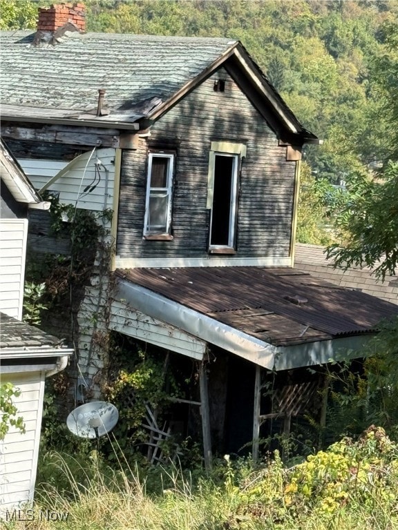
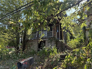
About This Home
This 2-bedroom, 1-bath home offers an investment opportunity for those looking for a redevelopment project. "The property cannot be safely entered, and the home’s condition is uncertain due to restricted access." It is being sold "as-is and sight unseen", and the condition of the interior, structure, and all systems is unknown. Potential buyers may visit the property with their agent but DO NOT ATTEMPT TO ENTER THE HOME.
Listing Agent
Real of Ohio Brokerage Email: debhomeseller@gmail.com, 740-632-7580 License #2020005667 Listed on: 11/15/2025
Co-Listing Agent
Real of Ohio Brokerage Email: debhomeseller@gmail.com, 740-632-7580 License #2018005608
Home Details
Home Type
- Single Family
Year Built
- Built in 1900
Parking
- Alley Access
Home Design
- Traditional Architecture
- Asphalt Roof
- Wood Siding
Bedrooms and Bathrooms
- 2 Bedrooms
- 1 Full Bathroom
Utilities
- No Cooling
- No Heating
Additional Features
- 2-Story Property
- 2,500 Sq Ft Lot
- Unfinished Basement
Community Details
- No Home Owners Association
- Hamlet/Kirkwood Subdivision
Listing and Financial Details
- Assessor Parcel Number 22-00340-000
Map
Home Values in the Area
Average Home Value in this Area
Tax History
| Year | Tax Paid | Tax Assessment Tax Assessment Total Assessment is a certain percentage of the fair market value that is determined by local assessors to be the total taxable value of land and additions on the property. | Land | Improvement |
|---|---|---|---|---|
| 2024 | $713 | $10,830 | $1,330 | $9,500 |
| 2023 | $1,238 | $12,110 | $1,340 | $10,770 |
| 2022 | $1,241 | $12,110 | $1,337 | $10,773 |
| 2021 | $1,561 | $12,110 | $1,337 | $10,773 |
| 2020 | $1,201 | $10,090 | $1,110 | $8,980 |
| 2019 | $627 | $10,090 | $1,110 | $8,980 |
| 2018 | $895 | $10,090 | $1,110 | $8,980 |
| 2017 | $326 | $6,770 | $740 | $6,030 |
| 2016 | $769 | $6,770 | $740 | $6,030 |
| 2015 | $495 | $6,770 | $740 | $6,030 |
| 2014 | $1,144 | $7,780 | $680 | $7,100 |
| 2013 | $519 | $7,780 | $680 | $7,100 |
Property History
| Date | Event | Price | List to Sale | Price per Sq Ft |
|---|---|---|---|---|
| 11/15/2025 11/15/25 | For Sale | $5,000 | -- | -- |
Purchase History
| Date | Type | Sale Price | Title Company |
|---|---|---|---|
| Sheriffs Deed | $18,200 | None Listed On Document | |
| Interfamily Deed Transfer | -- | Attorney | |
| Deed | $4,000 | -- | |
| Deed | -- | -- | |
| Deed | -- | -- | |
| Deed | -- | -- |
Source: MLS Now
MLS Number: 5172309
APN: 22-00340-000
Disclaimer: Certain information contained herein is derived from information provided by parties other than Homes.com. All information provided is deemed reliable, but is not guaranteed to be accurate and should be independently verified.
![]() IDX information is provided exclusively for personal, non-commercial use, and may not be used for any purpose other than to identify prospective properties consumers may be interested in purchasing. Information is deemed reliable but not guaranteed.
IDX information is provided exclusively for personal, non-commercial use, and may not be used for any purpose other than to identify prospective properties consumers may be interested in purchasing. Information is deemed reliable but not guaranteed.
- 629 1/2 Howard St
- 1049 Buckeye St
- 1123 Minellen Dr
- 866 Main St
- 67478 Kirkwood Heights Rd
- 308 Whitely St
- 6 Locust Ave
- 67531 Kirkwood Heights Rd
- 4 Walnut Ave
- 902 National Rd
- 67620 Kirkwood Heights Rd
- 244 Lombardy Heights
- 67730 Kirkwood Heights Rd
- 56624 Boyd Ave
- 56316 National Rd
- 149 Virginia St
- 0 Ohio 7
- 219 S York St
- 19 S Broadway St
- 50 Kentucky St
- 221 Howard St Unit 1
- 96 Maryland St Unit 96 Maryland
- 50 Kentucky St
- 118 3rd St Unit 118
- 8 5th St
- 1143 Main St
- 810 Main St
- 808 Main St
- 806 Main St
- 1025 Market St
- 2232 Eoff St
- 18 Mayo St
- 1411 McColloch St Unit 2B
- 108 S 4th St Unit 3
- 4000 Eoff St
- 700 Northwood Ct Unit 202
- 596 National Rd
- 250 Chapel Rd
- 250 Chapel Rd
- 410 N 7th St
