
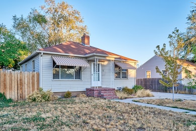
828 N 600 W Provo, UT 84604
Rivergrove NeighborhoodEstimated payment $2,282/month
Highlights
- Rambler Architecture
- No HOA
- Central Heating
- Wood Flooring
- Evaporated cooling system
- 5-minute walk to Provo City Park
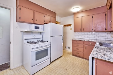
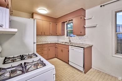
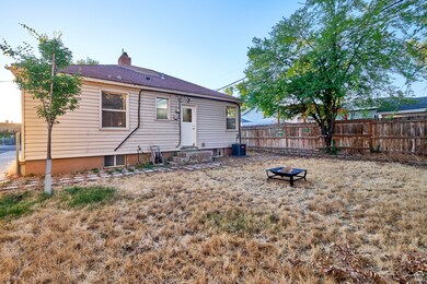
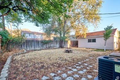
About This Home
Fantastic investment opportunity? A non-conforming duplex priced competitively (contact for details). This property features two separate units, each offering two spacious bedrooms and one full bathroom, making it an excellent choice for generating steady rental income. Perfect for investors or those looking to live in one unit while renting the other to offset mortgage costs, this duplex thrives in Provo's robust rental market, fueled by demand from students and young professionals near BYU and UVU. Its prime location places it minutes from Provo Canyon's scenic trails and the Provo River Parkway, ideal for outdoor enthusiasts, as well as downtown Provo's vibrant shops, restaurants, and attractions like the Covey Center for the Arts and the Provo City Center Temple. With easy access to I-15 for quick commutes to Salt Lake City and proximity to Utah Lake for recreation, this property appeals to a wide range of tenants. Move-in ready with classic charm and room for value-adding updates, this duplex is a rare opportunity. Schedule a showing today to explore its income potential! All information is deemed reliable but not guaranteed; buyer to verify all details.

Home Details
Home Type
- Single Family
Est. Annual Taxes
- $2,138
Year Built
- Built in 1952
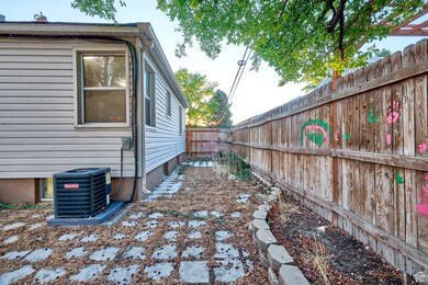
Lot Details
- 4,792 Sq Ft Lot
- Property is Fully Fenced
Parking
- 1 Car Garage
Home Design
- Rambler Architecture
- Asphalt
Interior Spaces
- 1,500 Sq Ft Home
- 2-Story Property
- Exterior Basement Entry
Flooring
- Wood
- Carpet
Bedrooms and Bathrooms
- 4 Bedrooms | 2 Main Level Bedrooms
- 2 Full Bathrooms
Laundry
- Dryer
- Washer
Schools
- Edgemont Elementary School
- Centennial Middle School
- Provo High School
Utilities
- Evaporated cooling system
- Central Heating
- Natural Gas Connected
Community Details
- No Home Owners Association
Listing and Financial Details
- Assessor Parcel Number 21-005-0036
Map
Home Values in the Area
Average Home Value in this Area
Tax History
| Year | Tax Paid | Tax Assessment Tax Assessment Total Assessment is a certain percentage of the fair market value that is determined by local assessors to be the total taxable value of land and additions on the property. | Land | Improvement |
|---|---|---|---|---|
| 2025 | $2,138 | $236,445 | $181,500 | $248,400 |
| 2024 | $2,138 | $210,485 | $0 | $0 |
| 2023 | $2,126 | $206,305 | $0 | $0 |
| 2022 | $2,101 | $205,535 | $0 | $0 |
| 2021 | $1,523 | $259,900 | $108,400 | $151,500 |
| 2020 | $1,476 | $236,200 | $98,500 | $137,700 |
| 2019 | $1,345 | $223,800 | $86,100 | $137,700 |
| 2018 | $1,202 | $202,800 | $83,100 | $119,700 |
| 2017 | $1,074 | $99,550 | $0 | $0 |
| 2016 | $991 | $85,635 | $0 | $0 |
| 2015 | $885 | $77,330 | $0 | $0 |
| 2014 | $881 | $80,190 | $0 | $0 |
Property History
| Date | Event | Price | List to Sale | Price per Sq Ft |
|---|---|---|---|---|
| 11/09/2025 11/09/25 | Pending | -- | -- | -- |
| 11/05/2025 11/05/25 | Price Changed | $400,000 | -3.6% | $267 / Sq Ft |
| 10/29/2025 10/29/25 | Price Changed | $415,000 | -2.4% | $277 / Sq Ft |
| 09/25/2025 09/25/25 | For Sale | $425,000 | -- | $283 / Sq Ft |
Purchase History
| Date | Type | Sale Price | Title Company |
|---|---|---|---|
| Deed | -- | -- | |
| Warranty Deed | -- | None Available | |
| Warranty Deed | -- | None Available | |
| Warranty Deed | -- | Horizon Title | |
| Warranty Deed | -- | Horizon Title | |
| Warranty Deed | -- | -- |
Mortgage History
| Date | Status | Loan Amount | Loan Type |
|---|---|---|---|
| Open | $222,934 | No Value Available | |
| Closed | -- | No Value Available | |
| Previous Owner | $121,829 | No Value Available |
Source: UtahRealEstate.com
MLS Number: 2113717
APN: 21-005-0036
Disclaimer: Certain information contained herein is derived from information provided by parties other than Homes.com. All information provided is deemed reliable, but is not guaranteed to be accurate and should be independently verified.
![]() IDX information is provided exclusively for consumers’ personal, non-commercial use, that it may not be used for any purpose other than to identify prospective properties consumers may be interested in purchasing, and that the data is deemed reliable but is not guaranteed accurate by the MLS. Licensor is only providing the MLS Content and not other sources of data provided in the Product.
IDX information is provided exclusively for consumers’ personal, non-commercial use, that it may not be used for any purpose other than to identify prospective properties consumers may be interested in purchasing, and that the data is deemed reliable but is not guaranteed accurate by the MLS. Licensor is only providing the MLS Content and not other sources of data provided in the Product.
Based on information from the Wasatch Front Regional Multiple Listing Service, Inc.. All data, including all measurements and calculations of area, is obtained from various sources and has not been, and will not be, verified by broker or the MLS. All information should be independently reviewed and verified for accuracy. Properties may or may not be listed by the office/agent presenting the information.