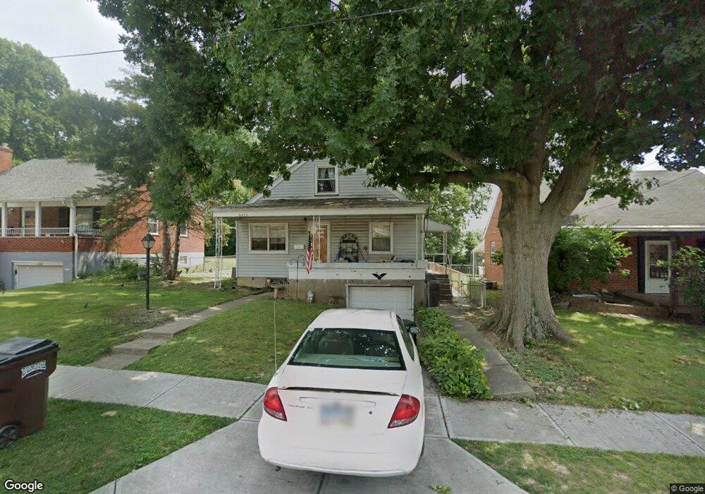
8282 Lyness Dr Cincinnati, OH 45239
Estimated Value: $164,000 - $179,000
3
Beds
1
Bath
1,199
Sq Ft
$143/Sq Ft
Est. Value
About This Home
This home is located at 8282 Lyness Dr, Cincinnati, OH 45239 and is currently estimated at $171,901, approximately $143 per square foot. 8282 Lyness Dr is a home located in Hamilton County with nearby schools including White Oak Middle School, Colerain High School, and Cincinnati Achievement Academy.
Ownership History
Date
Name
Owned For
Owner Type
Purchase Details
Closed on
Jun 22, 1994
Sold by
Gray Carlos and Dickman Julianna Marie
Bought by
Riggs John Lee
Current Estimated Value
Home Financials for this Owner
Home Financials are based on the most recent Mortgage that was taken out on this home.
Original Mortgage
$62,600
Interest Rate
8.78%
Create a Home Valuation Report for This Property
The Home Valuation Report is an in-depth analysis detailing your home's value as well as a comparison with similar homes in the area
Home Values in the Area
Average Home Value in this Area
Purchase History
| Date | Buyer | Sale Price | Title Company |
|---|---|---|---|
| Riggs John Lee | -- | -- |
Source: Public Records
Mortgage History
| Date | Status | Borrower | Loan Amount |
|---|---|---|---|
| Closed | Riggs John Lee | $62,600 |
Source: Public Records
Tax History
| Year | Tax Paid | Tax Assessment Tax Assessment Total Assessment is a certain percentage of the fair market value that is determined by local assessors to be the total taxable value of land and additions on the property. | Land | Improvement |
|---|---|---|---|---|
| 2025 | $2,271 | $38,826 | $7,483 | $31,343 |
| 2023 | $2,113 | $38,826 | $7,483 | $31,343 |
| 2022 | $1,594 | $23,780 | $5,856 | $17,924 |
| 2021 | $1,580 | $23,780 | $5,856 | $17,924 |
| 2020 | $1,596 | $23,780 | $5,856 | $17,924 |
| 2019 | $1,450 | $20,153 | $4,963 | $15,190 |
| 2018 | $1,304 | $20,153 | $4,963 | $15,190 |
| 2017 | $1,236 | $20,153 | $4,963 | $15,190 |
| 2016 | $1,340 | $21,602 | $6,811 | $14,791 |
| 2015 | $1,353 | $21,602 | $6,811 | $14,791 |
| 2014 | $1,355 | $21,602 | $6,811 | $14,791 |
| 2013 | $1,405 | $23,479 | $7,403 | $16,076 |
Source: Public Records
Map
Nearby Homes
- 8278 Lyness Dr
- 2750 W Galbraith Rd
- 2807 W Galbraith Rd
- 2701 Hennge Dr
- 2736 Barthas Place
- 2655 Barthas Place
- 8228 Haskell Dr
- 8265 Haskell Dr
- 2680 Royal Glen Dr
- 8545 Noelle Dr
- 2564 Altura Dr
- 3069 Sovereign Dr
- 2335 Bluelark Dr
- 8241 Georgianna Dr
- 8628 Paisley Dr
- 3269 Warfield Ave
- 8526 Neptune Dr
- 3194 Harry Lee Ln
- 7560 Pippin Rd
- 2836 Banning Rd
- 8288 Lyness Dr
- 8298 Lyness Dr
- 8274 Lyness Dr
- 8289 Royal Heights Dr
- 8271 Royal Heights Dr
- 8306 Lyness Dr
- 8263 Royal Heights Dr
- 8299 Royal Heights Dr
- 8281 Lyness Dr
- 8270 Lyness Dr
- 8289 Lyness Dr
- 8277 Lyness Dr
- 8253 Royal Heights Dr
- 8307 Royal Heights Dr
- 8299 Lyness Dr
- 8316 Lyness Dr
- 8271 Lyness Dr
- 8307 Lyness Dr
- 8317 Royal Heights Dr
- 8324 Lyness Dr
Your Personal Tour Guide
Ask me questions while you tour the home.