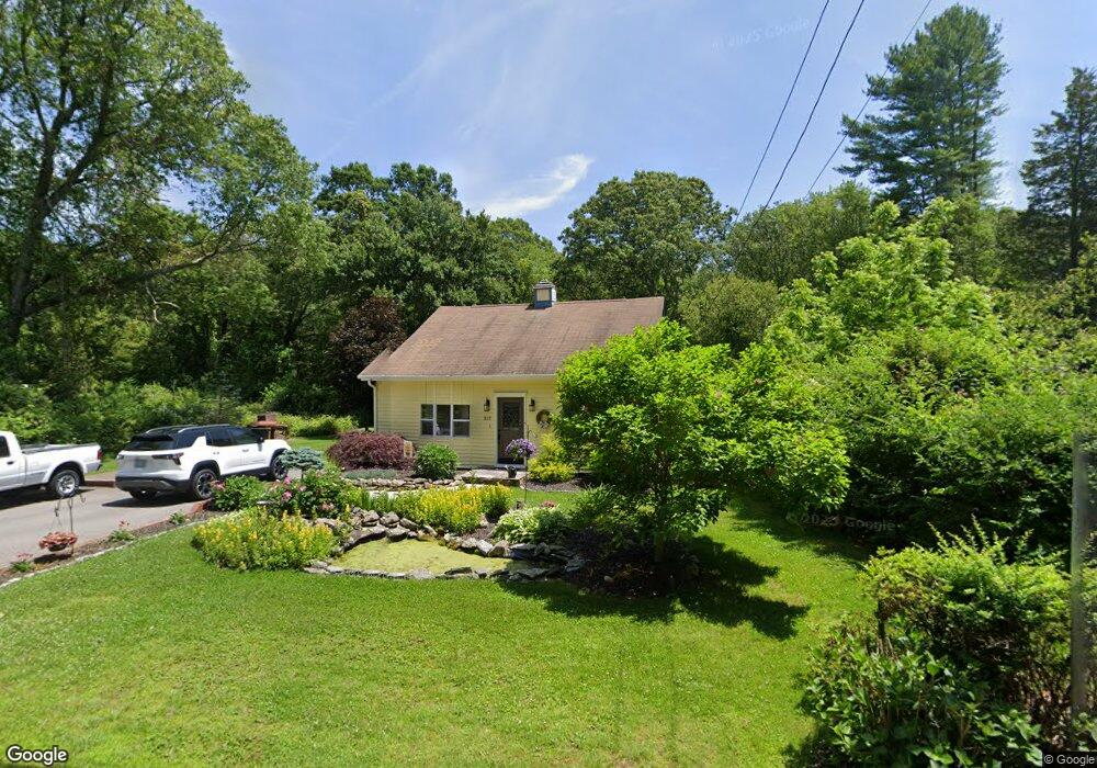
829 Broad Rock Rd Wakefield, RI 02879
Estimated Value: $322,000 - $441,000
2
Beds
1
Bath
972
Sq Ft
$409/Sq Ft
Est. Value
About This Home
This home is located at 829 Broad Rock Rd, Wakefield, RI 02879 and is currently estimated at $397,131, approximately $408 per square foot. 829 Broad Rock Rd is a home located in Washington County with nearby schools including South Kingstown High School, Monsignor Matthew Clarke Catholic Regional School, and South Shore School.
Ownership History
Date
Name
Owned For
Owner Type
Purchase Details
Closed on
Oct 5, 2012
Sold by
Bouchard Arthur E and Bouchard Mary A
Bought by
Bouchard Arthur E and Bouchard Mary A
Current Estimated Value
Home Financials for this Owner
Home Financials are based on the most recent Mortgage that was taken out on this home.
Original Mortgage
$73,514
Outstanding Balance
$50,903
Interest Rate
3.66%
Estimated Equity
$346,228
Purchase Details
Closed on
Dec 16, 2011
Sold by
Bouchard Arthur E and Bouchard Mary Ann
Bought by
Bourchard Arthur E and Bouchard Maryann
Purchase Details
Closed on
Aug 18, 2010
Sold by
Branch Banking & T Co
Bought by
Department Of Housing & Urban Dev
Purchase Details
Closed on
Aug 8, 2006
Sold by
Sisson Millard and Sisson Susan
Bought by
Kilgore Steven and Gough Kristine
Create a Home Valuation Report for This Property
The Home Valuation Report is an in-depth analysis detailing your home's value as well as a comparison with similar homes in the area
Home Values in the Area
Average Home Value in this Area
Purchase History
| Date | Buyer | Sale Price | Title Company |
|---|---|---|---|
| Bouchard Arthur E | -- | -- | |
| Bourchard Arthur E | -- | -- | |
| Bourchard Arthur E | $85,000 | -- | |
| Department Of Housing & Urban Dev | $338,500 | -- | |
| Kilgore Steven | $260,000 | -- |
Source: Public Records
Mortgage History
| Date | Status | Borrower | Loan Amount |
|---|---|---|---|
| Open | Kilgore Steven | $73,514 | |
| Closed | Kilgore Steven | $73,514 | |
| Previous Owner | Kilgore Steven | $308,560 |
Source: Public Records
Tax History
| Year | Tax Paid | Tax Assessment Tax Assessment Total Assessment is a certain percentage of the fair market value that is determined by local assessors to be the total taxable value of land and additions on the property. | Land | Improvement |
|---|---|---|---|---|
| 2025 | $2,931 | $327,800 | $160,200 | $167,600 |
| 2024 | $2,860 | $258,800 | $123,400 | $135,400 |
| 2023 | $2,860 | $258,800 | $123,400 | $135,400 |
| 2022 | $2,834 | $258,800 | $123,400 | $135,400 |
| 2021 | $2,943 | $203,700 | $101,600 | $102,100 |
| 2020 | $2,943 | $203,700 | $101,600 | $102,100 |
| 2019 | $2,943 | $203,700 | $101,600 | $102,100 |
| 2018 | $2,863 | $182,600 | $98,200 | $84,400 |
| 2017 | $2,796 | $182,600 | $98,200 | $84,400 |
| 2016 | $2,755 | $182,600 | $98,200 | $84,400 |
| 2015 | $2,738 | $176,400 | $92,400 | $84,000 |
| 2014 | $2,731 | $176,400 | $92,400 | $84,000 |
Source: Public Records
Map
Nearby Homes
- 261 Saugatucket Rd
- 0 Indian Trail Trail S Unit 1389828
- 95 S Woods Dr
- 0 Indian Run Trail Unit 1403300
- 15 Jessica Ln
- 57 Rocky Brook Way
- 301 Church St Unit 103
- 9 Edwards Ave
- 48 Stone Bridge Dr
- 131 Columbia St
- 143 Summit Ave
- 5 Wayland Trail
- 37 Columbia St
- 20 Cleveland St
- 45 Cherry Ln Unit C
- 416 Bridgetown Rd
- 39 Hazard Ave
- 40 Northup St
- 106 S Bay Dr
- 260 Sweet Allen Farm Rd Unit 3
- 806 Broad Rock Rd
- 451 Broad Rock Rd
- 80 Broad Rock Rd
- 815 Broad Rock Rd
- 843 Broad Rock Rd
- 0 Woodmist Cir Unit 1048689
- 0 Woodmist Cir Unit 1037201
- 824 Broad Rock Rd
- 853 Broad Rock Rd
- 15 Woodmist Cir
- 863 Broad Rock Rd
- 791 Broad Rock Rd
- 30 Woodmist Cir
- 871 Broad Rock Rd
- 804 Broad Rock Rd
- 781 Broad Rock Rd
- 786 Broad Rock Rd
- 889 Broad Rock Rd
- 35 Woodmist Cir
- 882 Broad Rock Rd
Your Personal Tour Guide
Ask me questions while you tour the home.