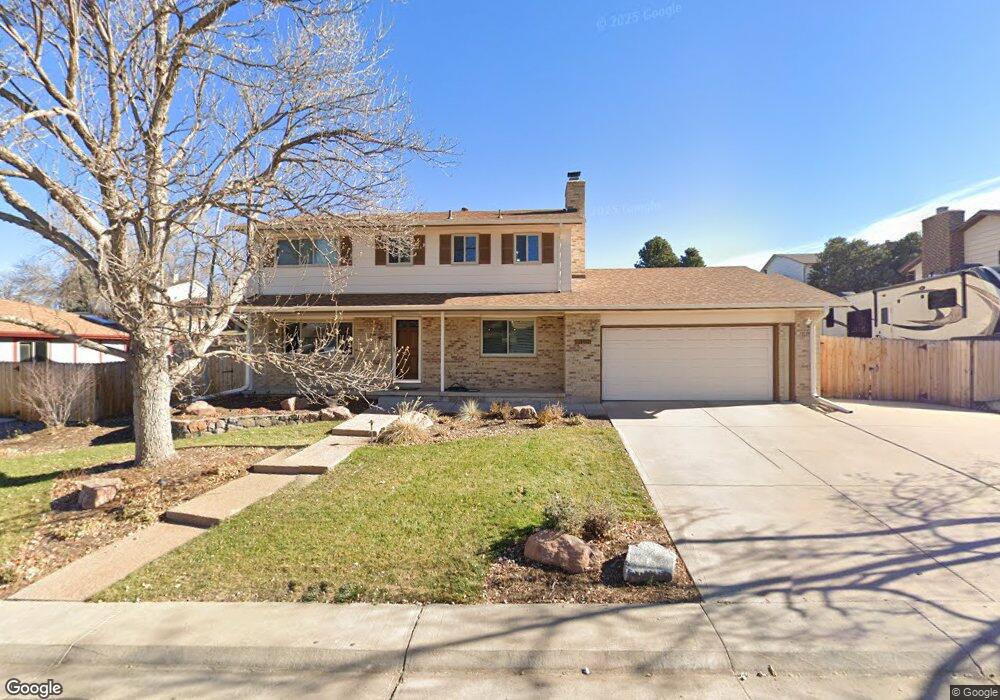
829 Mercury Cir Lone Tree, CO 80124
Estimated Value: $557,428 - $579,000
4
Beds
3
Baths
1,984
Sq Ft
$286/Sq Ft
Est. Value
About This Home
This home is located at 829 Mercury Cir, Lone Tree, CO 80124 and is currently estimated at $568,214, approximately $286 per square foot. 829 Mercury Cir is a home located in Douglas County with nearby schools including Acres Green Elementary School, Cresthill Middle School, and Highlands Ranch High School.
Ownership History
Date
Name
Owned For
Owner Type
Purchase Details
Closed on
Jun 16, 1998
Sold by
Davis Gary E and Davis Jo Nancy
Bought by
Ruby John M and Ruby Amy H
Current Estimated Value
Home Financials for this Owner
Home Financials are based on the most recent Mortgage that was taken out on this home.
Original Mortgage
$152,100
Outstanding Balance
$28,293
Interest Rate
7.21%
Estimated Equity
$539,921
Purchase Details
Closed on
Jun 26, 1985
Sold by
Gill Richard Co
Bought by
Davis Gary E and Davis Nancy Jo
Purchase Details
Closed on
Oct 17, 1979
Sold by
Unavailable
Bought by
Unavailable
Create a Home Valuation Report for This Property
The Home Valuation Report is an in-depth analysis detailing your home's value as well as a comparison with similar homes in the area
Home Values in the Area
Average Home Value in this Area
Purchase History
| Date | Buyer | Sale Price | Title Company |
|---|---|---|---|
| Ruby John M | $169,000 | -- | |
| Davis Gary E | $80,000 | -- | |
| Unavailable | $72,700 | -- |
Source: Public Records
Mortgage History
| Date | Status | Borrower | Loan Amount |
|---|---|---|---|
| Open | Ruby John M | $152,100 |
Source: Public Records
Tax History
| Year | Tax Paid | Tax Assessment Tax Assessment Total Assessment is a certain percentage of the fair market value that is determined by local assessors to be the total taxable value of land and additions on the property. | Land | Improvement |
|---|---|---|---|---|
| 2025 | $2,760 | $36,190 | $6,980 | $29,210 |
| 2024 | $2,760 | $40,460 | $8,120 | $32,340 |
| 2023 | $3,409 | $40,460 | $8,120 | $32,340 |
| 2022 | $2,580 | $28,970 | $6,890 | $22,080 |
| 2021 | $2,683 | $28,970 | $6,890 | $22,080 |
| 2020 | $2,563 | $28,350 | $6,520 | $21,830 |
| 2019 | $2,571 | $28,350 | $6,520 | $21,830 |
| 2018 | $2,055 | $24,270 | $5,670 | $18,600 |
| 2017 | $2,089 | $24,270 | $5,670 | $18,600 |
| 2016 | $1,874 | $21,330 | $4,080 | $17,250 |
| 2015 | $1,917 | $21,330 | $4,080 | $17,250 |
| 2014 | $1,726 | $17,990 | $3,980 | $14,010 |
Source: Public Records
Map
Nearby Homes
- 789 Mercury Cir
- 13226 Canopus Dr
- 8852 Chestnut Hill Ln
- 6945 Mountain Brush Cir
- 7057 Chestnut Hill St
- 6823 Edgewood Place
- 9314 Wiltshire Dr
- 7191 Palisade Dr
- 8159 Lodgepole Trail
- 9466 Wiltshire Dr
- 8214 Lodgepole Trail
- 6483 Laguna Cir
- 9390 Yale Ln
- 9320 Miles Dr
- 7459 La Quinta Place
- 6494 Silver Mesa Dr Unit A
- 9395 Princeton Cir
- 9631 Kemper Dr
- 9366 Cornell Cir
- 8558 Gold Peak Ln Unit B
- 835 Mercury Cir
- 827 Mercury Cir
- 13143 Hadar Dr
- 13153 Hadar Dr
- 13133 Hadar Dr
- 839 Mercury Cir
- 13163 Hadar Dr
- 956 Hamal Dr
- 830 Mercury Cir
- 828 Mercury Cir
- 832 Mercury Cir
- 936 Hamal Dr
- 845 Mercury Cir
- 826 Mercury Cir
- 897 Hamal Dr
- 13173 Hadar Dr
- 13154 Hadar Dr
- 926 Hamal Dr
- 13144 Hadar Dr
- 844 Mercury Cir
Your Personal Tour Guide
Ask me questions while you tour the home.