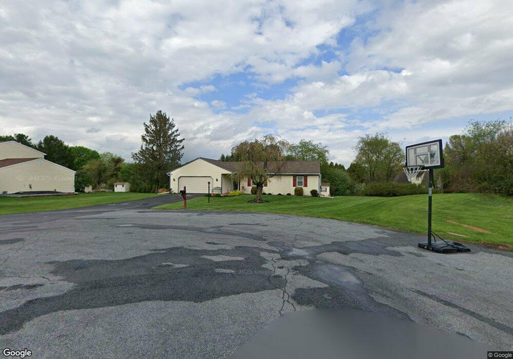
83 Anthony Ln Honey Brook, PA 19344
Estimated Value: $391,000 - $466,000
3
Beds
2
Baths
1,588
Sq Ft
$265/Sq Ft
Est. Value
About This Home
This home is located at 83 Anthony Ln, Honey Brook, PA 19344 and is currently estimated at $420,995, approximately $265 per square foot. 83 Anthony Ln is a home located in Chester County with nearby schools including Honey Brook Elementary Center, Twin Valley Middle School, and Twin Valley High School.
Ownership History
Date
Name
Owned For
Owner Type
Purchase Details
Closed on
Sep 2, 2005
Sold by
Downingtown National Bank
Bought by
Peters Ted E and Peters Judith A
Current Estimated Value
Purchase Details
Closed on
Feb 25, 1997
Sold by
Pnc Bank National Assn
Bought by
Downingtown National Bank
Purchase Details
Closed on
Jul 18, 1996
Sold by
Wescott Joseph and Wescott Lorraine
Bought by
Pnc Bank National Assn
Create a Home Valuation Report for This Property
The Home Valuation Report is an in-depth analysis detailing your home's value as well as a comparison with similar homes in the area
Home Values in the Area
Average Home Value in this Area
Purchase History
| Date | Buyer | Sale Price | Title Company |
|---|---|---|---|
| Peters Ted E | $220,000 | Clt | |
| Downingtown National Bank | -- | -- | |
| Pnc Bank National Assn | $139,000 | -- |
Source: Public Records
Tax History Compared to Growth
Tax History
| Year | Tax Paid | Tax Assessment Tax Assessment Total Assessment is a certain percentage of the fair market value that is determined by local assessors to be the total taxable value of land and additions on the property. | Land | Improvement |
|---|---|---|---|---|
| 2025 | $5,297 | $137,970 | $24,940 | $113,030 |
| 2024 | $5,297 | $137,970 | $24,940 | $113,030 |
| 2023 | $5,176 | $137,970 | $24,940 | $113,030 |
| 2022 | $5,120 | $137,970 | $24,940 | $113,030 |
| 2021 | $4,970 | $137,970 | $24,940 | $113,030 |
| 2020 | $4,945 | $137,970 | $24,940 | $113,030 |
| 2019 | $4,798 | $137,970 | $24,940 | $113,030 |
| 2018 | $4,798 | $137,970 | $24,940 | $113,030 |
| 2017 | $4,685 | $137,970 | $24,940 | $113,030 |
| 2016 | $3,713 | $137,970 | $24,940 | $113,030 |
| 2015 | $3,713 | $137,970 | $24,940 | $113,030 |
| 2014 | $3,713 | $137,970 | $24,940 | $113,030 |
Source: Public Records
Map
Nearby Homes
- 35 Wagon Way
- 407 Cahill Cir Unit 4
- 12 Vintage Ln
- 159 Augusta Dr
- 70 Waynebrook Dr
- 50 Nevin Dr
- 0 Westbrook Dr
- 0 Westbrook Dr
- 0 Westbrook Dr
- 0 Westbrook Dr
- 650 Dampman Rd
- 230 Rock Rd
- 110 Hillbrook Dr
- 2200 Beaver Dam Rd
- 1 Tulip Dr
- 14 Blue Spruce Dr
- 109 Brylin Dr
- 607 Buchland Rd
- 113 Keystone Ct
- 1022 Elwood St
- 95 Anthony Ln
- 79 Anthony Ln
- 133 Roberts Ln
- 105 Anthony Ln
- 80 Anthony Ln
- 90 Anthony Ln
- 40 Scarlett Oaks Cir
- 423 Park Rd
- 30 Scarlett Oaks Cir
- 123 Anthony Ln
- 100 Anthony Ln
- 143 Roberts Ln
- 20 Scarlett Oaks Cir
- 121 Roberts Ln
- 50 Scarlett Oaks Cir
- 120 Anthony Ln
- 115 Roberts Ln
- 10 Scarlett Oaks Cir
- 133 Anthony Ln
- 47 Wagon Way