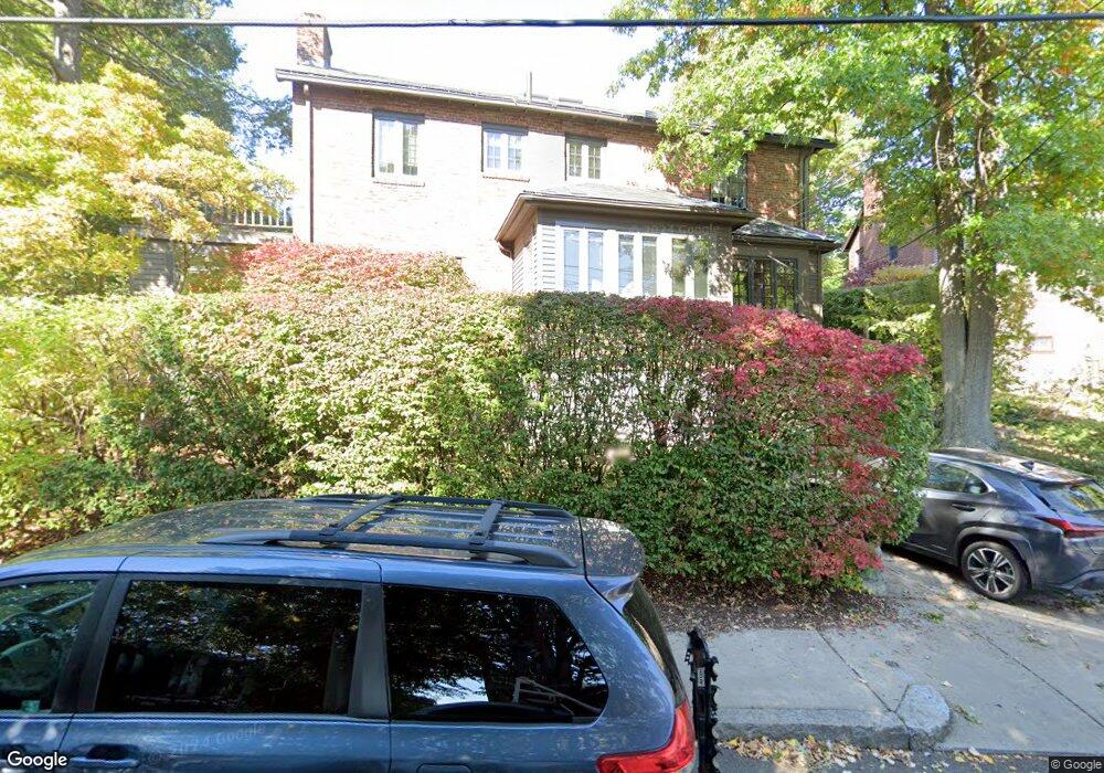
83 Blake Rd Brookline, MA 02445
Washington Square NeighborhoodEstimated Value: $2,694,000 - $3,095,000
3
Beds
4
Baths
2,608
Sq Ft
$1,095/Sq Ft
Est. Value
About This Home
This home is located at 83 Blake Rd, Brookline, MA 02445 and is currently estimated at $2,856,981, approximately $1,095 per square foot. 83 Blake Rd is a home located in Norfolk County with nearby schools including Pierce School, Brookline High School, and Maimonides School.
Ownership History
Date
Name
Owned For
Owner Type
Purchase Details
Closed on
Oct 2, 2024
Sold by
Seely Ellen W
Bought by
Ellen Seely Ret and Seely
Current Estimated Value
Purchase Details
Closed on
May 28, 2009
Sold by
Seely Ellen W and Strongin Jonathan D
Bought by
Seely Ellen W
Purchase Details
Closed on
Oct 13, 1988
Sold by
Doris Rt
Bought by
Seely Ellen W
Create a Home Valuation Report for This Property
The Home Valuation Report is an in-depth analysis detailing your home's value as well as a comparison with similar homes in the area
Home Values in the Area
Average Home Value in this Area
Purchase History
| Date | Buyer | Sale Price | Title Company |
|---|---|---|---|
| Ellen Seely Ret | -- | None Available | |
| Ellen Seely Ret | -- | None Available | |
| Seely Ellen W | -- | -- | |
| Seely Ellen W | -- | -- | |
| Seely Ellen W | $430,000 | -- |
Source: Public Records
Mortgage History
| Date | Status | Borrower | Loan Amount |
|---|---|---|---|
| Previous Owner | Seely Ellen W | $120,000 | |
| Previous Owner | Seely Ellen W | $60,000 | |
| Previous Owner | Seely Ellen W | $32,000 |
Source: Public Records
Tax History
| Year | Tax Paid | Tax Assessment Tax Assessment Total Assessment is a certain percentage of the fair market value that is determined by local assessors to be the total taxable value of land and additions on the property. | Land | Improvement |
|---|---|---|---|---|
| 2025 | $27,089 | $2,744,600 | $1,507,200 | $1,237,400 |
| 2024 | $25,836 | $2,644,400 | $1,449,100 | $1,195,300 |
| 2023 | $24,049 | $2,412,100 | $1,159,000 | $1,253,100 |
| 2022 | $23,408 | $2,297,200 | $1,103,800 | $1,193,400 |
| 2021 | $21,646 | $2,208,800 | $1,061,300 | $1,147,500 |
| 2020 | $19,829 | $2,098,300 | $964,800 | $1,133,500 |
| 2019 | $18,725 | $1,998,400 | $918,900 | $1,079,500 |
| 2018 | $16,276 | $1,720,500 | $765,800 | $954,700 |
| 2017 | $16,036 | $1,623,100 | $722,400 | $900,700 |
| 2016 | $15,806 | $1,516,900 | $675,200 | $841,700 |
| 2015 | $15,141 | $1,417,700 | $631,000 | $786,700 |
| 2014 | $14,641 | $1,285,400 | $525,800 | $759,600 |
Source: Public Records
Map
Nearby Homes
- 71 Greenough St Unit 71-1
- 15 Colbourne Crescent Unit 2
- 140 Sumner Rd Unit 1
- 84 Winthrop Rd Unit 1
- 84 Winthrop Rd
- 24 Blake Rd
- 101 Winthrop Rd Unit 1
- 90 Addington Rd Unit 1
- 90 Addington Rd Unit 2
- 89 University Rd
- 115 Clark Rd
- 4 Fairbanks St Unit 2
- 57 University Rd Unit 3
- 1517 Beacon St Unit 4
- 1495 Beacon St Unit G
- 401 Washington St Unit 6
- 20 Claflin Rd Unit A
- 11 Goodwin Place Unit 1
- 11 Goodwin Place Unit 11-1
- 11 Goodwin Place Unit 11-2
Your Personal Tour Guide
Ask me questions while you tour the home.