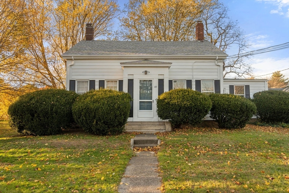
83 Fairhaven Rd Mattapoisett, MA 02739
Estimated payment $3,213/month
Highlights
- Marina
- Golf Course Community
- Medical Services
- Old Hammondtown Elementary Rated A-
- Community Stables
- Wood Flooring
About This Home
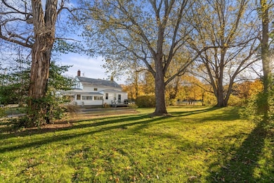
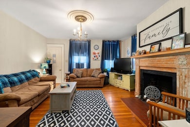
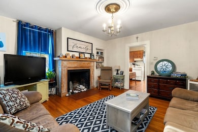
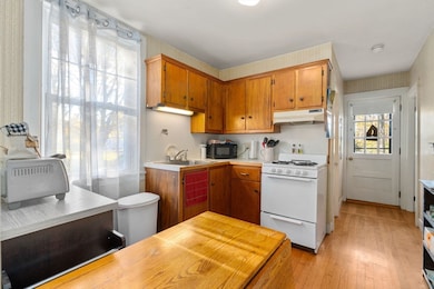
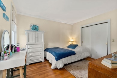
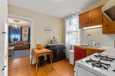
Located in the heart of Mattapoisett, one of the South Coast’s most cherished seaside towns, this inviting two-family home blends timeless charm with modern opportunity. Built in 1920, the 1,792 sq ft residence offers two warm and welcoming units, each with hardwood floors, gas heat, and full kitchens and baths. Set on a generous 0.76-acre lot, the property features a garage, enclosed porch, and a beautiful back yard space - perfect for morning coffee, summer gatherings, or relaxing in the ocean breeze. With 3 bedrooms and 2 baths across 7 rooms, it’s ideal for first-time home buyers seeking income potential, multi-generational living, or a smart investment. From here, stroll or bike to Mattapoisett Village, local beaches, and the scenic bike path or walking trails. Just minutes from the harbor and local shops, this home captures the essence of coastal living - where community, comfort, and seaside beauty come together.
Property Details
Home Type
- Multi-Family
Est. Annual Taxes
- $3,374
Year Built
- Built in 1920
Lot Details
- 0.76 Acre Lot
- Level Lot
Parking
- 4 Car Parking Spaces
Home Design
- Duplex
- Stone Foundation
- Frame Construction
- Shingle Roof
Interior Spaces
- 1,792 Sq Ft Home
- Property has 2 Levels
- 1 Fireplace
- Living Room
- Basement Fills Entire Space Under The House
Kitchen
- Country Kitchen
- Range
Flooring
- Wood
- Carpet
- Laminate
- Vinyl
Bedrooms and Bathrooms
- 3 Bedrooms
- 2 Full Bathrooms
Utilities
- Sewer Inspection Required for Sale
- Internet Available
Additional Features
- Enclosed Patio or Porch
- Property is near schools
Listing and Financial Details
- Rent includes unit 2(none)
- Assessor Parcel Number M:21.0 L:46.0,1088428
Community Details
Overview
- 2 Units
- Near Conservation Area
Amenities
- Medical Services
- Shops
- Coin Laundry
Recreation
- Marina
- Golf Course Community
- Tennis Courts
- Community Pool
- Community Stables
- Jogging Path
- Bike Trail
Building Details
- Net Operating Income $13,500
Map
Home Values in the Area
Average Home Value in this Area
Tax History
| Year | Tax Paid | Tax Assessment Tax Assessment Total Assessment is a certain percentage of the fair market value that is determined by local assessors to be the total taxable value of land and additions on the property. | Land | Improvement |
|---|---|---|---|---|
| 2025 | $3,374 | $313,600 | $164,600 | $149,000 |
| 2024 | $3,296 | $313,600 | $164,600 | $149,000 |
| 2023 | $3,311 | $294,300 | $146,900 | $147,400 |
| 2022 | $3,089 | $249,100 | $122,500 | $126,600 |
| 2021 | $2,911 | $224,600 | $98,000 | $126,600 |
| 2020 | $3,161 | $234,300 | $93,300 | $141,000 |
| 2019 | $2,889 | $218,700 | $77,700 | $141,000 |
| 2018 | $2,420 | $185,900 | $90,200 | $95,700 |
| 2017 | $2,610 | $199,700 | $104,000 | $95,700 |
| 2016 | $2,944 | $223,000 | $117,900 | $105,100 |
| 2015 | $2,809 | $216,100 | $111,000 | $105,100 |
| 2014 | $2,806 | $220,600 | $111,000 | $109,600 |
Property History
| Date | Event | Price | List to Sale | Price per Sq Ft |
|---|---|---|---|---|
| 12/06/2025 12/06/25 | Pending | -- | -- | -- |
| 11/06/2025 11/06/25 | For Sale | $559,000 | -- | $312 / Sq Ft |
Purchase History
| Date | Type | Sale Price | Title Company |
|---|---|---|---|
| Quit Claim Deed | -- | -- | |
| Quit Claim Deed | -- | -- | |
| Deed | -- | -- | |
| Deed | -- | -- |
Mortgage History
| Date | Status | Loan Amount | Loan Type |
|---|---|---|---|
| Previous Owner | $165,000 | No Value Available | |
| Previous Owner | $80,000 | No Value Available | |
| Previous Owner | $45,100 | No Value Available |
Source: MLS Property Information Network (MLS PIN)
MLS Number: 73452073
APN: MATT-000210-000000-000460
Disclaimer: Certain information contained herein is derived from information provided by parties other than Homes.com. All information provided is deemed reliable, but is not guaranteed to be accurate and should be independently verified.
![]() The property listing data and information, or the Images, set forth herein were provided to MLS Property Information Network, Inc. from third party sources, including sellers, lessors and public records, and were compiled by MLS Property Information Network, Inc. The property listing data and information, and the Images, are for the personal, non-commercial use of consumers having a good faith interest in purchasing or leasing listed properties of the type displayed to them and may not be used for any purpose other than to identify prospective properties which such consumers may have a good faith interest in purchasing or leasing. MLS Property Information Network, Inc. and its subscribers disclaim any and all representations and warranties as to the accuracy of the property listing data and information, or as to the accuracy of any of the Images, set forth herein.
The property listing data and information, or the Images, set forth herein were provided to MLS Property Information Network, Inc. from third party sources, including sellers, lessors and public records, and were compiled by MLS Property Information Network, Inc. The property listing data and information, and the Images, are for the personal, non-commercial use of consumers having a good faith interest in purchasing or leasing listed properties of the type displayed to them and may not be used for any purpose other than to identify prospective properties which such consumers may have a good faith interest in purchasing or leasing. MLS Property Information Network, Inc. and its subscribers disclaim any and all representations and warranties as to the accuracy of the property listing data and information, or as to the accuracy of any of the Images, set forth herein.
- 3 Brandt Island Rd
- 47 Fairhaven Rd
- 421 Huttleston Ave
- 20 Forestview Dr
- 0 Whalers Way
- 7 Pearl St
- 9 Hitching Post Rd
- 41 Starboard Way
- 1 Starboard Way
- 13 Park Place
- 35 North St
- 8 Captains Ln
- 11 Captains Ln
- 6 Meadowbrook Ln
- 0 Harbor Acres Ln - Lot B
- 0 Marina Dr Unit 72497908
- 0 Marina Dr Unit 72497877
- 312 New Boston Rd
- 15 Ned's Point Rd
- 28 Brandt Beach Ave
