Estimated Value: $806,492 - $946,000
3
Beds
2
Baths
1,570
Sq Ft
$549/Sq Ft
Est. Value
About This Home
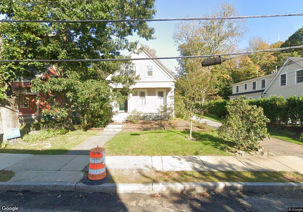
This home is located at 83 High St, Newton Upper Falls, MA 02464 and is currently estimated at $861,623, approximately $548 per square foot. 83 High St is a home located in Middlesex County with nearby schools including Angier Elementary School, Zervas Elementary School, and Charles E Brown Middle School.
Ownership History
Date
Name
Owned For
Owner Type
Purchase Details
Closed on
Aug 13, 2009
Sold by
Mcbailey Barbara Mc
Bought by
Barbara Bailey Ret and Bailey Barbara
Current Estimated Value
Purchase Details
Closed on
Dec 14, 1992
Sold by
Kilburn Donald C and Leroy Lisa J
Bought by
Mcbailey Barbara
Purchase Details
Closed on
Sep 22, 1988
Sold by
Krellenstein Marc
Bought by
Kilburn Donald C
Create a Home Valuation Report for This Property
The Home Valuation Report is an in-depth analysis detailing your home's value as well as a comparison with similar homes in the area
Home Values in the Area
Average Home Value in this Area
Purchase History
| Date | Buyer | Sale Price | Title Company |
|---|---|---|---|
| Barbara Bailey Ret | -- | -- | |
| Mcbailey Barbara | $200,000 | -- | |
| Kilburn Donald C | $190,840 | -- |
Source: Public Records
Mortgage History
| Date | Status | Borrower | Loan Amount |
|---|---|---|---|
| Previous Owner | Kilburn Donald C | $333,100 | |
| Previous Owner | Kilburn Donald C | $276,800 | |
| Previous Owner | Kilburn Donald C | $262,500 |
Source: Public Records
Tax History
| Year | Tax Paid | Tax Assessment Tax Assessment Total Assessment is a certain percentage of the fair market value that is determined by local assessors to be the total taxable value of land and additions on the property. | Land | Improvement |
|---|---|---|---|---|
| 2025 | $6,859 | $699,900 | $0 | $699,900 |
| 2024 | $6,632 | $679,500 | $0 | $679,500 |
| 2023 | $6,922 | $634,700 | $0 | $634,700 |
| 2022 | $6,813 | $604,500 | $0 | $604,500 |
| 2021 | $6,136 | $570,300 | $0 | $570,300 |
| 2020 | $5,954 | $570,300 | $0 | $570,300 |
| 2019 | $5,786 | $553,700 | $0 | $553,700 |
| 2018 | $5,796 | $535,700 | $0 | $535,700 |
| 2017 | $5,620 | $505,400 | $0 | $505,400 |
| 2016 | $5,375 | $472,300 | $0 | $472,300 |
| 2015 | $5,222 | $449,800 | $0 | $449,800 |
Source: Public Records
Map
Nearby Homes
- 1003 Chestnut St
- 300 Elliot St Unit 2
- 27 Hamilton Place
- 14 Pennsylvania Ave Unit 14
- 20 Pennsylvania Ave
- 20 Pennsylvania Ave Unit 20
- 12 Pennsylvania Ave Unit 14
- 59 Roundwood Rd
- 200 Elliot St Unit 1
- 873 Chestnut St
- 66 Linden St
- 1077 Boylston St Unit 1
- 18 Josselyn Place Unit 18
- 16-18 Josselyn Place Unit 16
- 187 Saint Mary St
- 181 Saint Mary St
- 18 Evergreen Rd
- 27 High St Unit 27
- 25 High St Unit 25
- 25 High St
- 83 High St Unit 83A
- 85 High St
- 75 High St Unit 2
- 75 High St Unit 1
- 75 High St Unit 1R
- 75 High St
- 71 High St
- 84 Rockland Place
- 91 High St
- 65 High St
- 65 High St Unit 65-2
- 65 High St Unit 65-1
- 65 High St Unit 2
- 65 High St Unit 1
- 65 High St Unit A
- 65 High St Unit B
- 80 High St Unit 82
- 80 High St Unit 80
- 80 High St Unit 1
- 80 High St Unit 2
Your Personal Tour Guide
Ask me questions while you tour the home.