
Seller's Agent in 2025
Amanda Thaw
The Riverside Realty Group
(917) 270-0344
2 in this area
36 Total Sales
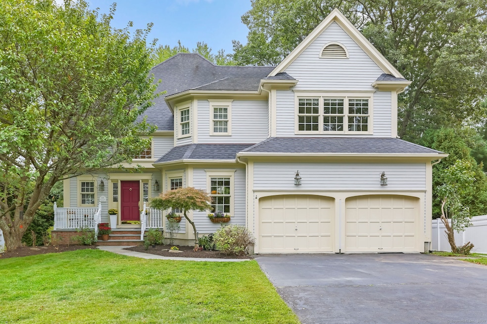
Welcome to 83 Mailands Road ~ Tucked away on one of the most desirable cul-de-sacs in Fairfield's sought-after University area, this sunny and beautiful 4-bedroom Colonial offers classic charm combined with modern convenience. The home features a double-height great room with fireplace, flooding the space with natural light and creating an inviting atmosphere for entertaining and everyday living. A formal dining room provides the perfect setting for special occasions, while the eat-in kitchen with island and granite counters offers a warm space for casual meals. Both the kitchen and great room open to a spacious deck, seamlessly blending indoor and outdoor living ideal for entertaining or relaxing in the private backyard. The first-floor office adds versatility for remote work or study. Upstairs, the second level boasts four generously sized bedrooms, including a spacious primary suite. Set on a .28-acre lot, this home features a lovely landscaped yard easily accessed from the deck or the extra-large, walk out lower level just waiting to be finished. Conveniently located near top-rated schools, shopping, dining, train stations, and Fairfield's scenic beaches, this home offers the best of suburban living. Don't miss this rare opportunity to own in one of Fairfield's most desirable neighborhoods!
Last Agent to Sell the Property
The Riverside Realty Group Brokerage Phone: (917) 270-0344 License #RES.0797749 Listed on: 09/24/2025
| Date | Type | Sale Price | Title Company |
|---|---|---|---|
| Executors Deed | $1,500,000 | -- | |
| Warranty Deed | $550,400 | -- | |
| Warranty Deed | $550,400 | -- |
| Date | Status | Loan Amount | Loan Type |
|---|---|---|---|
| Open | $1,200,000 | Purchase Money Mortgage | |
| Previous Owner | $67,000 | No Value Available | |
| Previous Owner | $75,000 | Purchase Money Mortgage |
| Date | Event | Price | List to Sale | Price per Sq Ft |
|---|---|---|---|---|
| 10/29/2025 10/29/25 | Sold | $1,500,000 | +11.2% | $470 / Sq Ft |
| 10/05/2025 10/05/25 | Pending | -- | -- | -- |
| 09/25/2025 09/25/25 | For Sale | $1,349,000 | -- | $422 / Sq Ft |
| Year | Tax Paid | Tax Assessment Tax Assessment Total Assessment is a certain percentage of the fair market value that is determined by local assessors to be the total taxable value of land and additions on the property. | Land | Improvement |
|---|---|---|---|---|
| 2025 | $16,970 | $597,730 | $280,560 | $317,170 |
| 2024 | $16,677 | $597,730 | $280,560 | $317,170 |
| 2023 | $16,444 | $597,730 | $280,560 | $317,170 |
| 2022 | $16,282 | $597,730 | $280,560 | $317,170 |
| 2021 | $16,127 | $597,730 | $280,560 | $317,170 |
| 2020 | $18,117 | $676,270 | $277,620 | $398,650 |
| 2019 | $18,117 | $676,270 | $277,620 | $398,650 |
| 2018 | $17,826 | $676,270 | $277,620 | $398,650 |
| 2017 | $17,461 | $676,270 | $277,620 | $398,650 |
| 2016 | $17,211 | $676,270 | $277,620 | $398,650 |
| 2015 | $15,283 | $616,490 | $292,250 | $324,240 |
| 2014 | $15,042 | $616,490 | $292,250 | $324,240 |
Seller's Agent in 2025
Amanda Thaw
The Riverside Realty Group
(917) 270-0344
2 in this area
36 Total Sales
Buyer's Agent in 2025
Cindy Raney
Coldwell Banker Realty
(203) 625-1820
12 in this area
144 Total Sales
Source: SmartMLS
MLS Number: 24077374
APN: FAIR-000145-000000-000072-J000000
Disclaimer: Certain information contained herein is derived from information provided by parties other than Homes.com. All information provided is deemed reliable, but is not guaranteed to be accurate and should be independently verified.
![]() IDX information is provided exclusively for personal, non-commercial use, and may not be used for any purpose other than to identify prospective properties consumers may be interested in purchasing. Information is deemed reliable but not guaranteed.
IDX information is provided exclusively for personal, non-commercial use, and may not be used for any purpose other than to identify prospective properties consumers may be interested in purchasing. Information is deemed reliable but not guaranteed.
Ask me questions while you tour the home.