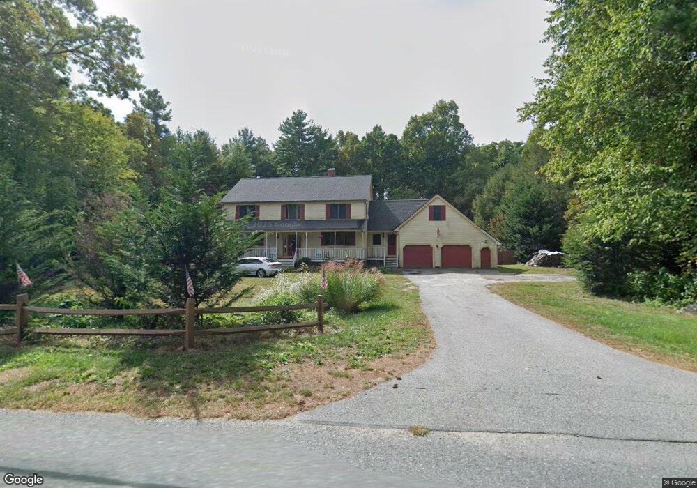
83 Martin St Rehoboth, MA 02769
Estimated Value: $764,211 - $957,000
4
Beds
3
Baths
2,783
Sq Ft
$306/Sq Ft
Est. Value
About This Home
This home is located at 83 Martin St, Rehoboth, MA 02769 and is currently estimated at $852,553, approximately $306 per square foot. 83 Martin St is a home located in Bristol County with nearby schools including Dighton-Rehoboth Regional High School.
Ownership History
Date
Name
Owned For
Owner Type
Purchase Details
Closed on
Sep 17, 2020
Sold by
Francis Stephanie M
Bought by
Francis William T
Current Estimated Value
Purchase Details
Closed on
Aug 27, 2003
Sold by
Martin Regina C
Bought by
Francis William T and Francis Stephanie M
Purchase Details
Closed on
Jul 21, 2003
Sold by
Martin Craig J and Martin Regina C
Bought by
Martin Regina C
Purchase Details
Closed on
Feb 19, 1999
Sold by
Lambert Daniel and Lambert Linda M
Bought by
Martin Craig J and Martin Regina C
Purchase Details
Closed on
Oct 31, 1997
Sold by
Hathaway Roger F and Hathaway Margaret J
Bought by
John Claire Rt
Purchase Details
Closed on
May 13, 1993
Sold by
Galen Corp
Bought by
Lambert Daniel and Lambert Linda M
Create a Home Valuation Report for This Property
The Home Valuation Report is an in-depth analysis detailing your home's value as well as a comparison with similar homes in the area
Home Values in the Area
Average Home Value in this Area
Purchase History
| Date | Buyer | Sale Price | Title Company |
|---|---|---|---|
| Francis William T | -- | None Available | |
| Francis William T | $391,500 | -- | |
| Martin Regina C | -- | -- | |
| Martin Craig J | $275,000 | -- | |
| John Claire Rt | $60,000 | -- | |
| Lambert Daniel | $72,500 | -- |
Source: Public Records
Mortgage History
| Date | Status | Borrower | Loan Amount |
|---|---|---|---|
| Previous Owner | Lambert Daniel | $327,000 | |
| Previous Owner | Lambert Daniel | $359,000 |
Source: Public Records
Tax History Compared to Growth
Tax History
| Year | Tax Paid | Tax Assessment Tax Assessment Total Assessment is a certain percentage of the fair market value that is determined by local assessors to be the total taxable value of land and additions on the property. | Land | Improvement |
|---|---|---|---|---|
| 2025 | $68 | $608,800 | $174,600 | $434,200 |
| 2024 | $6,530 | $574,800 | $174,600 | $400,200 |
| 2023 | $6,047 | $522,000 | $171,000 | $351,000 |
| 2022 | $6,047 | $477,300 | $171,000 | $306,300 |
| 2021 | $5,879 | $444,000 | $163,200 | $280,800 |
| 2020 | $5,825 | $444,000 | $163,200 | $280,800 |
| 2018 | $4,987 | $416,600 | $155,400 | $261,200 |
| 2017 | $4,822 | $383,900 | $155,400 | $228,500 |
| 2016 | $4,664 | $383,900 | $155,400 | $228,500 |
| 2015 | $4,590 | $372,900 | $148,200 | $224,700 |
| 2014 | $4,549 | $365,700 | $141,000 | $224,700 |
Source: Public Records
Map
Nearby Homes
- 79 Martin St
- 87 Martin St
- 78 Martin St
- 1 Tiger Lily Trail
- 22 Cameron Way
- 5 Tiger Lily Trail
- 26 Cameron Way
- 18 Cameron Way
- 71 Martin St
- 9 Tiger Lily Trail
- 72 Martin St
- 0 Cameron Way
- 95 Martin St
- 14 Cameron Way
- 6 Tiger Lily Trail
- 68 Martin St
- 10 Tiger Lily Trail
- 23 Cameron Way
- 19 Cameron Way
- 67 Martin St