


83 Massasoit Rd Worcester, MA 01604
Grafton Hill NeighborhoodEstimated payment $2,849/month
Highlights
- Colonial Architecture
- Wood Flooring
- 1 Car Attached Garage
- Deck
- No HOA
- Cedar Closet
About This Home
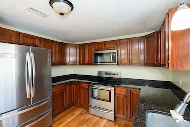
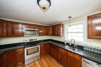
Discover an inviting home awaiting you at 83 Massasoit Rd, Worcester, MA. This single-family residence is ready to move in. Spacious home with large kitchen, featuring beautiful cabinetry, granite countertops and stainless appliances. The open floor plan of this home encourages a sense of togetherness and makes the space feel more expansive. Hardwood flooring on the first floor. 260 sqft in finished lower level, central air, one garage space and more. The property also features a nice deck, providing the perfect setting for outdoor relaxation. Built in 2010, this property blends modern construction with comfortable living. Excellent commuter location for UMASS Medical and all major routes. Minutes to Routes146, 90, 290, and 20. Embrace the opportunity to make this fabulous property your own!

Home Details
Home Type
- Single Family
Est. Annual Taxes
- $5,152
Year Built
- Built in 2010
Lot Details
- 4,182 Sq Ft Lot
- Property fronts a private road
- Zero Lot Line
- Property is zoned RL-7
Parking
- 1 Car Attached Garage
- Tuck Under Parking
- Garage Door Opener
- Driveway
- 3 Open Parking Spaces
- Off-Street Parking
Home Design
- Manufactured Home on a slab
- Colonial Architecture
- Split Level Home
- Frame Construction
- Shingle Roof
- Asphalt Roof
- Concrete Perimeter Foundation
Interior Spaces
- Insulated Windows
- Window Screens
- Insulated Doors
- Basement Fills Entire Space Under The House
Kitchen
- Range
- Microwave
- Dishwasher
Flooring
- Wood
- Laminate
Bedrooms and Bathrooms
- 3 Bedrooms
- Cedar Closet
- 2 Full Bathrooms
Laundry
- Dryer
- Washer
Outdoor Features
- Deck
- Exterior Lighting
Schools
- Rice Square Elementary School
- East Middle School
- North High School
Utilities
- Forced Air Heating and Cooling System
- 1 Cooling Zone
- 1 Heating Zone
- 100 Amp Service
- Gas Water Heater
Community Details
- No Home Owners Association
- Rice Square Subdivision
Listing and Financial Details
- Assessor Parcel Number M:34 B:003 L:022B,4824639
Map
Home Values in the Area
Average Home Value in this Area
Tax History
| Year | Tax Paid | Tax Assessment Tax Assessment Total Assessment is a certain percentage of the fair market value that is determined by local assessors to be the total taxable value of land and additions on the property. | Land | Improvement |
|---|---|---|---|---|
| 2025 | $5,152 | $390,600 | $86,400 | $304,200 |
| 2024 | $4,912 | $357,200 | $86,400 | $270,800 |
| 2023 | $4,712 | $328,600 | $75,100 | $253,500 |
| 2022 | $4,292 | $282,200 | $60,100 | $222,100 |
| 2021 | $4,194 | $257,600 | $48,100 | $209,500 |
| 2020 | $4,083 | $240,200 | $48,100 | $192,100 |
| 2019 | $3,931 | $218,400 | $43,300 | $175,100 |
| 2018 | $3,924 | $207,500 | $43,300 | $164,200 |
| 2017 | $3,706 | $192,800 | $43,300 | $149,500 |
| 2016 | $3,720 | $180,500 | $32,700 | $147,800 |
| 2015 | $3,623 | $180,500 | $32,700 | $147,800 |
| 2014 | $3,527 | $180,500 | $32,700 | $147,800 |
Property History
| Date | Event | Price | List to Sale | Price per Sq Ft |
|---|---|---|---|---|
| 01/11/2026 01/11/26 | Pending | -- | -- | -- |
| 01/10/2026 01/10/26 | Price Changed | $460,000 | -3.2% | $262 / Sq Ft |
| 01/04/2026 01/04/26 | Price Changed | $475,000 | -4.0% | $271 / Sq Ft |
| 12/17/2025 12/17/25 | For Sale | $495,000 | -- | $282 / Sq Ft |
Purchase History
| Date | Type | Sale Price | Title Company |
|---|---|---|---|
| Not Resolvable | $197,000 | -- |
Mortgage History
| Date | Status | Loan Amount | Loan Type |
|---|---|---|---|
| Open | $192,006 | FHA |
Source: MLS Property Information Network (MLS PIN)
MLS Number: 73462723
APN: WORC-000034-000003-000002-000002B
Disclaimer: Certain information contained herein is derived from information provided by parties other than Homes.com. All information provided is deemed reliable, but is not guaranteed to be accurate and should be independently verified.
![]() The property listing data and information, or the Images, set forth herein were provided to MLS Property Information Network, Inc. from third party sources, including sellers, lessors and public records, and were compiled by MLS Property Information Network, Inc. The property listing data and information, and the Images, are for the personal, non-commercial use of consumers having a good faith interest in purchasing or leasing listed properties of the type displayed to them and may not be used for any purpose other than to identify prospective properties which such consumers may have a good faith interest in purchasing or leasing. MLS Property Information Network, Inc. and its subscribers disclaim any and all representations and warranties as to the accuracy of the property listing data and information, or as to the accuracy of any of the Images, set forth herein.
The property listing data and information, or the Images, set forth herein were provided to MLS Property Information Network, Inc. from third party sources, including sellers, lessors and public records, and were compiled by MLS Property Information Network, Inc. The property listing data and information, and the Images, are for the personal, non-commercial use of consumers having a good faith interest in purchasing or leasing listed properties of the type displayed to them and may not be used for any purpose other than to identify prospective properties which such consumers may have a good faith interest in purchasing or leasing. MLS Property Information Network, Inc. and its subscribers disclaim any and all representations and warranties as to the accuracy of the property listing data and information, or as to the accuracy of any of the Images, set forth herein.
- 20 Brightwood Ave
- 62 Allston Ave
- 143 Dorcester
- 429 Grafton St Unit 2
- 53 Denver Terrace
- 80 Delmont Ave
- 56 Plantation St
- 155 Hamilton St Unit 4
- 35 Houghton St
- 81 Pilgrim Ave
- 41 Bridgeport St
- 57 Cutler St
- 32 Granite St
- 256 Massasoit Rd
- 25 Stoneham Rd
- 259 Massasoit Rd
- 12 Benham St
- 47 Barclay St
- 40 Aetna St
- 21 Bolton St
Ask me questions while you tour the home.