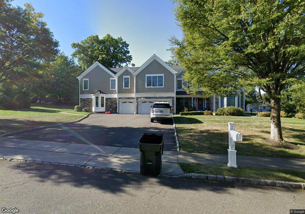
83 Poplar Dr Paramus, NJ 07652
Estimated Value: $1,987,000 - $2,349,000
Studio
--
Bath
5,410
Sq Ft
$407/Sq Ft
Est. Value
About This Home
This home is located at 83 Poplar Dr, Paramus, NJ 07652 and is currently estimated at $2,200,132, approximately $406 per square foot. 83 Poplar Dr is a home located in Bergen County with nearby schools including Paramus High School, Yeshivat Noam School, and Yavneh Academy.
Ownership History
Date
Name
Owned For
Owner Type
Purchase Details
Closed on
Dec 27, 2011
Sold by
Sperber David and Sperber Lisa
Bought by
Feorenzo Dawn
Current Estimated Value
Purchase Details
Closed on
Sep 16, 2002
Sold by
Pulte Home Corp Of The Delawar
Bought by
Ward Glenn and Ward Kathy E
Home Financials for this Owner
Home Financials are based on the most recent Mortgage that was taken out on this home.
Original Mortgage
$612,000
Interest Rate
6.27%
Mortgage Type
Purchase Money Mortgage
Create a Home Valuation Report for This Property
The Home Valuation Report is an in-depth analysis detailing your home's value as well as a comparison with similar homes in the area
Home Values in the Area
Average Home Value in this Area
Purchase History
| Date | Buyer | Sale Price | Title Company |
|---|---|---|---|
| Feorenzo Dawn | $918,000 | -- | |
| Ward Glenn | $770,000 | -- |
Source: Public Records
Mortgage History
| Date | Status | Borrower | Loan Amount |
|---|---|---|---|
| Previous Owner | Ward Glenn | $612,000 |
Source: Public Records
Tax History
| Year | Tax Paid | Tax Assessment Tax Assessment Total Assessment is a certain percentage of the fair market value that is determined by local assessors to be the total taxable value of land and additions on the property. | Land | Improvement |
|---|---|---|---|---|
| 2025 | $25,452 | $1,735,600 | $585,000 | $1,150,600 |
| 2024 | $24,475 | $1,681,100 | $585,000 | $1,096,100 |
| 2023 | $23,811 | $1,595,500 | $537,800 | $1,057,700 |
| 2022 | $23,811 | $1,534,200 | $537,800 | $996,400 |
| 2021 | $23,206 | $1,403,500 | $486,000 | $917,500 |
| 2020 | $22,194 | $1,391,500 | $486,000 | $905,500 |
| 2019 | $20,342 | $1,096,000 | $426,400 | $669,600 |
| 2018 | $20,090 | $1,096,000 | $426,400 | $669,600 |
| 2017 | $19,739 | $1,096,000 | $426,400 | $669,600 |
| 2016 | $19,202 | $1,096,000 | $426,400 | $669,600 |
| 2015 | $19,005 | $1,096,000 | $426,400 | $669,600 |
| 2014 | $18,840 | $953,200 | $426,400 | $526,800 |
Source: Public Records
Map
Nearby Homes
- 4-21 Saddle River Rd
- 39-16 Northern Dr
- 15 Wyckoff Terrace
- 39-01 Broadway Unit B
- 3901 Broadway Unit B
- 39-02 Taylor Rd
- 70 S Paramus Rd
- 37-27 Hale Place Unit 1X
- 0- 54 Yost Place
- 054 Yost Place
- 211 Denver Rd
- 1-37 34th St
- 298 Buttonwood Dr
- 32-06 Rosalie St
- 219 N Farview Ave
- 31-12 Rosalie St
- 30-06 Morlot Ave Unit 1X
- 16-30 Saddle River Rd
- 64 E Century Rd
- 28-07 Zachary Terrace Unit 1X
- 81 Poplar Dr
- 85 Poplar Dr
- 219 Alpine Dr
- 227 Alpine Dr
- 102 Scarlet Oak Ln
- 74 Mulberry Ct
- 104 Scarlet Oak Ln
- 72 Mulberry Ct
- 1 Scarlet Oak Ln
- 106 Scarlet Oak Ln
- 3 Scarlet Oak Ln
- 70 Mulberry Ct
- 108 Scarlet Oak Ln
- 51 Mulberry Ct
- 2 Thistle Dr
- 68 Mulberry Ct Unit C0068
- 5 Scarlet Oak Ln
- 49 Mulberry Ct
- 4 Thistle Dr
- 235 Alpine Dr
Your Personal Tour Guide
Ask me questions while you tour the home.