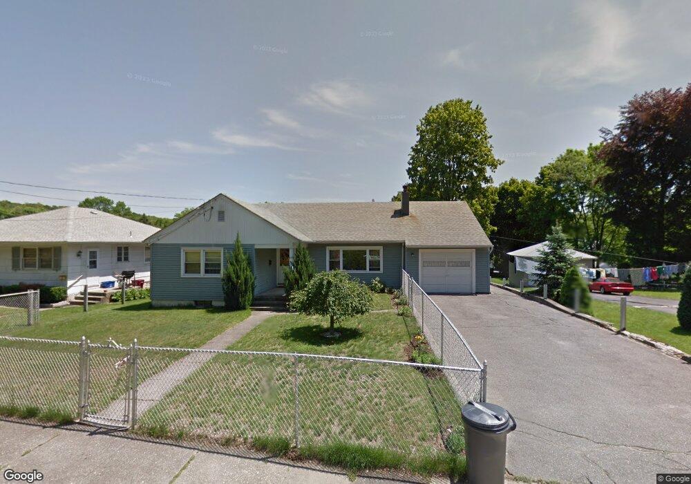
83 School St Naugatuck, CT 06770
Estimated Value: $222,000 - $357,000
3
Beds
1
Bath
1,312
Sq Ft
$235/Sq Ft
Est. Value
About This Home
This home is located at 83 School St, Naugatuck, CT 06770 and is currently estimated at $307,913, approximately $234 per square foot. 83 School St is a home located in New Haven County with nearby schools including City Hill Middle School and Naugatuck High School.
Ownership History
Date
Name
Owned For
Owner Type
Purchase Details
Closed on
Apr 26, 2012
Sold by
Rego Albino D and Rego Ilda F
Bought by
Rego Serafim and Rego Andre
Current Estimated Value
Purchase Details
Closed on
Jul 12, 1999
Sold by
Adamski Ed Est and Adamski
Bought by
Rego Albino and Rego Ilda
Home Financials for this Owner
Home Financials are based on the most recent Mortgage that was taken out on this home.
Original Mortgage
$43,000
Interest Rate
7.5%
Mortgage Type
Purchase Money Mortgage
Create a Home Valuation Report for This Property
The Home Valuation Report is an in-depth analysis detailing your home's value as well as a comparison with similar homes in the area
Home Values in the Area
Average Home Value in this Area
Purchase History
| Date | Buyer | Sale Price | Title Company |
|---|---|---|---|
| Rego Serafim | -- | -- | |
| Rego Albino | $102,500 | -- |
Source: Public Records
Mortgage History
| Date | Status | Borrower | Loan Amount |
|---|---|---|---|
| Previous Owner | Rego Albino | $43,000 |
Source: Public Records
Tax History
| Year | Tax Paid | Tax Assessment Tax Assessment Total Assessment is a certain percentage of the fair market value that is determined by local assessors to be the total taxable value of land and additions on the property. | Land | Improvement |
|---|---|---|---|---|
| 2025 | $6,047 | $151,970 | $19,880 | $132,090 |
| 2024 | $6,351 | $151,970 | $19,880 | $132,090 |
| 2023 | $6,801 | $151,970 | $19,880 | $132,090 |
| 2022 | $4,689 | $98,190 | $16,810 | $81,380 |
| 2021 | $4,689 | $98,190 | $16,810 | $81,380 |
| 2020 | $4,689 | $98,190 | $16,810 | $81,380 |
| 2019 | $4,639 | $98,190 | $16,810 | $81,380 |
| 2018 | $4,623 | $95,620 | $31,450 | $64,170 |
| 2017 | $4,642 | $95,620 | $31,450 | $64,170 |
| 2016 | $4,558 | $95,620 | $31,450 | $64,170 |
| 2015 | $4,357 | $95,620 | $31,450 | $64,170 |
| 2014 | $4,309 | $95,620 | $31,450 | $64,170 |
| 2012 | $4,958 | $147,790 | $45,950 | $101,840 |
Source: Public Records
Map
Nearby Homes
- 48 Anderson St
- 465 N Main St
- 18 Bridge St Unit 1O
- 55 Porter Ave Unit 6E
- 32 Stanley St
- 545 N Church St
- 22 Neagle St
- 119 Prospect St
- 231 N Main St
- 23 Salem St
- 0 Field St Unit 170385250
- 23 Thunderbird Dr
- 69 Nancy Ln
- 66 Nancy Ln
- 163 City Hill St
- 92A Thunderbird Dr
- 125 Thunderbird Dr
- 210 Johnson St
- 461 Spring St Unit 3
- 41 Millville Ave Unit 201
Your Personal Tour Guide
Ask me questions while you tour the home.