Estimated Value: $722,000 - $848,000
4
Beds
3
Baths
1,638
Sq Ft
$474/Sq Ft
Est. Value
About This Home
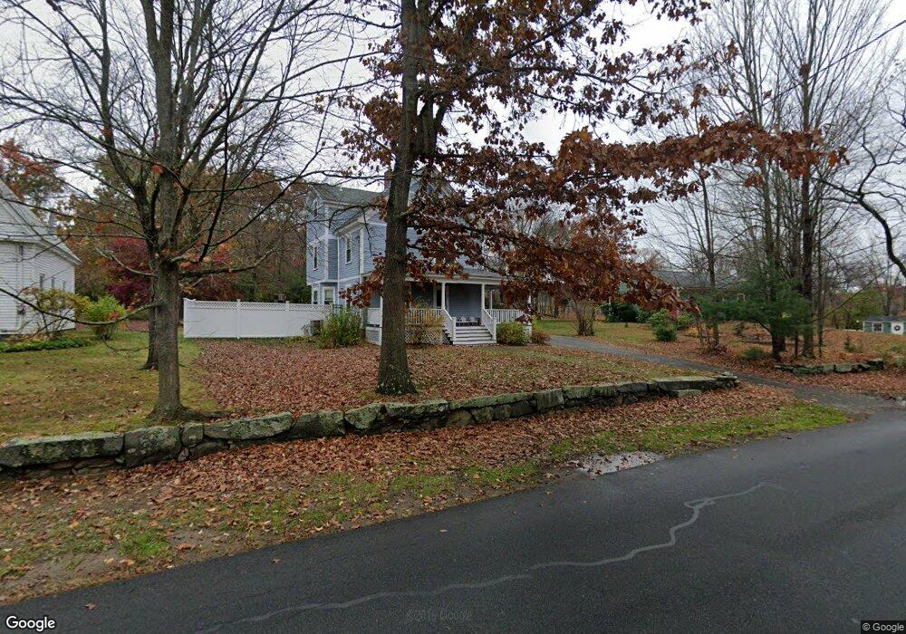
This home is located at 83 Stow St, Acton, MA 01720 and is currently estimated at $776,372, approximately $473 per square foot. 83 Stow St is a home located in Middlesex County with nearby schools including Acton-Boxborough Regional High School and Maynard Knowledge Beginnings.
Ownership History
Date
Name
Owned For
Owner Type
Purchase Details
Closed on
Jun 29, 1998
Sold by
Nothern Denis M and Nothern Bonny C
Bought by
Fay David A and Fay Laura P
Current Estimated Value
Home Financials for this Owner
Home Financials are based on the most recent Mortgage that was taken out on this home.
Original Mortgage
$192,000
Outstanding Balance
$39,599
Interest Rate
7.09%
Mortgage Type
Purchase Money Mortgage
Estimated Equity
$736,773
Purchase Details
Closed on
Sep 2, 1988
Sold by
Rotondo Joseph M
Bought by
Nothern Denis M
Home Financials for this Owner
Home Financials are based on the most recent Mortgage that was taken out on this home.
Original Mortgage
$187,500
Interest Rate
10.38%
Mortgage Type
Purchase Money Mortgage
Create a Home Valuation Report for This Property
The Home Valuation Report is an in-depth analysis detailing your home's value as well as a comparison with similar homes in the area
Home Values in the Area
Average Home Value in this Area
Purchase History
| Date | Buyer | Sale Price | Title Company |
|---|---|---|---|
| Fay David A | $240,000 | -- | |
| Nothern Denis M | $235,000 | -- |
Source: Public Records
Mortgage History
| Date | Status | Borrower | Loan Amount |
|---|---|---|---|
| Open | Nothern Denis M | $192,000 | |
| Previous Owner | Nothern Denis M | $181,000 | |
| Previous Owner | Nothern Denis M | $187,500 |
Source: Public Records
Tax History Compared to Growth
Tax History
| Year | Tax Paid | Tax Assessment Tax Assessment Total Assessment is a certain percentage of the fair market value that is determined by local assessors to be the total taxable value of land and additions on the property. | Land | Improvement |
|---|---|---|---|---|
| 2025 | $10,475 | $610,800 | $313,600 | $297,200 |
| 2024 | $10,182 | $610,800 | $313,600 | $297,200 |
| 2023 | $10,030 | $571,200 | $285,000 | $286,200 |
| 2022 | $9,665 | $496,900 | $247,900 | $249,000 |
| 2021 | $9,336 | $461,500 | $229,500 | $232,000 |
| 2020 | $8,968 | $466,100 | $229,500 | $236,600 |
| 2019 | $8,399 | $433,600 | $229,500 | $204,100 |
| 2018 | $8,316 | $429,100 | $229,500 | $199,600 |
| 2017 | $8,036 | $421,600 | $229,500 | $192,100 |
| 2016 | $8,050 | $418,600 | $229,500 | $189,100 |
| 2015 | $7,790 | $408,900 | $229,500 | $179,400 |
| 2014 | $7,671 | $394,400 | $229,500 | $164,900 |
Source: Public Records
Map
Nearby Homes
- 79 Robbins St
- 19 Railroad St Unit B1
- 19 Railroad St Unit B2
- 19 Railroad St Unit E2
- 84 Central St
- 131 Main St
- 129 Main St
- 129 Main St Unit 129
- 35 Faulkner Hill Rd
- 40 High St
- 4,7,8 Crestwood Ln
- 25 Main St
- 5 Main St
- 128 Audubon Dr
- 32 Brewster Ln
- 101 Prospect St
- 19 Marble Farm Rd Unit 19
- 90 Willow St Unit 1
- 92 Willow St Unit 3
- 4 Loring Ave