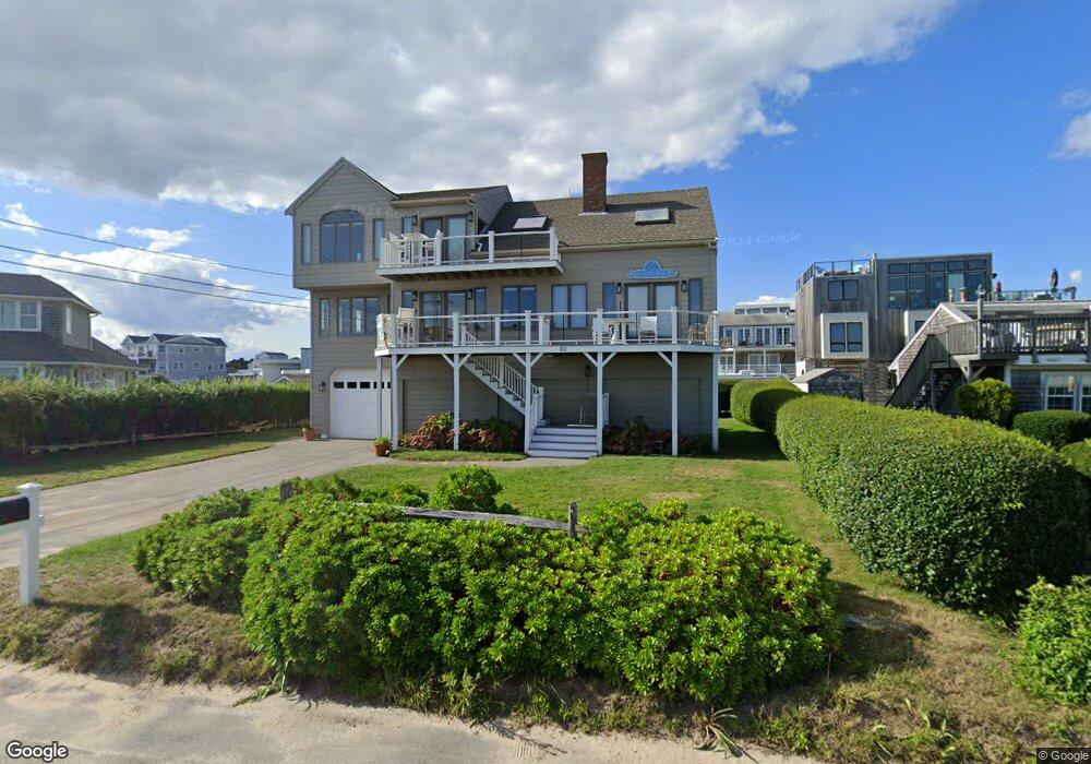
83 Surf Dr Falmouth, MA 02540
Falmouth Village NeighborhoodEstimated Value: $1,812,000 - $2,173,318
3
Beds
2
Baths
2,092
Sq Ft
$971/Sq Ft
Est. Value
About This Home
This home is located at 83 Surf Dr, Falmouth, MA 02540 and is currently estimated at $2,030,580, approximately $970 per square foot. 83 Surf Dr is a home located in Barnstable County with nearby schools including Mullen-Hall School, Lawrence School, and Morse Pond School.
Ownership History
Date
Name
Owned For
Owner Type
Purchase Details
Closed on
May 2, 2025
Sold by
Larracey Thomas M and Larracey Susan A
Bought by
Larracey Ft and Larracey
Current Estimated Value
Purchase Details
Closed on
May 15, 2020
Sold by
Tracy Ashby Falmouth Rt and Tracy
Bought by
Larracey Thomas M and Larracey Susan A
Purchase Details
Closed on
Jan 23, 2008
Sold by
Tracy Sally M
Bought by
Tracy Clayton P and Tracy Sally M
Purchase Details
Closed on
Dec 9, 1994
Sold by
Burke Paul M and Burke Dorothea P
Bought by
Tracy Sally M
Create a Home Valuation Report for This Property
The Home Valuation Report is an in-depth analysis detailing your home's value as well as a comparison with similar homes in the area
Home Values in the Area
Average Home Value in this Area
Purchase History
| Date | Buyer | Sale Price | Title Company |
|---|---|---|---|
| Larracey Ft | -- | None Available | |
| Larracey Ft | -- | None Available | |
| Larracey Thomas M | $1,300,000 | None Available | |
| Larracey Thomas M | $1,300,000 | None Available | |
| Tracy Clayton P | -- | -- | |
| Tracy Clayton P | -- | -- | |
| Tracy Sally M | $260,000 | -- | |
| Tracy Sally M | $260,000 | -- |
Source: Public Records
Tax History Compared to Growth
Tax History
| Year | Tax Paid | Tax Assessment Tax Assessment Total Assessment is a certain percentage of the fair market value that is determined by local assessors to be the total taxable value of land and additions on the property. | Land | Improvement |
|---|---|---|---|---|
| 2025 | $11,837 | $2,016,500 | $1,318,400 | $698,100 |
| 2024 | $11,277 | $1,795,700 | $1,146,400 | $649,300 |
| 2023 | $11,436 | $1,652,600 | $1,146,400 | $506,200 |
| 2022 | $10,132 | $1,258,600 | $820,000 | $438,600 |
| 2021 | $9,693 | $1,140,400 | $784,400 | $356,000 |
| 2020 | $9,184 | $1,069,100 | $713,100 | $356,000 |
| 2019 | $8,914 | $1,041,300 | $713,100 | $328,200 |
| 2018 | $8,867 | $1,031,000 | $713,100 | $317,900 |
| 2017 | $8,721 | $1,022,400 | $713,100 | $309,300 |
| 2016 | $8,557 | $1,022,400 | $713,100 | $309,300 |
| 2015 | $8,373 | $1,022,400 | $713,100 | $309,300 |
| 2014 | $8,309 | $1,019,500 | $713,000 | $306,500 |
Source: Public Records
Map
Nearby Homes
- 15 Hedge Ln
- 65 Walker St
- 71 Main St
- 98 Main St
- 98 Main St Unit 1
- 253 Scranton Ave
- 480 Main St Unit 1
- 30 Katherine Lee Bates Rd
- 9 Fairmount Ave Unit 1
- 9 Fairmount Ave
- 110 Dillingham Ave Unit 322
- 33 Oakwood Ave
- 38 Landfall Unit 38
- 38 Landfall
- 286 Grand Ave Unit 6
- 286 Grand Ave Unit 8
- 286 Grand Ave Unit 4
- 55 Jericho Path
- 87 Oyster Pond Rd
- 22 Alma Rd