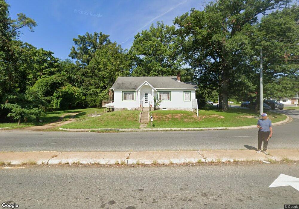
8301 Dangerfield Rd Clinton, MD 20735
Estimated Value: $455,000
--
Bed
1
Bath
1,628
Sq Ft
$279/Sq Ft
Est. Value
About This Home
This home is located at 8301 Dangerfield Rd, Clinton, MD 20735 and is currently priced at $455,000, approximately $279 per square foot. 8301 Dangerfield Rd is a home located in Prince George's County with nearby schools including Melwood Elementary School, James Madison Middle School, and Frederick Douglass High School.
Ownership History
Date
Name
Owned For
Owner Type
Purchase Details
Closed on
Apr 29, 2005
Sold by
Barker Jimmy W and Barker Minyung H
Bought by
New Horizon Gospel Ministries
Current Estimated Value
Purchase Details
Closed on
Mar 2, 2005
Sold by
Barker Jimmy W and Barker Minyung H
Bought by
New Horizon Gospel Ministries
Purchase Details
Closed on
Nov 17, 1998
Sold by
Rubino Dominick and Rose Etal
Bought by
Mike Casey Enterpr Ltd Prtnershp E and Realty Exec Main St Assoc
Create a Home Valuation Report for This Property
The Home Valuation Report is an in-depth analysis detailing your home's value as well as a comparison with similar homes in the area
Home Values in the Area
Average Home Value in this Area
Purchase History
| Date | Buyer | Sale Price | Title Company |
|---|---|---|---|
| New Horizon Gospel Ministries | $386,250 | -- | |
| New Horizon Gospel Ministries | $386,250 | -- | |
| Mike Casey Enterpr Ltd Prtnershp E | $75,000 | -- |
Source: Public Records
Tax History Compared to Growth
Tax History
| Year | Tax Paid | Tax Assessment Tax Assessment Total Assessment is a certain percentage of the fair market value that is determined by local assessors to be the total taxable value of land and additions on the property. | Land | Improvement |
|---|---|---|---|---|
| 2025 | $418 | $622,600 | $428,500 | $194,100 |
| 2024 | $418 | $613,100 | $0 | $0 |
| 2023 | $417 | $603,600 | $0 | $0 |
| 2022 | $0 | $594,100 | $428,500 | $165,600 |
| 2021 | $469 | $575,400 | $0 | $0 |
| 2020 | $7,744 | $556,700 | $0 | $0 |
| 2019 | $4,564 | $538,000 | $428,500 | $109,500 |
| 2018 | $417 | $448,367 | $0 | $0 |
| 2017 | $417 | $358,733 | $0 | $0 |
| 2016 | -- | $269,100 | $0 | $0 |
| 2015 | $4,354 | $269,100 | $0 | $0 |
| 2014 | $4,354 | $269,100 | $0 | $0 |
Source: Public Records
Map
Nearby Homes
- 0 Dangerfield Rd
- 8301 Cedarview Ct
- 8304 Cedarview Ct
- 8400 Cedar Chase Dr
- 8504 Woodyard Rd
- 8518 Cedar Chase Dr
- 8617 Woodyard Rd
- 9007 Oriley Dr
- 7333 Sheila Ln
- 9414 Stream Valley Ln
- 7804 New Ascot Ln
- 9008 Goldfield Place
- 7113 Branchwood Place
- 0 Clinton Vista Ln
- 7904 Mike Shapiro Dr
- 7127 Branchwood Place
- 10104 Dangerfield Rd
- 7205 Mcmillen Dr
- 9004 Eldon Dr
- 7004 Vismanco Ln
- 8301 Woodyard Rd
- 8304 Woodyard Rd
- 8100 Old Alexandria Ferry Rd
- 8228 Woodyard Rd
- 8 Rammer Drive A
- 8324 Woodyard Rd
- 8 Rammer Dr
- 8223 Woodyard Rd
- 8106 Old Alexandria Ferry Rd
- 8219 Woodyard Rd
- 8301 Deborah St Unit LOWER LEVEL
- 8301 Deborah St
- 8326 Woodyard Rd
- 8305 Deborah St
- 8309 Deborah St
- 8313 Deborah St
- 8317 Deborah St
- 8042 Old Alexandria Ferry Rd
- 8300 Deborah St
- 8409 Dangerfield Rd