Estimated Value: $365,857 - $417,000
4
Beds
4
Baths
2,451
Sq Ft
$161/Sq Ft
Est. Value
About This Home
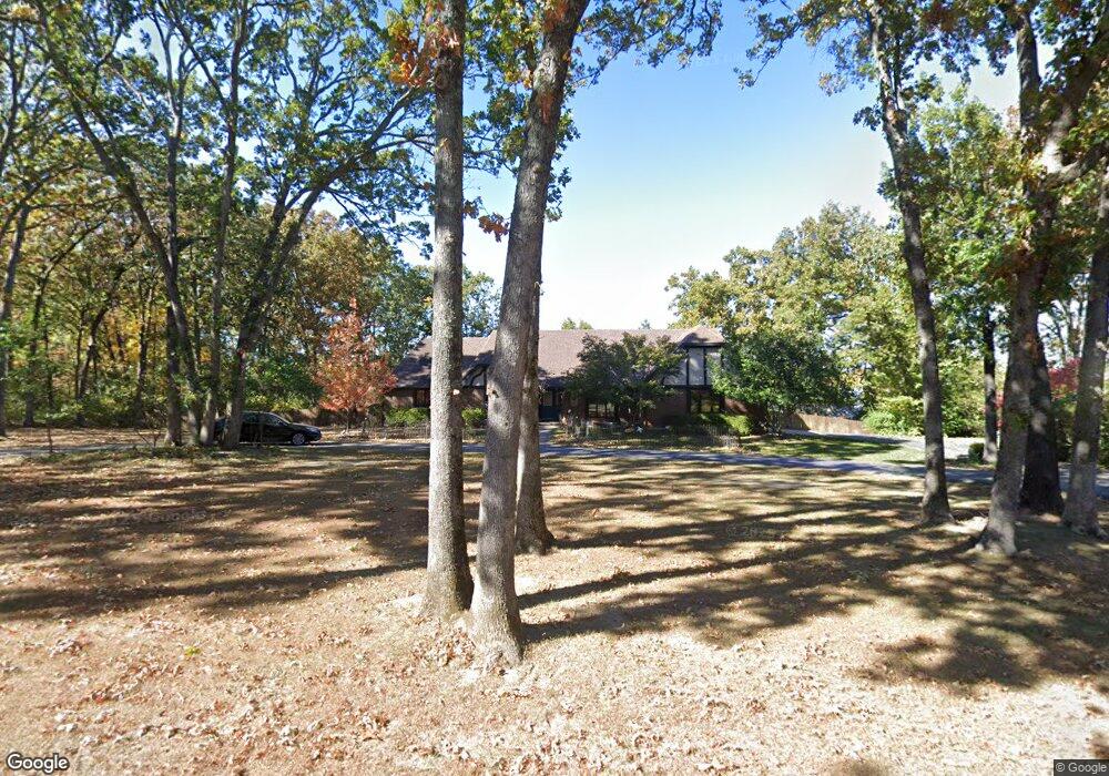
This home is located at 831 Laurel Dr, Rolla, MO 65401 and is currently estimated at $394,286, approximately $160 per square foot. 831 Laurel Dr is a home located in Phelps County with nearby schools including Rolla Junior High School, Rolla Senior High School, and Rolla Seventh-Day Adventist School.
Ownership History
Date
Name
Owned For
Owner Type
Purchase Details
Closed on
Nov 4, 2014
Current Estimated Value
Purchase Details
Closed on
Aug 13, 2013
Purchase Details
Closed on
Mar 29, 2013
Purchase Details
Closed on
Feb 23, 2009
Purchase Details
Closed on
Jan 19, 2005
Purchase Details
Closed on
Mar 21, 2003
Purchase Details
Closed on
Dec 13, 1994
Purchase Details
Closed on
Jan 18, 1980
Create a Home Valuation Report for This Property
The Home Valuation Report is an in-depth analysis detailing your home's value as well as a comparison with similar homes in the area
Home Values in the Area
Average Home Value in this Area
Purchase History
| Date | Buyer | Sale Price | Title Company |
|---|---|---|---|
| -- | $290,000 | -- | |
| -- | -- | -- | |
| -- | -- | -- | |
| -- | -- | -- | |
| -- | -- | -- | |
| -- | -- | -- | |
| -- | -- | -- | |
| -- | -- | -- |
Source: Public Records
Tax History
| Year | Tax Paid | Tax Assessment Tax Assessment Total Assessment is a certain percentage of the fair market value that is determined by local assessors to be the total taxable value of land and additions on the property. | Land | Improvement |
|---|---|---|---|---|
| 2025 | $2,972 | $56,950 | $6,060 | $50,890 |
| 2024 | $2,787 | $51,850 | $5,590 | $46,260 |
| 2023 | $2,805 | $51,850 | $5,590 | $46,260 |
| 2022 | $2,382 | $51,850 | $5,590 | $46,260 |
| 2021 | $2,399 | $51,850 | $5,590 | $46,260 |
| 2020 | $2,172 | $45,820 | $5,590 | $40,230 |
| 2019 | $2,160 | $42,010 | $5,590 | $36,420 |
| 2018 | $1,963 | $42,010 | $5,590 | $36,420 |
| 2017 | $1,959 | $42,010 | $5,590 | $36,420 |
| 2016 | $1,895 | $42,010 | $5,590 | $36,420 |
| 2015 | -- | $42,010 | $5,590 | $36,420 |
| 2014 | -- | $42,010 | $5,590 | $36,420 |
| 2013 | -- | $42,010 | $0 | $0 |
Source: Public Records
Map
Nearby Homes
- 816 Laurel Dr
- 807 Lariat Ln
- Lot 74 B Cedar Hill Ct
- Lot 74 A Cedar Hill Ct
- 814 Oxford Dr
- 1102 Sycamore Dr
- 415 Hutchinson Dr
- 503 Lariat Ln
- 909 Cypress Dr
- 403 Hutchinson Dr
- 45 Mcfarland Dr
- 509 Oak Knoll Rd
- 1011 Carriage Ln
- 38 Johnson Dr
- 687 Salem Ave
- 213 Sunny Dr
- 1132 Leonard Ave
- 1206 Elliott Dr
- 233 Sunny Dr
- 495 Countryside Dr
- 900 Winchester Dr
- 816 Winchester Dr
- 902 Winchester Dr
- 815 Laurel Dr
- 833 Laurel Dr
- 820 Laurel Dr
- 904 Winchester Dr
- 901 Winchester Dr
- 830 Laurel Dr
- 906 Winchester Dr
- 703 Southview Dr
- 903 Winchester Dr
- 813 Winchester Dr
- 901 Laurel Dr
- 900 Laurel Dr
- 805 Marti Dr
- 811 Winchester Dr
- 825 Cambridge Dr
- 908 Winchester Dr
- 905 Winchester Dr
Your Personal Tour Guide
Ask me questions while you tour the home.