Estimated Value: $130,433 - $158,000
2
Beds
1
Bath
1,040
Sq Ft
$144/Sq Ft
Est. Value
About This Home
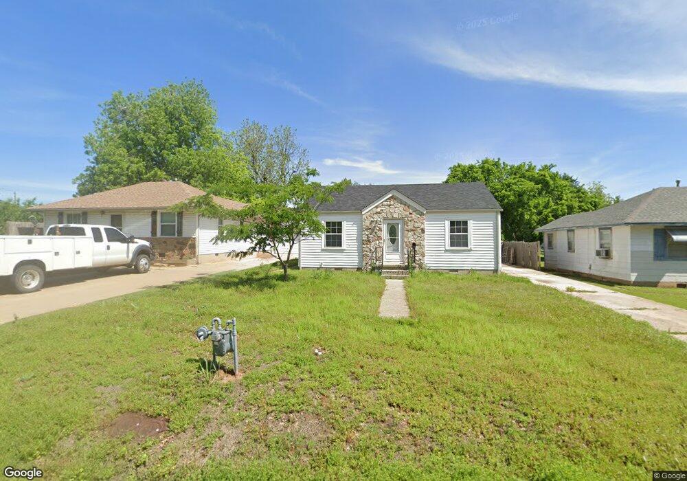
This home is located at 831 Poplar Ave, Yukon, OK 73099 and is currently estimated at $149,608, approximately $143 per square foot. 831 Poplar Ave is a home located in Canadian County with nearby schools including Central Elementary School, Independence Elementary School, and Yukon Middle School.
Ownership History
Date
Name
Owned For
Owner Type
Purchase Details
Closed on
Oct 11, 2023
Sold by
Bm2020 Llc
Bought by
Hurricane Real Estate Llc
Current Estimated Value
Home Financials for this Owner
Home Financials are based on the most recent Mortgage that was taken out on this home.
Original Mortgage
$99,450
Outstanding Balance
$97,784
Interest Rate
7.18%
Mortgage Type
New Conventional
Estimated Equity
$51,824
Purchase Details
Closed on
Jul 17, 2023
Sold by
Mckinnon Home Buyers Llc
Bought by
Bm2020 Llc
Purchase Details
Closed on
Nov 27, 2009
Sold by
Rosales Lawanda Ardina
Bought by
Brooks Johnny G and Brooks Esperanza
Home Financials for this Owner
Home Financials are based on the most recent Mortgage that was taken out on this home.
Original Mortgage
$31,664
Interest Rate
8.9%
Mortgage Type
Unknown
Create a Home Valuation Report for This Property
The Home Valuation Report is an in-depth analysis detailing your home's value as well as a comparison with similar homes in the area
Home Values in the Area
Average Home Value in this Area
Purchase History
| Date | Buyer | Sale Price | Title Company |
|---|---|---|---|
| Hurricane Real Estate Llc | -- | None Listed On Document | |
| Bm2020 Llc | $85,000 | Oklahoma Prime Title & Escrow | |
| Mckinnon Home Buyers Llc | $77,500 | Oklahoma Prime Title & Escrow | |
| Brooks Johnny G | -- | Agt |
Source: Public Records
Mortgage History
| Date | Status | Borrower | Loan Amount |
|---|---|---|---|
| Open | Hurricane Real Estate Llc | $99,450 | |
| Previous Owner | Brooks Johnny Glen Dale | $41,000 | |
| Previous Owner | Brooks Johnny G | $36,348 | |
| Previous Owner | Brooks Johnny G | $31,664 |
Source: Public Records
Tax History Compared to Growth
Tax History
| Year | Tax Paid | Tax Assessment Tax Assessment Total Assessment is a certain percentage of the fair market value that is determined by local assessors to be the total taxable value of land and additions on the property. | Land | Improvement |
|---|---|---|---|---|
| 2024 | $818 | $12,455 | $3,360 | $9,095 |
| 2023 | $818 | $7,550 | $1,544 | $6,006 |
| 2022 | $783 | $7,190 | $1,384 | $5,806 |
| 2021 | $748 | $6,848 | $1,384 | $5,464 |
| 2020 | $703 | $6,522 | $1,383 | $5,139 |
| 2019 | $672 | $6,211 | $1,382 | $4,829 |
| 2018 | $642 | $5,916 | $1,382 | $4,534 |
| 2017 | $612 | $5,635 | $1,381 | $4,254 |
| 2016 | $583 | $5,634 | $1,380 | $4,254 |
| 2015 | $536 | $5,111 | $1,380 | $3,731 |
| 2014 | $536 | $4,867 | $1,380 | $3,487 |
Source: Public Records
Map
Nearby Homes
- 600 S 8th St
- 11325 SW 34th Terrace
- 601 S 8th St
- 705 Yukon Ave
- 417 Garth Brooks Blvd
- 1016 Maple Ave
- 624 Frisco Ridge Rd
- 9116 Anaum Ln
- 621 Yukon Ave
- 616 Kingston Dr
- 1101 W Main St
- 1004 Cedar Ave
- 3509 Sawtooth Ridge Dr
- 3608 Northover Ridge Dr
- 12033 SW 31st St
- 11020 SW 34th Terrace
- 10401 NW 33rd St
- 4601 Grassland Dr
- 11817 Corie Nicole Ln
- 740 Kingston Dr