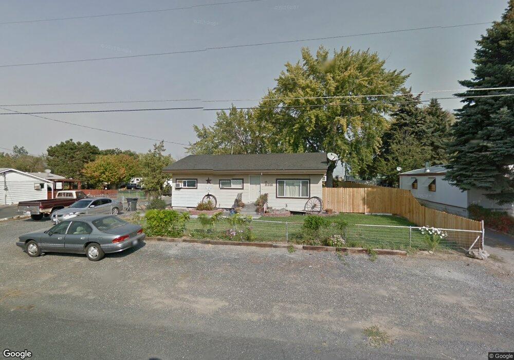
8316 Terminal St NE Moses Lake, WA 98837
Estimated Value: $243,000 - $332,652
4
Beds
1
Bath
1,920
Sq Ft
$149/Sq Ft
Est. Value
About This Home
This home is located at 8316 Terminal St NE, Moses Lake, WA 98837 and is currently estimated at $285,663, approximately $148 per square foot. 8316 Terminal St NE is a home located in Grant County with nearby schools including Park Orchard Elementary School, Frontier Middle School, and Moses Lake High School.
Ownership History
Date
Name
Owned For
Owner Type
Purchase Details
Closed on
Dec 5, 2008
Sold by
Brooks Robert and Brooks Margaret Louise
Bought by
Trowbridge Suzanne L
Current Estimated Value
Home Financials for this Owner
Home Financials are based on the most recent Mortgage that was taken out on this home.
Original Mortgage
$112,244
Outstanding Balance
$75,386
Interest Rate
6.47%
Mortgage Type
Purchase Money Mortgage
Estimated Equity
$210,277
Create a Home Valuation Report for This Property
The Home Valuation Report is an in-depth analysis detailing your home's value as well as a comparison with similar homes in the area
Home Values in the Area
Average Home Value in this Area
Purchase History
| Date | Buyer | Sale Price | Title Company |
|---|---|---|---|
| Trowbridge Suzanne L | $128,300 | Frontier Title & Escrow |
Source: Public Records
Mortgage History
| Date | Status | Borrower | Loan Amount |
|---|---|---|---|
| Open | Trowbridge Suzanne L | $112,244 |
Source: Public Records
Tax History Compared to Growth
Tax History
| Year | Tax Paid | Tax Assessment Tax Assessment Total Assessment is a certain percentage of the fair market value that is determined by local assessors to be the total taxable value of land and additions on the property. | Land | Improvement |
|---|---|---|---|---|
| 2024 | $2,316 | $194,696 | $35,175 | $159,521 |
| 2023 | $2,326 | $172,570 | $35,175 | $137,395 |
| 2022 | $2,107 | $172,570 | $35,175 | $137,395 |
| 2021 | $1,889 | $172,570 | $35,175 | $137,395 |
| 2020 | $1,952 | $149,520 | $35,175 | $114,345 |
| 2019 | $2,015 | $137,095 | $25,075 | $112,020 |
| 2018 | $2,051 | $128,145 | $25,075 | $103,070 |
| 2017 | $2,001 | $128,145 | $25,075 | $103,070 |
| 2016 | $1,709 | $107,000 | $25,000 | $82,000 |
| 2013 | -- | $93,335 | $25,000 | $68,335 |
Source: Public Records
Map
Nearby Homes
- 8334 8336 Terminal St NE
- 8654 Broad St NE
- 4815 Airway Dr NE Unit 12
- 4815 Airway Dr NE Unit 105
- 0 TBD Broad St NE
- 4126 Fairview Place NE
- 8558 Arlene Rd NE
- 8630 Hillcrest Dr NE
- 4235 Moon Dr NE
- 7887 Dahl Rd NE
- 1019 Redwood Rd
- 4886 Ray Rd NE
- 1030 Redwood Rd
- 1101 Redwood Rd
- 1113 Redwood Rd
- 1105 Redwood Rd
- 1903 Hickory Rd
- 1102 Redwood Rd
- 2043 N Oak Rd
- 1109 Redwood Rd
- 8336 Terminal St NE
- 8298 Terminal St NE
- 8294 Terminal St NE
- 8334 Terminal St NE
- 8350 Terminal St NE
- 8335 Terminal St NE
- 8280 Terminal St NE
- 8315 Terminal St NE
- 8297 Terminal St NE
- 8368 Terminal St NE Unit 8362
- 8362 Terminal St NE
- 8349 Terminal St NE
- 8279 Terminal St NE
- 8264 Terminal St NE
- 8315 Broad St NE
- 8339 Broad St NE
- 8285 Broad St NE
- 8271 Broad St NE
- 8353 Broad St NE
- 8367 Terminal St NE