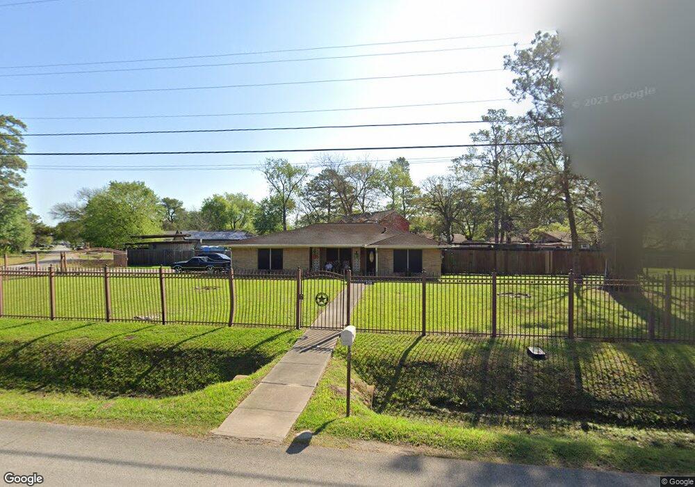
8318 Shady Dr Houston, TX 77016
Trinity-Houston Gardens NeighborhoodEstimated Value: $231,000 - $354,344
3
Beds
2
Baths
2,160
Sq Ft
$142/Sq Ft
Est. Value
About This Home
This home is located at 8318 Shady Dr, Houston, TX 77016 and is currently estimated at $305,836, approximately $141 per square foot. 8318 Shady Dr is a home located in Harris County with nearby schools including Felix Cook Jr. Elementary School, Key Middle, and Kashmere High School.
Ownership History
Date
Name
Owned For
Owner Type
Purchase Details
Closed on
Oct 7, 2004
Sold by
Hawthorne Michael
Bought by
Johnson Anthony
Current Estimated Value
Purchase Details
Closed on
Sep 22, 2004
Sold by
Deutsche Bank National Trust Co
Bought by
Hawthorne Michael and Johnson Anthony
Purchase Details
Closed on
May 4, 2004
Sold by
Trishell Elouise Moore and Trishell Elouise Moore J C
Bought by
Deutsche Bank National Trust Co and Asset Backed Funding Corp
Purchase Details
Closed on
Nov 30, 2000
Sold by
Trishell Elouise Moore and Moore Elouise
Bought by
Trishell J C
Home Financials for this Owner
Home Financials are based on the most recent Mortgage that was taken out on this home.
Original Mortgage
$51,000
Interest Rate
7.72%
Mortgage Type
Credit Line Revolving
Create a Home Valuation Report for This Property
The Home Valuation Report is an in-depth analysis detailing your home's value as well as a comparison with similar homes in the area
Home Values in the Area
Average Home Value in this Area
Purchase History
| Date | Buyer | Sale Price | Title Company |
|---|---|---|---|
| Johnson Anthony | -- | -- | |
| Hawthorne Michael | -- | First American Title | |
| Deutsche Bank National Trust Co | $75,913 | -- | |
| Trishell J C | -- | Texas American Title Company |
Source: Public Records
Mortgage History
| Date | Status | Borrower | Loan Amount |
|---|---|---|---|
| Previous Owner | Trishell J C | $51,000 |
Source: Public Records
Tax History Compared to Growth
Tax History
| Year | Tax Paid | Tax Assessment Tax Assessment Total Assessment is a certain percentage of the fair market value that is determined by local assessors to be the total taxable value of land and additions on the property. | Land | Improvement |
|---|---|---|---|---|
| 2025 | $3,595 | $428,597 | $162,764 | $265,833 |
| 2024 | $3,595 | $368,581 | $153,463 | $215,118 |
| 2023 | $3,595 | $385,219 | $139,512 | $245,707 |
| 2022 | $4,844 | $317,600 | $116,260 | $201,340 |
| 2021 | $5,025 | $217,101 | $58,130 | $158,971 |
| 2020 | $4,746 | $196,000 | $58,130 | $137,870 |
| 2019 | $4,593 | $208,807 | $58,130 | $150,677 |
| 2018 | $3,055 | $165,000 | $52,317 | $112,683 |
| 2017 | $4,172 | $175,099 | $52,317 | $122,782 |
| 2016 | $4,537 | $179,433 | $52,317 | $127,116 |
| 2015 | -- | $165,000 | $52,317 | $112,683 |
| 2014 | -- | $171,966 | $52,317 | $119,649 |
Source: Public Records
Map
Nearby Homes
- 8312 Lanewood Dr
- 8218 Bertwood St
- 8420 Lanewood Dr
- 8502 Shady Dr
- 6908 S Hall St
- 0 Shreveport Blvd
- 8514 Spaulding St
- 6606 Weaver Rd
- 6838 Carothers St
- 6842 Carothers St
- 7002 S Hall St
- 7910 Allwood St
- 6705 Roanoke St
- 6719 Roanoke St
- 8634 Allwood St
- 8700 Lanewood Dr
- 7010 S Hall St
- 6320 Laura Koppe Rd
- 8636 Allwood St
- 8598 Hoffman St
- 8217 Spaulding St
- 8317 Shady Dr
- 8225 Spaulding St
- 8306 Lanewood Dr
- 8321 Shady Dr
- 8231 Spaulding St
- 8313 Shady Dr
- 8213 Spaulding St
- 8309 Shady Dr
- 8406 Shady Dr
- 8407 Shady Dr
- 8305 Spaulding St
- 8305 Shady Dr
- 8314 Lanewood Dr
- 8306 Bertwood St
- 8302 Bertwood St
- 8310 Bertwood St
- 8222 Bertwood St
- 8309 Spaulding St
- 8327 Lanewood Dr