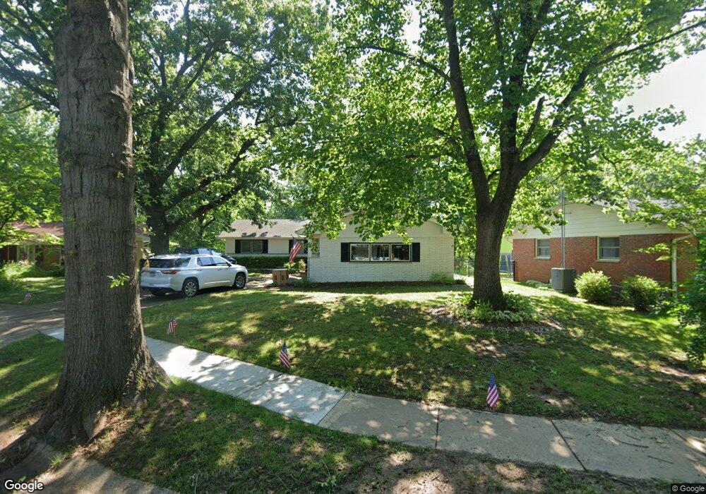
832 Independence Ridge None Springfield, IL 62702
Estimated Value: $254,000 - $333,000
--
Bed
3
Baths
--
Sq Ft
0.49
Acres
About This Home
This home is located at 832 Independence Ridge None, Springfield, IL 62702 and is currently estimated at $300,385. 832 Independence Ridge None is a home located in Sangamon County with nearby schools including Dubois Elementary School, U.S. Grant Middle School, and Springfield High School.
Ownership History
Date
Name
Owned For
Owner Type
Purchase Details
Closed on
Sep 7, 2023
Sold by
King Zachary D
Bought by
Harwell Alan and Harwell Christine
Current Estimated Value
Purchase Details
Closed on
May 23, 2023
Sold by
King Zachary D
Bought by
Harwell Alan and Harwell Christine
Home Financials for this Owner
Home Financials are based on the most recent Mortgage that was taken out on this home.
Original Mortgage
$199,363
Interest Rate
6.81%
Mortgage Type
New Conventional
Purchase Details
Closed on
Dec 26, 2019
Sold by
Hill Julie A
Bought by
King Zachary D
Home Financials for this Owner
Home Financials are based on the most recent Mortgage that was taken out on this home.
Original Mortgage
$201,331
Interest Rate
3.38%
Mortgage Type
VA
Create a Home Valuation Report for This Property
The Home Valuation Report is an in-depth analysis detailing your home's value as well as a comparison with similar homes in the area
Home Values in the Area
Average Home Value in this Area
Purchase History
| Date | Buyer | Sale Price | Title Company |
|---|---|---|---|
| Harwell Alan | $265,000 | None Listed On Document | |
| Harwell Alan | $265,000 | None Listed On Document | |
| King Zachary D | $194,900 | Chicago Title |
Source: Public Records
Mortgage History
| Date | Status | Borrower | Loan Amount |
|---|---|---|---|
| Previous Owner | Harwell Alan | $199,363 | |
| Previous Owner | King Zachary D | $201,331 |
Source: Public Records
Tax History Compared to Growth
Tax History
| Year | Tax Paid | Tax Assessment Tax Assessment Total Assessment is a certain percentage of the fair market value that is determined by local assessors to be the total taxable value of land and additions on the property. | Land | Improvement |
|---|---|---|---|---|
| 2024 | $6,043 | $77,950 | $10,872 | $67,078 |
| 2023 | $5,765 | $71,201 | $9,931 | $61,270 |
| 2022 | $5,515 | $67,540 | $9,420 | $58,120 |
| 2021 | $5,312 | $65,011 | $9,067 | $55,944 |
| 2020 | $5,735 | $65,109 | $9,081 | $56,028 |
| 2019 | $4,850 | $55,908 | $9,049 | $46,859 |
| 2018 | $3,750 | $55,380 | $9,006 | $46,374 |
| 2017 | $3,660 | $54,664 | $8,890 | $45,774 |
| 2016 | $3,575 | $53,866 | $8,760 | $45,106 |
| 2015 | $3,529 | $53,222 | $8,655 | $44,567 |
| 2014 | $3,296 | $52,878 | $8,599 | $44,279 |
| 2013 | $3,222 | $50,769 | $8,598 | $42,171 |
Source: Public Records
Map
Nearby Homes
- 832 Independence Ridge
- 24 Westwood Terrace Unit 1
- 700 Country Meadows Dr
- 2553 Chapel Hill Dr
- 2491 W Washington St
- 2011 W Jefferson St
- 105 Timberridge Dr
- 200 N Durkin Dr
- 1921 Jeanette Ln Unit 2
- 2102 W Jefferson St
- 1910 Jeanette Ln Unit 2
- 2929 Cider Mill Ln
- 160 S Durkin Dr Unit 4
- 804 Fairfax Ct
- 325 Cartwright Dr
- 308 S Oxford Rd
- 22 Babiak Ln
- 55 Trailridge Ln
- 313 S Durkin Dr Unit 313
- 10 Royal Rd
- 824 Independence Ridge
- 840 Independence Ridge
- 816 Independence Ridge
- 831 Independence Ridge
- 0 Independence Ridge
- 848 Independence Ridge
- 808 Independence Ridge
- 839 Independence Ridge
- 815 Independence Ridge
- 2429 Churchill Rd
- 800 Independence Ridge
- 809 Independence Ridge
- 856 Independence Ridge
- 855 Independence Ridge
- 830 Randolph Ct
- 824 Randolph Ct
- 863 Independence Ridge
- 2505 Churchill Rd
- 2500 Churchill Rd
- 2509 Churchill Rd