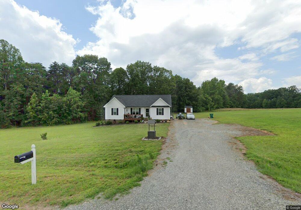
832 Simpson Rd Stokesdale, NC 27357
Estimated Value: $327,360 - $358,000
3
Beds
2
Baths
1,398
Sq Ft
$244/Sq Ft
Est. Value
About This Home
This home is located at 832 Simpson Rd, Stokesdale, NC 27357 and is currently estimated at $341,340, approximately $244 per square foot. 832 Simpson Rd is a home with nearby schools including Huntsville Elementary School, John W. Dillard Academy, and Western Rockingham Middle School.
Ownership History
Date
Name
Owned For
Owner Type
Purchase Details
Closed on
Apr 17, 2020
Sold by
B S & J Builders Inc
Bought by
Day Cory B and Day Kyrstin Tyneeta
Current Estimated Value
Home Financials for this Owner
Home Financials are based on the most recent Mortgage that was taken out on this home.
Original Mortgage
$181,717
Outstanding Balance
$160,673
Interest Rate
3.3%
Mortgage Type
New Conventional
Estimated Equity
$180,667
Purchase Details
Closed on
Jan 8, 2019
Sold by
Merritt Douglas E and Merritt Anna H
Bought by
B S & J Builders Inc
Create a Home Valuation Report for This Property
The Home Valuation Report is an in-depth analysis detailing your home's value as well as a comparison with similar homes in the area
Purchase History
| Date | Buyer | Sale Price | Title Company |
|---|---|---|---|
| Day Cory B | $180,000 | None Available | |
| B S & J Builders Inc | $45,000 | Chicago Title Insurance Co |
Source: Public Records
Mortgage History
| Date | Status | Borrower | Loan Amount |
|---|---|---|---|
| Open | Day Cory B | $181,717 |
Source: Public Records
Tax History
| Year | Tax Paid | Tax Assessment Tax Assessment Total Assessment is a certain percentage of the fair market value that is determined by local assessors to be the total taxable value of land and additions on the property. | Land | Improvement |
|---|---|---|---|---|
| 2025 | $1,994 | $286,907 | $28,250 | $258,657 |
| 2024 | $1,899 | $286,907 | $28,250 | $258,657 |
| 2023 | $1,899 | $164,743 | $20,815 | $143,928 |
| 2022 | $1,285 | $164,743 | $20,815 | $143,928 |
| 2021 | $1,285 | $164,743 | $20,815 | $143,928 |
| 2020 | $162 | $20,815 | $20,815 | $0 |
Source: Public Records
Map
Nearby Homes
- 1713 Gideon Grove Church Rd
- 1325 Simpson Rd
- 139 Knight Farm Rd
- 147 Knight Farm Rd
- 143 Knight Farm Rd
- 109 Knight Farm Rd
- 115 Knight Farm Rd
- 193 Windward Dr
- 181 Woodsong Dr
- 135 Hilton Rd
- 0 Starboard Ct
- 192.74 AC Us Highway 220
- 162 Albert Rd
- 198 Twin Creeks Dr
- 266 Mount Zion Church Rd
- 215 Northcrest Dr
- 173 Carlton Rd
- 485 Saddlebred Loop
- 147 Northcrest Dr
- 423 Mount Zion Church Rd
- 816 Simpson Rd
- 1382 Gideon Grove Church Rd
- 739 Simpson Rd
- 18.34 +/- AC Simpson Rd
- 382 Cartwright Dr
- 1516 Gideon Grove Church Rd
- 1644 Gideon Grove Church Rd
- 1590 Gideon Grove Church Rd
- 663 Simpson Rd
- 1614 Gideon Grove Church Rd
- 342 Cartwright Dr
- 996 Simpson Rd
- 1640 Gideon Grove Church Rd
- 660 Simpson Rd
- 301 Cartwright Dr
- 1672 Gideon Grove Church Rd
- 1635 Gideon Grove Church Rd
- 1367 Gideon Grove Church Rd
- 1653 Gideon Grove Church Rd
- 14.42 +/- AC Gideon Grove Church Rd
Your Personal Tour Guide
Ask me questions while you tour the home.