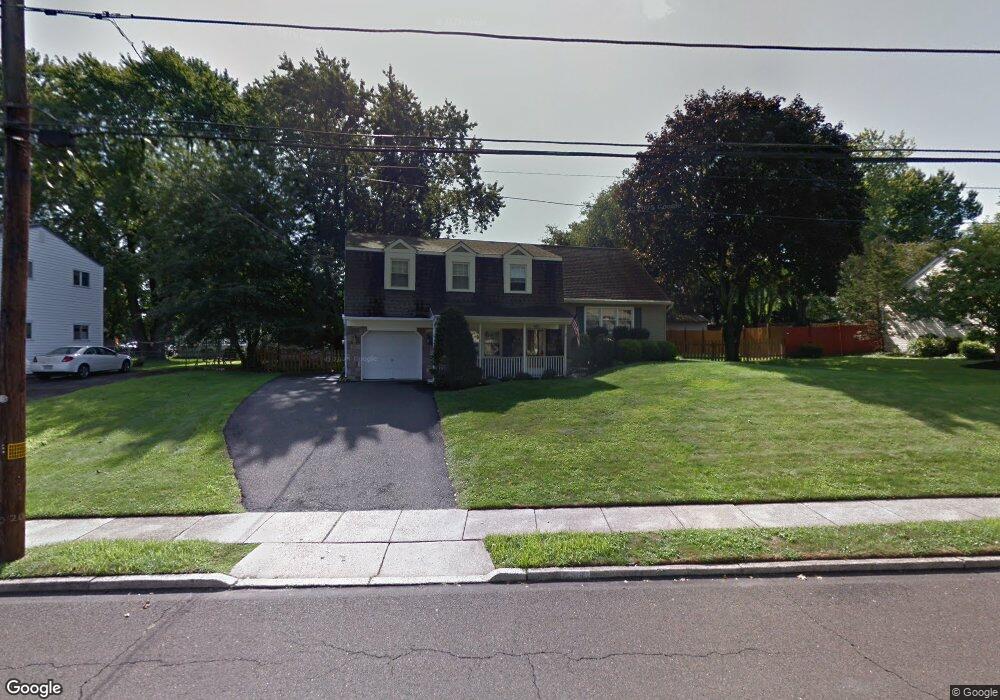
835 Phillips Rd Warminster, PA 18974
Estimated Value: $476,000 - $527,000
3
Beds
2
Baths
1,741
Sq Ft
$288/Sq Ft
Est. Value
About This Home
This home is located at 835 Phillips Rd, Warminster, PA 18974 and is currently estimated at $501,498, approximately $288 per square foot. 835 Phillips Rd is a home located in Bucks County with nearby schools including McDonald Elementary School, Log College Middle School, and William Tennent High School.
Ownership History
Date
Name
Owned For
Owner Type
Purchase Details
Closed on
Jan 31, 1997
Sold by
Hibberd John A and Hibberd Amy J
Bought by
Molko Curtis W and Molko Michelle D
Current Estimated Value
Home Financials for this Owner
Home Financials are based on the most recent Mortgage that was taken out on this home.
Original Mortgage
$98,450
Outstanding Balance
$11,140
Interest Rate
7.57%
Estimated Equity
$490,358
Purchase Details
Closed on
Nov 26, 1990
Bought by
Hibberd John A Jr and Hibberd Amy J
Create a Home Valuation Report for This Property
The Home Valuation Report is an in-depth analysis detailing your home's value as well as a comparison with similar homes in the area
Home Values in the Area
Average Home Value in this Area
Purchase History
| Date | Buyer | Sale Price | Title Company |
|---|---|---|---|
| Molko Curtis W | $147,000 | -- | |
| Hibberd John A Jr | $152,500 | -- |
Source: Public Records
Mortgage History
| Date | Status | Borrower | Loan Amount |
|---|---|---|---|
| Open | Molko Curtis W | $98,450 |
Source: Public Records
Tax History
| Year | Tax Paid | Tax Assessment Tax Assessment Total Assessment is a certain percentage of the fair market value that is determined by local assessors to be the total taxable value of land and additions on the property. | Land | Improvement |
|---|---|---|---|---|
| 2025 | $5,825 | $27,600 | $5,240 | $22,360 |
| 2024 | $5,825 | $27,600 | $5,240 | $22,360 |
| 2023 | $5,646 | $27,600 | $5,240 | $22,360 |
| 2022 | $5,525 | $27,600 | $5,240 | $22,360 |
| 2021 | $5,397 | $27,600 | $5,240 | $22,360 |
| 2020 | $5,321 | $27,600 | $5,240 | $22,360 |
| 2019 | $5,038 | $27,600 | $5,240 | $22,360 |
| 2018 | $4,918 | $27,600 | $5,240 | $22,360 |
| 2017 | $4,774 | $27,600 | $5,240 | $22,360 |
| 2016 | $4,774 | $27,600 | $5,240 | $22,360 |
| 2015 | $4,669 | $27,600 | $5,240 | $22,360 |
| 2014 | $4,669 | $27,600 | $5,240 | $22,360 |
Source: Public Records
Map
Nearby Homes
- 854 Phillips Rd
- 641 Whittier Dr
- 632 Longfellow Ct
- 630 Whittier Dr
- 631 Whittier Dr
- 505 Orchard Ave
- 737 Tennyson Dr
- 745 Tennyson Dr
- 786 Boxwood Dr
- 422 Brandywine Ct Unit YV422
- 909 Holden Ct
- Lot 15 Kennedy Way
- 0 York Rd
- 11 Lincoln Ave
- 942 Stein Ct
- 746 Spruce Rd
- 202 Strawberry Ct Unit 249
- 403 Silver Oak Ct
- 992 Jamison St
- 130 E Street Rd
- 839 Phillips Rd
- 831 Phillips Rd
- 926 Mearns Rd
- 843 Phillips Rd
- 942 Mearns Rd
- 838 Phillips Rd
- 936 Mearns Rd
- 827 Phillips Rd
- 842 Phillips Rd
- 950 Mearns Rd
- 918 Mearns Rd
- 832 Phillips Rd
- 828 Phillips Rd
- 847 Phillips Rd
- 846 Phillips Rd
- 958 Mearns Rd
- 823 Phillips Rd
- 910 Mearns Rd
- 850 Phillips Rd
- 505 Brook Ln
Your Personal Tour Guide
Ask me questions while you tour the home.