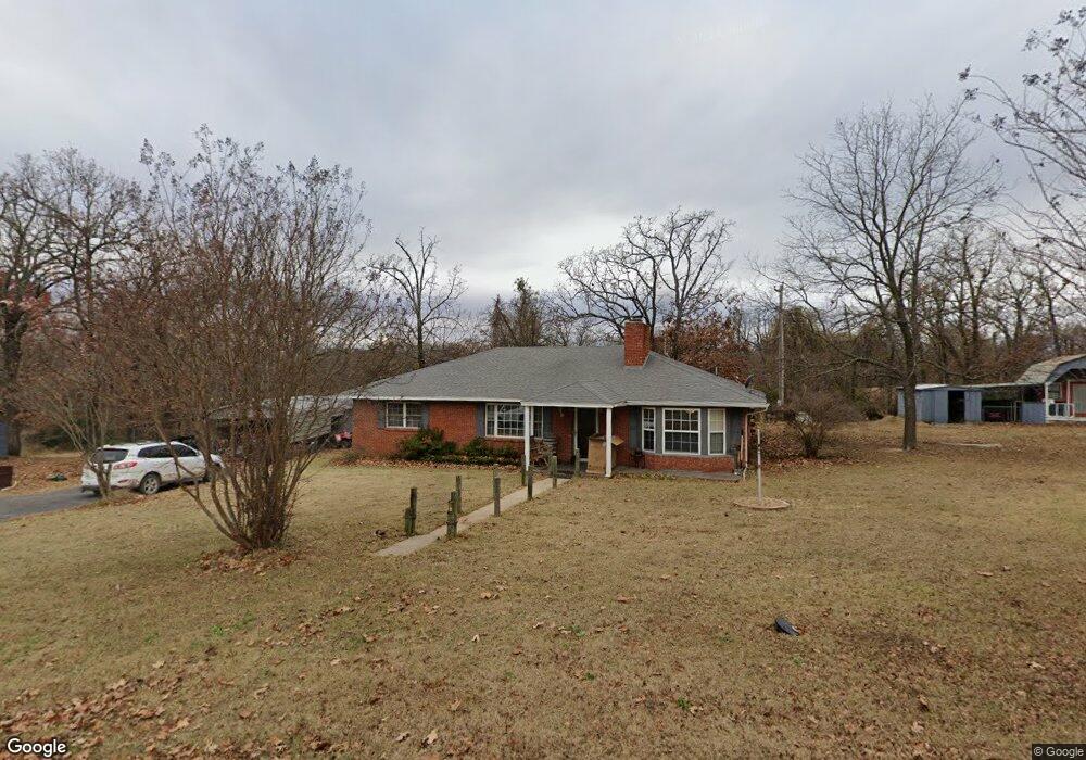
835 Shawnee Dr Eufaula, OK 74432
Estimated Value: $255,001 - $381,000
2
Beds
2
Baths
2,040
Sq Ft
$150/Sq Ft
Est. Value
About This Home
This home is located at 835 Shawnee Dr, Eufaula, OK 74432 and is currently estimated at $306,000, approximately $150 per square foot. 835 Shawnee Dr is a home located in McIntosh County with nearby schools including Eufaula Elementary School, Eufaula Middle School, and Eufaula High School.
Ownership History
Date
Name
Owned For
Owner Type
Purchase Details
Closed on
Mar 30, 2023
Sold by
Dewayne Whitehouse and Kathryn Mary
Bought by
Lay Joshua and Miller Edward Kothe
Current Estimated Value
Home Financials for this Owner
Home Financials are based on the most recent Mortgage that was taken out on this home.
Original Mortgage
$199,500
Outstanding Balance
$191,893
Interest Rate
6.32%
Mortgage Type
New Conventional
Estimated Equity
$114,107
Purchase Details
Closed on
Dec 31, 2013
Sold by
Winkle Darrell C and Winkle Shir
Bought by
Whitehouse Dannie Dewayn
Create a Home Valuation Report for This Property
The Home Valuation Report is an in-depth analysis detailing your home's value as well as a comparison with similar homes in the area
Home Values in the Area
Average Home Value in this Area
Purchase History
We collect this data history from publicly available records. To have your information removed, we recommend requesting removal directly through your county’s website.
| Date | Buyer | Sale Price | Title Company |
|---|---|---|---|
| Lay Joshua | $210,000 | Old Republic National Title | |
| Lay Joshua | $210,000 | Old Republic National Title | |
| Whitehouse Dannie Dewayn | $139,500 | -- | |
| Whitehouse Dannie Dewayn | $139,500 | -- |
Source: Public Records
Mortgage History
We collect this data history from publicly available records. To have your information removed, we recommend requesting removal directly through your county’s website.
| Date | Status | Borrower | Loan Amount |
|---|---|---|---|
| Open | Lay Joshua | $199,500 |
Source: Public Records
Tax History
| Year | Tax Paid | Tax Assessment Tax Assessment Total Assessment is a certain percentage of the fair market value that is determined by local assessors to be the total taxable value of land and additions on the property. | Land | Improvement |
|---|---|---|---|---|
| 2025 | $2,003 | $22,889 | $4,400 | $18,489 |
| 2024 | $2,015 | $23,062 | $4,400 | $18,662 |
| 2023 | $2,015 | $10,364 | $2,640 | $7,724 |
| 2022 | $763 | $9,203 | $1,980 | $7,223 |
| 2021 | $736 | $8,764 | $1,980 | $6,784 |
| 2020 | $736 | $8,764 | $1,980 | $6,784 |
| 2019 | $1,017 | $12,009 | $1,980 | $10,029 |
| 2018 | $1,000 | $12,008 | $1,980 | $10,028 |
| 2017 | $1,008 | $12,102 | $1,980 | $10,122 |
| 2016 | $969 | $11,578 | $1,732 | $9,846 |
| 2015 | $911 | $11,026 | $1,100 | $9,926 |
| 2014 | $905 | $11,026 | $1,100 | $9,926 |
Source: Public Records
Map
Nearby Homes
- 4 E 1200
- 6 E 1200
- 229 Seminole Dr
- 230 Seminole Dr
- 0 Choctaw Dr Unit 2613568
- 0 Choctaw Dr Unit 2613565
- 0 Quapaw Dr
- 8 E 1200
- 589 Mohawk
- 989 Sequoyah Dr
- 721 Mohawk Dr
- 120290 S 4182 Rd
- 0 Dogwood Ln
- 120347 S 4186 Rd
- 0 Comanche Dr Unit OKC1219168
- 120467 S 4186 Rd
- 336 Lakeshore Dr Unit 336
- 330 Lakeshore Dr Unit 330
- 7020 Lakeshore Dr Unit 20
- 701 Lakeshore Dr
- 835 Shawnee Dr
- 819 Shawnee Dr
- 0 Shawnee Rd
- 822 Shawnee Dr
- 709 Shawnee Dr
- 255 Rr 5
- 714 Choctaw Dr
- 714 Choctaw Dr
- 723 Seminole Dr
- 709 Choctaw Dr
- 709 Mohawk Dr
- 0 Quapaw St Unit 2507922
- 0 Quapaw St Unit 2427488
- 0 Quapaw St Unit 2400266
- 0 Quapaw St Unit 2320777
- 0 Quapaw St Unit 1807538
- 0 Quapaw St Unit 1807528
- 20513 1200 St
- 708 Quapaw Dr
- 0 Mohawk Dr
Your Personal Tour Guide
Ask me questions while you tour the home.