
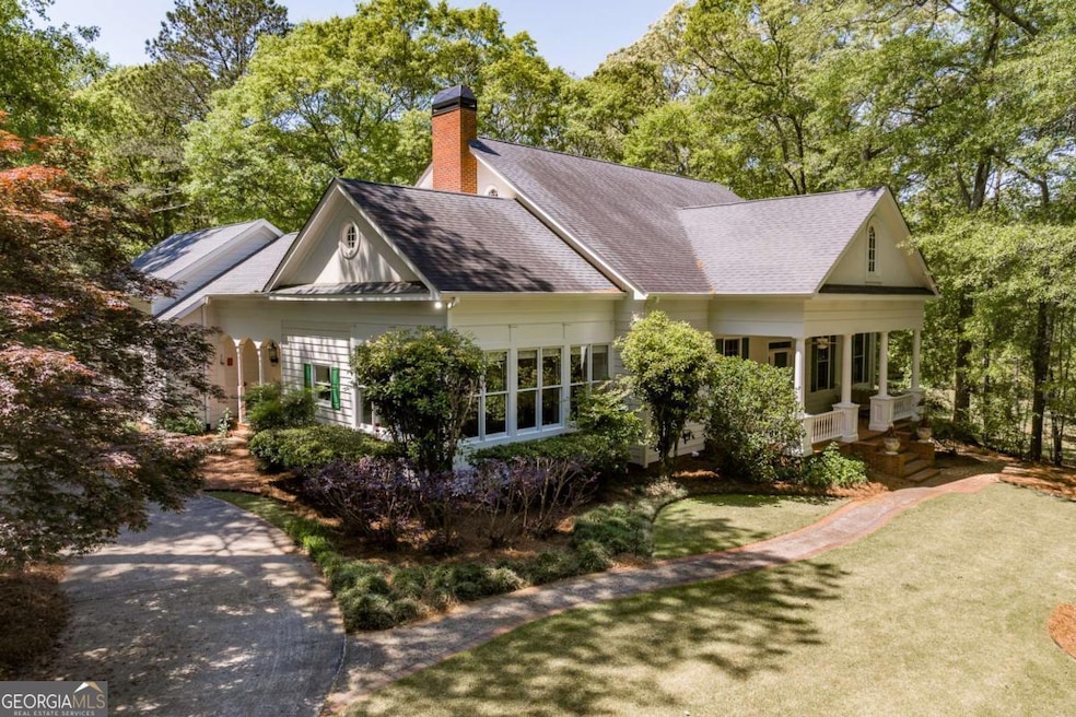

835 Timothy Rd Athens, GA 30606
Tanglewood NeighborhoodEstimated payment $4,978/month
Total Views
9,126
4
Beds
3.5
Baths
3,750
Sq Ft
$233
Price per Sq Ft
Highlights
- Hot Property
- 2 Acre Lot
- Freestanding Bathtub
- Clarke Central High School Rated A-
- Private Lot
- Partially Wooded Lot
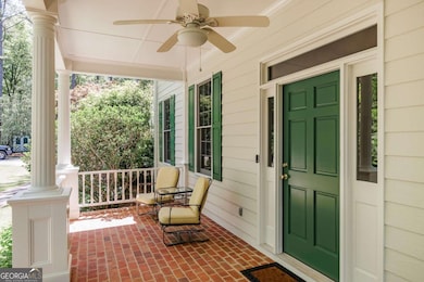
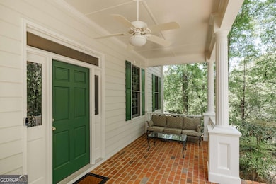
About This Home
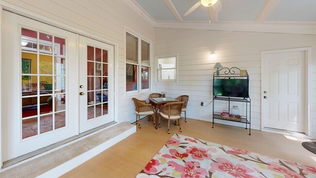
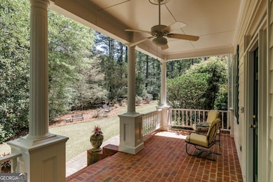
Welcome to this beautifully maintained four-bedroom home, where timeless style meets spacious living in a serene natural setting. With 10-foot ceilings and gleaming hardwood floors throughout the main level, the home feels airy, open, and filled with light. The kitchen is both stylish and functional, featuring custom cabinetry, abundant counter and storage space, a prep sink, and a charming arched brick accent wall that adds warmth and character. Natural light floods the room, creating a welcoming atmosphere ideal for everyday living and entertaining. A spacious breakfast area flows into the formal dining room, perfect for hosting gatherings. The main-level owner's suite is a true retreat, offering a luxuriously updated bath with a frameless glass shower, a classic clawfoot tub, and elegant finishes that blend comfort with sophistication. The inviting family room centers around a wood-burning fireplace and custom built-in bookshelves, offering a comfortable space to relax. From here, step into the cheerful sunroom or unwind on the screened porch, both overlooking a tranquil, wooded backyard-ideal for enjoying the beauty of every season. Also on the main floor, youll find a versatile office that can serve as a library, music room, or creative space. A convenient laundry room and half bath complete the main-level layout. Upstairs, the secondary bedrooms and bathrooms are generously sized, providing flexible options for family, guests, or home office needs. Above the garage, a finished bonus room-accessible from the kitchen and laundry area-offers additional space for a playroom, workout studio, or private office. The unfinished basement provides excellent storage potential. With its thoughtfully designed floor plan, classic charm, and peaceful surroundings, this home seamlessly blends comfort, function, and natural beauty. Come experience what makes it truly special.
Home Details
Home Type
- Single Family
Est. Annual Taxes
- $4,289
Year Built
- Built in 1992
Lot Details
- 2 Acre Lot
- Private Lot
- Level Lot
- Partially Wooded Lot
Home Design
- Traditional Architecture
- Composition Roof
Interior Spaces
- 3,750 Sq Ft Home
- 2-Story Property
- Great Room
- Living Room with Fireplace
- Laundry Room
- Unfinished Basement
Kitchen
- Breakfast Area or Nook
- Dishwasher
- Kitchen Island
Flooring
- Wood
- Carpet
Bedrooms and Bathrooms
- 4 Bedrooms | 1 Primary Bedroom on Main
- Walk-In Closet
- Freestanding Bathtub
- Bathtub Includes Tile Surround
Parking
- 6 Car Garage
- Garage Door Opener
- Off-Street Parking
Outdoor Features
- Patio
Schools
- Timothy Elementary School
- Clarke Middle School
- Clarke Central High School
Utilities
- Central Heating and Cooling System
- Septic Tank
- Cable TV Available
Community Details
- No Home Owners Association
Matterport 3D Tour
Floorplans
Map
Create a Home Valuation Report for This Property
The Home Valuation Report is an in-depth analysis detailing your home's value as well as a comparison with similar homes in the area
Home Values in the Area
Average Home Value in this Area
Tax History
| Year | Tax Paid | Tax Assessment Tax Assessment Total Assessment is a certain percentage of the fair market value that is determined by local assessors to be the total taxable value of land and additions on the property. | Land | Improvement |
|---|---|---|---|---|
| 2025 | $4,249 | $241,514 | $12,320 | $229,194 |
| 2024 | $4,249 | $227,126 | $12,320 | $214,806 |
| 2023 | $4,289 | $208,966 | $12,320 | $196,646 |
| 2022 | $3,959 | $176,910 | $12,320 | $164,590 |
| 2021 | $3,642 | $138,174 | $12,320 | $125,854 |
| 2020 | $3,518 | $129,132 | $12,320 | $116,812 |
| 2019 | $3,510 | $126,457 | $12,320 | $114,137 |
| 2018 | $3,286 | $110,358 | $12,320 | $98,038 |
| 2017 | $0 | $104,291 | $12,320 | $91,971 |
| 2016 | $3,155 | $102,928 | $12,320 | $90,608 |
| 2015 | $3,160 | $102,928 | $12,320 | $90,608 |
| 2014 | $3,165 | $102,928 | $12,320 | $90,608 |
Source: Public Records
Property History
| Date | Event | Price | List to Sale | Price per Sq Ft |
|---|---|---|---|---|
| 11/14/2025 11/14/25 | For Sale | $875,000 | -- | $233 / Sq Ft |
Source: Georgia MLS
Purchase History
| Date | Type | Sale Price | Title Company |
|---|---|---|---|
| Warranty Deed | -- | -- | |
| Deed | -- | -- | |
| Deed | $24,000 | -- | |
| Deed | $15,000 | -- |
Source: Public Records
About the Listing Agent
Clients describe Callie as a good listener, tenacious, fun, dedicated, incredibly knowledgeable, and, of course, professional. These qualities have pushed Callie to the highest level of achievement in the Athens Association of Realtors where she is consistently recognized in the Circle of Honor.
A native of Woodbury, Georgia, Callie attended UGA and decided to make Athens her home after graduating with a BBA in 1992 and an M.Ed. in 1995. Callie and her husband, Paul, are parents of three
Callie's Other Listings
-
$499,000
- 3 Beds
- 2 Baths
- 123 Garden Ln
- Athens, GA
Incredible investment property located close to campus, close to UGA Vet Med Teaching Hospital, close to HWY 316 and downtown Athens too! Updated kitchen and baths are a rare find in our in-town investment properties and 123 Garden Lane is in tip-top shape. This property features three bedrooms, two full baths, hardwood and tile flooring, and a deck for enjoying the backyard. Schedule your
Callie Waller Corcoran Classic Living
Source: Georgia MLS
MLS Number: 10643963
APN: 131-020
Disclaimer: Certain information contained herein is derived from information provided by parties other than Homes.com. All information provided is deemed reliable, but is not guaranteed to be accurate and should be independently verified.
![]() The data relating to real estate for sale on this web site comes in part from the Broker Reciprocity Program of Georgia MLS. Real estate listings held by brokerage firms other than Redfin are marked with the Broker Reciprocity logo and detailed information about them includes the name of the listing brokers. Information deemed reliable but not guaranteed. Copyright 2025 Georgia MLS. All rights reserved.
The data relating to real estate for sale on this web site comes in part from the Broker Reciprocity Program of Georgia MLS. Real estate listings held by brokerage firms other than Redfin are marked with the Broker Reciprocity logo and detailed information about them includes the name of the listing brokers. Information deemed reliable but not guaranteed. Copyright 2025 Georgia MLS. All rights reserved.
Nearby Homes
- 115 Wexford Place Unit ID1302851P
- 116 Colonial Dr
- 342 Timothy Rd
- 1415 Timothy Rd
- 1092 W Lake Dr
- 285 Sycamore Dr Unit 3
- 195 Sycamore Dr
- 240 Sycamore Dr
- 2505 W Broad St Unit 122
- 838 Bobbin Mill Rd Unit ID1302848P
- 840 Bobbin Mill Rd Unit ID1302846P
- 840 Bobbin Mill Rd Unit ID1302841P
- 840 Bobbin Mill Rd Unit ID1302856P
- 840 Bobbin Mill Rd Unit ID1302818P
- 840 Bobbin Mill Rd Unit ID1302820P
- 2110 S Lumpkin St
- 1500 Timothy Rd Unit 20
- 189 Baxter Dr
- 2136 S Lumpkin St
- 625 Epps Bridge Pkwy