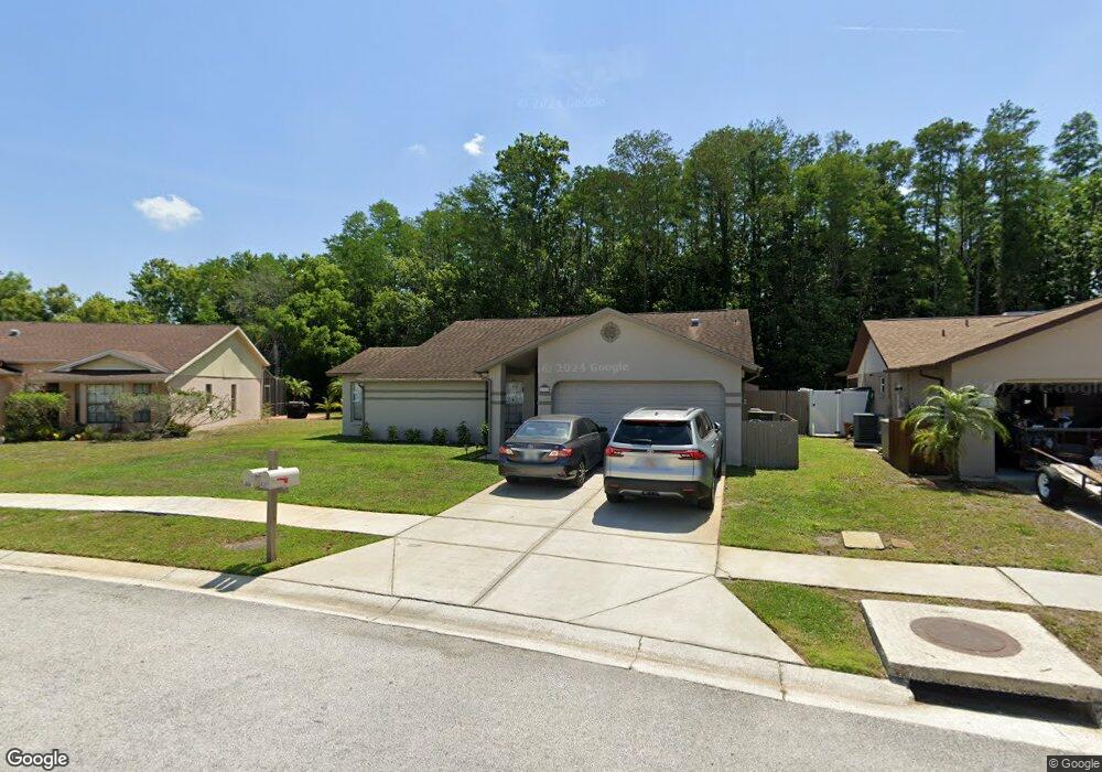
8351 Matthew Dr New Port Richey, FL 34653
Seven Springs NeighborhoodEstimated Value: $280,702 - $364,000
--
Bed
2
Baths
1,596
Sq Ft
$201/Sq Ft
Est. Value
About This Home
This home is located at 8351 Matthew Dr, New Port Richey, FL 34653 and is currently estimated at $320,926, approximately $201 per square foot. 8351 Matthew Dr is a home located in Pasco County with nearby schools including Deer Park Elementary School, River Ridge High School, and River Ridge Middle School.
Ownership History
Date
Name
Owned For
Owner Type
Purchase Details
Closed on
Jan 31, 2000
Sold by
Hillegass Alvin L
Bought by
Owen William and Owen Carol
Current Estimated Value
Home Financials for this Owner
Home Financials are based on the most recent Mortgage that was taken out on this home.
Original Mortgage
$91,247
Outstanding Balance
$29,122
Interest Rate
7.9%
Mortgage Type
FHA
Estimated Equity
$291,804
Purchase Details
Closed on
Jun 19, 1998
Sold by
Smoot Henry A and Smoot Kathleen
Bought by
Hillegass Alvin L
Create a Home Valuation Report for This Property
The Home Valuation Report is an in-depth analysis detailing your home's value as well as a comparison with similar homes in the area
Home Values in the Area
Average Home Value in this Area
Purchase History
| Date | Buyer | Sale Price | Title Company |
|---|---|---|---|
| Owen William | $92,000 | -- | |
| Hillegass Alvin L | $88,500 | -- |
Source: Public Records
Mortgage History
| Date | Status | Borrower | Loan Amount |
|---|---|---|---|
| Open | Hillegass Alvin L | $28,500 | |
| Open | Hillegass Alvin L | $91,247 |
Source: Public Records
Tax History Compared to Growth
Tax History
| Year | Tax Paid | Tax Assessment Tax Assessment Total Assessment is a certain percentage of the fair market value that is determined by local assessors to be the total taxable value of land and additions on the property. | Land | Improvement |
|---|---|---|---|---|
| 2025 | $1,609 | $124,280 | -- | -- |
| 2024 | $1,609 | $120,780 | -- | -- |
| 2023 | $1,541 | $117,270 | $0 | $0 |
| 2022 | $1,377 | $113,860 | $0 | $0 |
| 2021 | $1,341 | $110,550 | $48,418 | $62,132 |
| 2020 | $1,313 | $109,030 | $48,418 | $60,612 |
| 2019 | $1,281 | $106,580 | $0 | $0 |
| 2018 | $1,236 | $104,594 | $0 | $0 |
| 2017 | $1,225 | $104,594 | $0 | $0 |
| 2016 | $1,166 | $100,336 | $0 | $0 |
| 2015 | $1,181 | $99,639 | $0 | $0 |
| 2014 | $1,144 | $98,848 | $32,980 | $65,868 |
Source: Public Records
Map
Nearby Homes
- 5221 Spike Horn Dr
- 8448 Red Roe Dr
- 8346 Shallow Creek Ct
- 8341 Shallow Creek Ct
- 8447 Shallow Creek Ct
- 8237 Setters Point Dr
- 8546 Great Egret Trace
- 8548 Shallow Creek Ct
- 8604 Great Egret Trace
- 8450 Royal Hart Dr
- 8122 Matthew Dr
- 7932 Plathe Rd
- 7902 Royal Hart Dr
- 4728 Swallowtail Dr
- 5515 Gannett Ct
- 7846 Royal Hart Dr
- 5036 Glenhurst Ln
- 5514 Gannett Ct
- 4622 Whitetail Ln
- 5701 Mossberg Dr
- 8357 Matthew Dr
- 8363 Matthew Dr
- 8341 Matthew Dr
- 8338 Matthew Dr
- 8330 Matthew Dr
- 8344 Matthew Dr
- 8369 Matthew Dr
- 8337 Matthew Dr
- 8320 Matthew Dr
- 5161 Spike Horn Dr
- 5153 Spike Horn Dr
- 5207 Spike Horn Dr
- 5145 Spike Horn Dr
- 8356 Matthew Dr
- 5215 Spike Horn Dr
- 8333 Matthew Dr
- 8373 Matthew Dr
- 5139 Spike Horn Dr
- 8314 Matthew Dr
- 5131 Spike Horn Dr