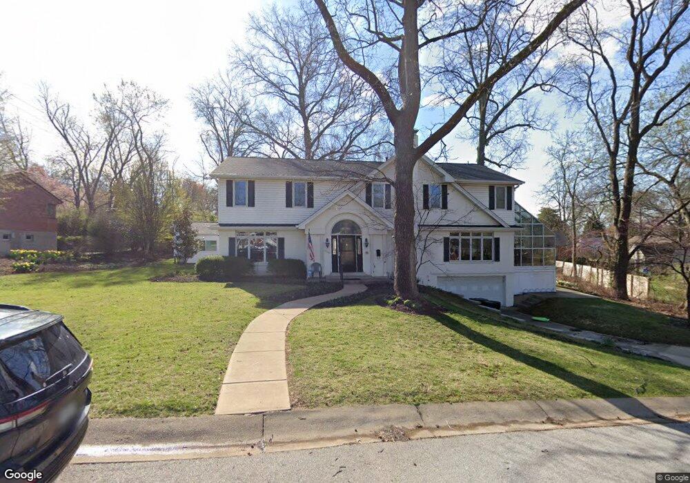
8360 Balson Ave Saint Louis, MO 63132
Estimated Value: $703,000 - $909,000
10
Beds
6
Baths
4,122
Sq Ft
$203/Sq Ft
Est. Value
About This Home
This home is located at 8360 Balson Ave, Saint Louis, MO 63132 and is currently estimated at $837,191, approximately $203 per square foot. 8360 Balson Ave is a home located in St. Louis County with nearby schools including Flynn Park Elementary, Brittany Woods Middle School, and University City High School.
Ownership History
Date
Name
Owned For
Owner Type
Purchase Details
Closed on
Apr 19, 1999
Sold by
Spetner Rita K and Spetner Kenneth
Bought by
Spetner Jonathan S and Spetner Michelle A
Current Estimated Value
Home Financials for this Owner
Home Financials are based on the most recent Mortgage that was taken out on this home.
Original Mortgage
$140,000
Interest Rate
6.92%
Purchase Details
Closed on
Oct 30, 1998
Sold by
Spetner Rita K
Bought by
Spetner Rita K and Spetner Kenneth
Create a Home Valuation Report for This Property
The Home Valuation Report is an in-depth analysis detailing your home's value as well as a comparison with similar homes in the area
Home Values in the Area
Average Home Value in this Area
Purchase History
| Date | Buyer | Sale Price | Title Company |
|---|---|---|---|
| Spetner Jonathan S | -- | -- | |
| Spetner Rita K | -- | -- |
Source: Public Records
Mortgage History
| Date | Status | Borrower | Loan Amount |
|---|---|---|---|
| Previous Owner | Spetner Jonathan S | $140,000 |
Source: Public Records
Tax History
| Year | Tax Paid | Tax Assessment Tax Assessment Total Assessment is a certain percentage of the fair market value that is determined by local assessors to be the total taxable value of land and additions on the property. | Land | Improvement |
|---|---|---|---|---|
| 2025 | $8,391 | $104,540 | $48,430 | $56,110 |
| 2024 | $8,391 | $118,360 | $33,920 | $84,440 |
| 2023 | $8,379 | $118,360 | $33,920 | $84,440 |
| 2022 | $8,318 | $109,570 | $29,070 | $80,500 |
| 2021 | $8,233 | $109,570 | $29,070 | $80,500 |
| 2020 | $5,904 | $76,420 | $27,380 | $49,040 |
| 2019 | $5,852 | $76,420 | $27,380 | $49,040 |
| 2018 | $5,293 | $63,860 | $17,750 | $46,110 |
| 2017 | $5,304 | $63,860 | $17,750 | $46,110 |
| 2016 | $4,654 | $53,570 | $8,650 | $44,920 |
Source: Public Records
Map
Nearby Homes
- 852 Berick Dr
- 8122 Gannon Ave
- 4 Delcrest Ct Unit 104
- 3 Delcrest Ct Unit 102
- 7918 Cornell Ave
- 8333 Kingsbury Blvd
- 7900 Cornell Ave
- 8233 Swarthmore Ct
- 9112 Watsonia Ct
- 7843 Cornell Ave
- 8637 Mayflower Ct
- 212 Gay Ave
- 7823 Stanford Ave
- 39 Willow Hill Rd
- 8161 Stratford Dr
- 961 Briarwood Ln
- 51 Kings Lynn
- 4 Pricemont Dr
- 962 Warder Ave
- 972 Warder Ave
- 8331 Stanford Ave
- 8350 Balson Ave
- 808 Oakbrook Ln
- 8337 Stanford Ave
- 8325 Stanford Ave
- 8361 Balson Ave
- 816 Oakbrook Ln
- 800 Oakbrook Ln
- 8340 Balson Ave
- 843 University Place
- 851 Alanson Dr
- 822 Oakbrook Ln
- 8324 Stanford Ave
- 849 University Place
- 835 University Place
- 8336 Stanford Ave
- 8330 Stanford Ave
- 861 Alanson Dr
- 855 University Place
- 760 Oakbrook Ln
Your Personal Tour Guide
Ask me questions while you tour the home.