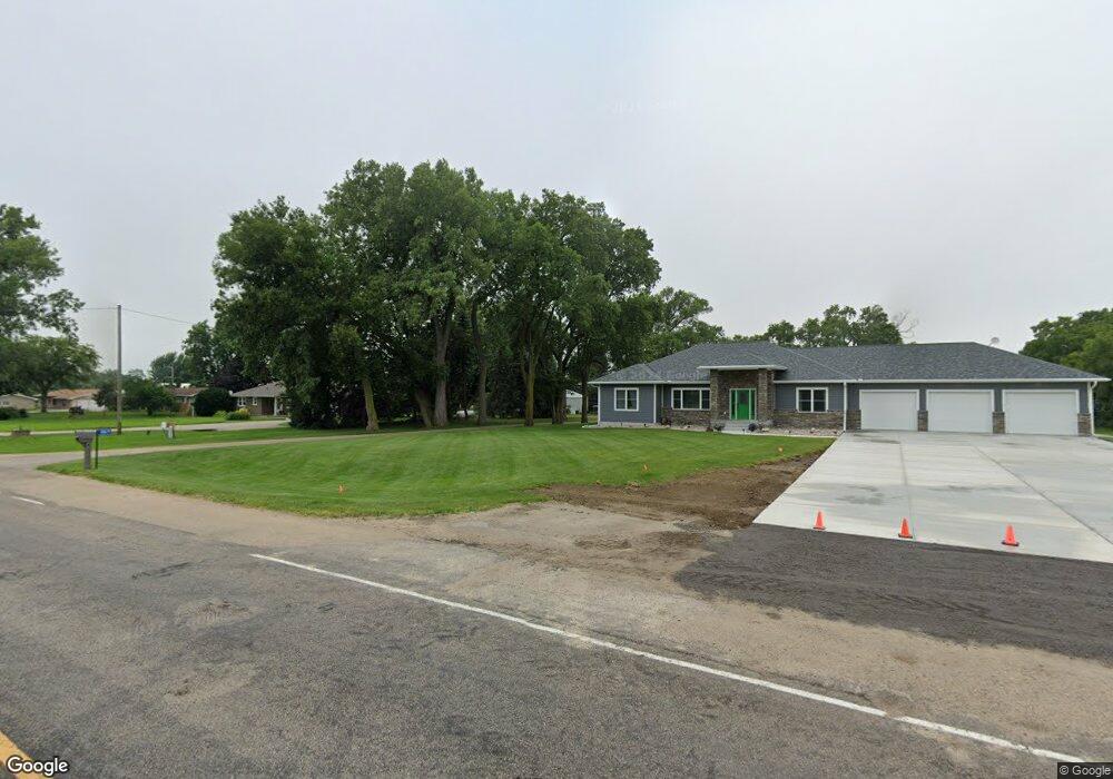
83675 555th Ave Norfolk, NE 68701
Estimated Value: $255,000 - $415,000
3
Beds
2
Baths
1,572
Sq Ft
$220/Sq Ft
Est. Value
About This Home
This home is located at 83675 555th Ave, Norfolk, NE 68701 and is currently estimated at $346,211, approximately $220 per square foot. 83675 555th Ave is a home located in Madison County with nearby schools including Battle Creek Elementary School and Battle Creek High School.
Ownership History
Date
Name
Owned For
Owner Type
Purchase Details
Closed on
Jul 18, 2025
Sold by
Abler Farms Llc
Bought by
Sock Kurt and Sock Robin
Current Estimated Value
Purchase Details
Closed on
May 11, 2022
Sold by
Hoff Sr Daniel J and Hoff Lori D
Bought by
Sock Kurt and Sock Robin
Home Financials for this Owner
Home Financials are based on the most recent Mortgage that was taken out on this home.
Original Mortgage
$230,000
Interest Rate
5.27%
Mortgage Type
New Conventional
Purchase Details
Closed on
Mar 30, 2021
Sold by
Hoff Dallas and Hoff Dallas B
Bought by
Stuchlik Shannon and Stuchlik Kelly
Purchase Details
Closed on
Mar 15, 2004
Sold by
Hohenstein Et Al, Bernice E
Bought by
Hoff Sr Daniel J and Hoff Sr Lori D
Purchase Details
Closed on
May 5, 2003
Sold by
Hohenstein Estate Walter O
Bought by
Preusker Et Al, Karen J
Create a Home Valuation Report for This Property
The Home Valuation Report is an in-depth analysis detailing your home's value as well as a comparison with similar homes in the area
Home Values in the Area
Average Home Value in this Area
Purchase History
| Date | Buyer | Sale Price | Title Company |
|---|---|---|---|
| Sock Kurt | $5,000 | None Listed On Document | |
| Sock Kurt | $5,000 | None Listed On Document | |
| Sock Kurt | $310,000 | Stewart Title | |
| Stuchlik Shannon | $285,000 | Chilvers Abstract & Ttl Co I | |
| Hoff Sr Daniel J | $130,000 | -- | |
| Preusker Et Al, Karen J | -- | -- |
Source: Public Records
Mortgage History
| Date | Status | Borrower | Loan Amount |
|---|---|---|---|
| Previous Owner | Sock Kurt | $230,000 |
Source: Public Records
Tax History Compared to Growth
Tax History
| Year | Tax Paid | Tax Assessment Tax Assessment Total Assessment is a certain percentage of the fair market value that is determined by local assessors to be the total taxable value of land and additions on the property. | Land | Improvement |
|---|---|---|---|---|
| 2024 | $2,773 | $327,476 | $40,000 | $287,476 |
| 2023 | $4,064 | $301,980 | $35,000 | $266,980 |
| 2022 | $3,780 | $280,826 | $35,000 | $245,826 |
| 2021 | $3,277 | $251,419 | $25,000 | $226,419 |
| 2020 | $3,251 | $251,419 | $25,000 | $226,419 |
| 2019 | $3,015 | $235,446 | $25,000 | $210,446 |
| 2018 | $2,692 | $224,144 | $25,000 | $199,144 |
| 2017 | $2,543 | $208,591 | $25,000 | $183,591 |
| 2016 | $2,427 | $189,322 | $20,000 | $169,322 |
| 2015 | $2,403 | $189,322 | $20,000 | $169,322 |
| 2014 | $2,349 | $171,231 | $15,000 | $156,231 |
| 2013 | $2,742 | $171,231 | $15,000 | $156,231 |
Source: Public Records
Map
Nearby Homes
- 837 Rd
- 837th Rd
- 100 Helen Ave
- 101 Henry Ave
- 100 Henry Ave
- 101 Adealia Ave
- 101 Frank Ave
- 808 Andy's Shore N
- 2208 S 1st St
- 5105 W Sherwood Rd
- 1201 S Victory Rd
- 1101 S Victory Rd
- 1100 S Victory Rd
- 1406 S 2nd St
- 1405 S 2nd St
- 1303 S 3rd St
- 1104 S 2nd St
- 3307 W Michigan Ave
- 3206 W Michigan Ave
- 3205 W Michigan Ave
- 83671 555th Ave
- 83679 555th Ave
- 83667 555th Ave
- 83683 555th Ave
- 83672 555th Ave
- 83666 555th Ave
- 83674 555th Ave
- 83663 555th Ave
- 83687 555th Ave
- 83662 555th Ave
- 83659 555th Ave
- 83682 555th Ave
- 83655 555th Ave
- 83684 555th Ave
- PT SW1/4 NW1/4 22-23-1 3 04 Acres
- PT SW 1/4 NW 1 4 22-23-1 3 04 Acres
- PT SW 1/4 NW 1 4 2202301 3 04 Acres
- 83668 555th Ave
- 83689 555th Ave
- 83689 555 Ave