Estimated Value: $135,000 - $217,000
3
Beds
1
Bath
1,152
Sq Ft
$153/Sq Ft
Est. Value
About This Home
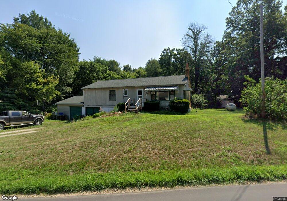
This home is located at 837 Leet Rd, Niles, MI 49120 and is currently estimated at $176,549, approximately $153 per square foot. 837 Leet Rd is a home located in Cass County with nearby schools including Edwardsburg Primary School, Eagle Lake Elementary School, and Edwardsburg Intermediate School.
Ownership History
Date
Name
Owned For
Owner Type
Purchase Details
Closed on
Jan 19, 2006
Sold by
Deutsche Bank Trust Co Americas
Bought by
Bolle Stanley J and Bolle Rita G
Current Estimated Value
Purchase Details
Closed on
May 4, 2005
Sold by
Haines Todd and Haines Sally
Bought by
Deutsche Bank Trust Co Americas and Bankers Trust Co
Create a Home Valuation Report for This Property
The Home Valuation Report is an in-depth analysis detailing your home's value as well as a comparison with similar homes in the area
Home Values in the Area
Average Home Value in this Area
Purchase History
| Date | Buyer | Sale Price | Title Company |
|---|---|---|---|
| Bolle Stanley J | $42,750 | None Available | |
| Deutsche Bank Trust Co Americas | $54,400 | -- |
Source: Public Records
Tax History Compared to Growth
Tax History
| Year | Tax Paid | Tax Assessment Tax Assessment Total Assessment is a certain percentage of the fair market value that is determined by local assessors to be the total taxable value of land and additions on the property. | Land | Improvement |
|---|---|---|---|---|
| 2025 | $1,895 | $58,400 | $58,400 | $0 |
| 2024 | $467 | $57,900 | $57,900 | $0 |
| 2023 | $446 | $47,600 | $0 | $0 |
| 2022 | $424 | $52,800 | $0 | $0 |
| 2021 | $1,634 | $57,200 | $0 | $0 |
| 2020 | $1,618 | $53,600 | $0 | $0 |
| 2019 | $1,549 | $52,200 | $0 | $0 |
| 2018 | $391 | $46,600 | $0 | $0 |
| 2017 | $383 | $43,700 | $0 | $0 |
| 2016 | $379 | $39,580 | $0 | $0 |
| 2015 | -- | $40,000 | $0 | $0 |
| 2011 | -- | $37,100 | $0 | $0 |
Source: Public Records
Map
Nearby Homes
- 1002 Leet Rd
- 2760 Detroit Rd
- 2561 Lake Shore Dr
- 2671 Mulberry St
- 2419 Blanchard Dr
- 69260 Anderson Rd
- 30417 U S 12
- 2726 Horton Ct
- 2511 Heath Dr
- 69594 Anderson Rd
- 2354 Yankee St
- 69535 Turkey Trail Dr
- 1403 Barron Lake Rd
- 892 Sullivan Rd
- 2298 Yankee St
- 66741 Conrad Rd
- 66017 Conrad Rd
- 33546 Frantz Dr
- 29750 Edwards Way
- 33273 U S 12