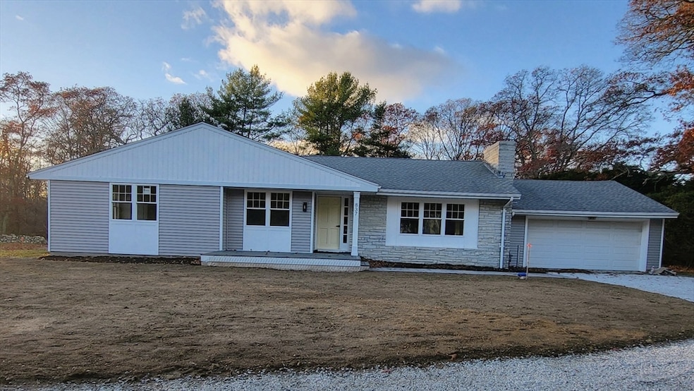


837 Main Rd Westport, MA 02790
Booth/Handy Four Corners NeighborhoodEstimated payment $4,122/month
Highlights
- Marina
- Community Stables
- 4.72 Acre Lot
- Golf Course Community
- Medical Services
- Deck
About This Home
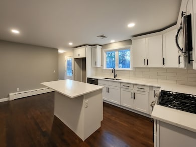
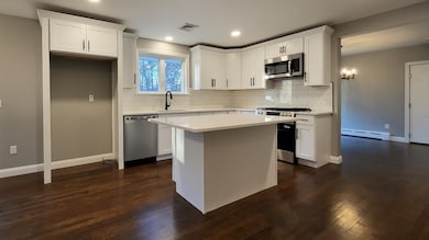
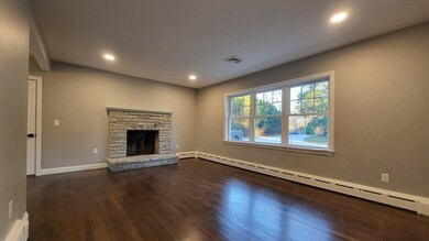
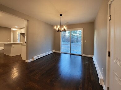
Welcome to Westport Central Village! Come see this wonderful 3 bedroom, 1.5 bathroom home in a great location!. Just finished being renovated and ready to move in! New windows, vinyl siding, decks, A/C, doors, septic system, well pump, flooring and many more upgrades. Ideal location...Short walk to a pharmacy, 2 banks, doctors office, town hall, coffee shop, grocery store, restaurants, etc. This beautiful new kitchen has slow close doors/drawers, stainless steel appliances and quartz countertops! Double vanity with quartz top. The large finished basement has a half bathroom, separately zoned baseboard heat, laundry area, storage room, workshop, and access to the finished garage. Home is larger than appears.Option to purchase as package deal with buidlable lot, plans, etc. (9 acres total) for 949k. Lot not for sale separately.
Home Details
Home Type
- Single Family
Est. Annual Taxes
- $3,843
Year Built
- Built in 1963
Lot Details
- 4.72 Acre Lot
- Cleared Lot
- Wooded Lot
Parking
- 2 Car Attached Garage
- Parking Storage or Cabinetry
- Side Facing Garage
- Garage Door Opener
- Shared Driveway
- Open Parking
- Off-Street Parking
Home Design
- Ranch Style House
- Blown Fiberglass Insulation
- Batts Insulation
- Shingle Roof
- Concrete Perimeter Foundation
Interior Spaces
- Sheet Rock Walls or Ceilings
- 1 Fireplace
- Insulated Windows
- Window Screens
- Insulated Doors
- Attic Ventilator
- Washer and Electric Dryer Hookup
Kitchen
- Range
- Microwave
- Dishwasher
Flooring
- Wood
- Laminate
- Tile
Bedrooms and Bathrooms
- 3 Bedrooms
Finished Basement
- Walk-Out Basement
- Basement Fills Entire Space Under The House
- Interior Basement Entry
- Block Basement Construction
Outdoor Features
- Deck
- Rain Gutters
Location
- Property is near public transit
- Property is near schools
Utilities
- Central Air
- 1 Cooling Zone
- 2 Heating Zones
- Heating System Uses Natural Gas
- Baseboard Heating
- 200+ Amp Service
- Private Water Source
- Gas Water Heater
- Private Sewer
Listing and Financial Details
- Tax Lot 22
- Assessor Parcel Number 3001351
Community Details
Overview
- No Home Owners Association
- Near Conservation Area
Amenities
- Medical Services
- Shops
Recreation
- Marina
- Golf Course Community
- Tennis Courts
- Community Stables
- Jogging Path
- Bike Trail
Map
Home Values in the Area
Average Home Value in this Area
Tax History
| Year | Tax Paid | Tax Assessment Tax Assessment Total Assessment is a certain percentage of the fair market value that is determined by local assessors to be the total taxable value of land and additions on the property. | Land | Improvement |
|---|---|---|---|---|
| 2025 | $3,843 | $515,900 | $266,200 | $249,700 |
| 2024 | $3,775 | $488,400 | $242,000 | $246,400 |
| 2023 | $3,559 | $436,100 | $213,100 | $223,000 |
| 2022 | $3,372 | $397,600 | $213,100 | $184,500 |
| 2021 | $3,193 | $370,400 | $190,600 | $179,800 |
| 2020 | $3,000 | $355,900 | $176,100 | $179,800 |
| 2019 | $2,962 | $358,200 | $176,100 | $182,100 |
| 2018 | $2,967 | $363,200 | $196,500 | $166,700 |
| 2017 | $2,840 | $356,300 | $192,800 | $163,500 |
| 2016 | $2,670 | $337,600 | $189,000 | $148,600 |
| 2015 | $2,573 | $324,500 | $191,500 | $133,000 |
Property History
| Date | Event | Price | List to Sale | Price per Sq Ft |
|---|---|---|---|---|
| 11/18/2025 11/18/25 | Pending | -- | -- | -- |
| 11/17/2025 11/17/25 | For Sale | $719,900 | -- | $460 / Sq Ft |
Purchase History
| Date | Type | Sale Price | Title Company |
|---|---|---|---|
| Quit Claim Deed | $500,000 | None Available | |
| Quit Claim Deed | $500,000 | None Available | |
| Quit Claim Deed | $500,000 | None Available | |
| Quit Claim Deed | -- | None Available | |
| Quit Claim Deed | -- | None Available | |
| Quit Claim Deed | -- | None Available |
Mortgage History
| Date | Status | Loan Amount | Loan Type |
|---|---|---|---|
| Open | $850,000 | Purchase Money Mortgage | |
| Closed | $850,000 | Purchase Money Mortgage |
Source: MLS Property Information Network (MLS PIN)
MLS Number: 73455743
APN: WPOR-000077-000000-000020-000022
Disclaimer: Certain information contained herein is derived from information provided by parties other than Homes.com. All information provided is deemed reliable, but is not guaranteed to be accurate and should be independently verified.
![]() The property listing data and information, or the Images, set forth herein were provided to MLS Property Information Network, Inc. from third party sources, including sellers, lessors and public records, and were compiled by MLS Property Information Network, Inc. The property listing data and information, and the Images, are for the personal, non-commercial use of consumers having a good faith interest in purchasing or leasing listed properties of the type displayed to them and may not be used for any purpose other than to identify prospective properties which such consumers may have a good faith interest in purchasing or leasing. MLS Property Information Network, Inc. and its subscribers disclaim any and all representations and warranties as to the accuracy of the property listing data and information, or as to the accuracy of any of the Images, set forth herein.
The property listing data and information, or the Images, set forth herein were provided to MLS Property Information Network, Inc. from third party sources, including sellers, lessors and public records, and were compiled by MLS Property Information Network, Inc. The property listing data and information, and the Images, are for the personal, non-commercial use of consumers having a good faith interest in purchasing or leasing listed properties of the type displayed to them and may not be used for any purpose other than to identify prospective properties which such consumers may have a good faith interest in purchasing or leasing. MLS Property Information Network, Inc. and its subscribers disclaim any and all representations and warranties as to the accuracy of the property listing data and information, or as to the accuracy of any of the Images, set forth herein.
- 8 Village Way
- 7 Village Way
- 15 Village Way
- 101 Adamsville Rd
- 920 Drift Rd
- 225 Hixbridge Rd
- 8 Strawberry Ln
- 118 Charlotte White Rd Extension
- 0 Hidden Glen Ln
- 978 Sodom Rd
- 1346 Main Rd Unit B
- 118 Charlotte White Rd
- Lot 0 Marcotte
- 17 Quail Trail
- 47 Fallon Dr
- 73 White Oak Run
- 9 Division Rd
- 1580 Main Rd
- 99 Sylvia Ln
- 7 Taber Ln
