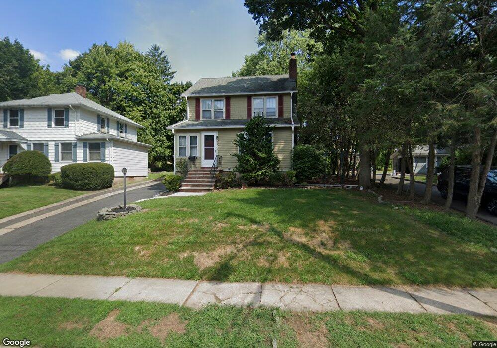
838 Bogert Rd River Edge, NJ 07661
Estimated Value: $727,000 - $812,000
3
Beds
2
Baths
1,887
Sq Ft
$408/Sq Ft
Est. Value
About This Home
This home is located at 838 Bogert Rd, River Edge, NJ 07661 and is currently estimated at $769,518, approximately $407 per square foot. 838 Bogert Rd is a home located in Bergen County with nearby schools including Roosevelt Elementary School, River Dell Middle School, and River Dell Regional High School.
Ownership History
Date
Name
Owned For
Owner Type
Purchase Details
Closed on
Jul 7, 2021
Sold by
Abernathy Michael and Rossy Abernathy Mia
Bought by
Ndoja Salmi and Ndoja Azalina
Current Estimated Value
Purchase Details
Closed on
Aug 30, 2012
Sold by
Simpson Ruth E
Bought by
Abernathy Michael and Rossy-Abernathy Mia K
Home Financials for this Owner
Home Financials are based on the most recent Mortgage that was taken out on this home.
Original Mortgage
$328,143
Interest Rate
3.57%
Mortgage Type
FHA
Create a Home Valuation Report for This Property
The Home Valuation Report is an in-depth analysis detailing your home's value as well as a comparison with similar homes in the area
Home Values in the Area
Average Home Value in this Area
Purchase History
| Date | Buyer | Sale Price | Title Company |
|---|---|---|---|
| Ndoja Salmi | $520,000 | Sunnyside Title Agency | |
| Abernathy Michael | $342,500 | -- |
Source: Public Records
Mortgage History
| Date | Status | Borrower | Loan Amount |
|---|---|---|---|
| Previous Owner | Abernathy Michael | $328,143 |
Source: Public Records
Tax History Compared to Growth
Tax History
| Year | Tax Paid | Tax Assessment Tax Assessment Total Assessment is a certain percentage of the fair market value that is determined by local assessors to be the total taxable value of land and additions on the property. | Land | Improvement |
|---|---|---|---|---|
| 2025 | $14,052 | $662,500 | $326,900 | $335,600 |
| 2024 | $13,701 | $354,400 | $168,000 | $186,400 |
| 2023 | $13,113 | $354,400 | $168,000 | $186,400 |
| 2022 | $13,113 | $354,400 | $168,000 | $186,400 |
| 2021 | $12,854 | $354,400 | $168,000 | $186,400 |
| 2020 | $12,652 | $354,400 | $168,000 | $186,400 |
| 2019 | $12,291 | $354,400 | $168,000 | $186,400 |
| 2018 | $12,032 | $354,400 | $168,000 | $186,400 |
| 2017 | $11,915 | $354,400 | $168,000 | $186,400 |
| 2016 | $11,646 | $354,400 | $168,000 | $186,400 |
| 2015 | $11,401 | $354,400 | $168,000 | $186,400 |
| 2014 | $11,422 | $354,400 | $168,000 | $186,400 |
Source: Public Records
Map
Nearby Homes
- 855 Kinderkamack Rd
- 33 Lincoln Ave
- 784 Millbrook Rd
- 140 River Edge Ave
- 761 6th Ave
- 668 River Rd
- 712 6th Ave
- 766 7th Ave
- 374 E Midland Ave
- 227 Cedar Rd
- 211 Madison Ave
- 276 Greenway Terrace
- 331 Ellen Place
- 327 E Midland Ave
- 729 Schaefer Ave
- 168 Voorhis Ave
- 390 Spring Valley Rd
- 321 Henley Ave
- 366 Spring Valley Rd
- 171 Cleveland St