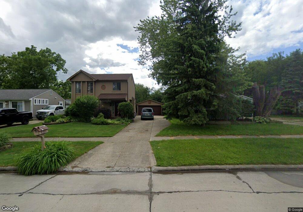
8385 Hugh St Westland, MI 48185
Estimated Value: $251,000 - $310,000
--
Bed
1
Bath
1,261
Sq Ft
$220/Sq Ft
Est. Value
About This Home
This home is located at 8385 Hugh St, Westland, MI 48185 and is currently estimated at $276,919, approximately $219 per square foot. 8385 Hugh St is a home located in Wayne County with nearby schools including Cleveland Elementary School, Cooper Upper Elementary School, and Emerson Middle School.
Ownership History
Date
Name
Owned For
Owner Type
Purchase Details
Closed on
Feb 10, 2004
Sold by
The Bank Of New York
Bought by
Boehms Richard W
Current Estimated Value
Home Financials for this Owner
Home Financials are based on the most recent Mortgage that was taken out on this home.
Original Mortgage
$122,000
Interest Rate
5.5%
Mortgage Type
Purchase Money Mortgage
Purchase Details
Closed on
Jun 11, 2003
Sold by
Iannicello Mike and Hobi Stephen M
Bought by
Nationscredit Home Equity Services Corp
Create a Home Valuation Report for This Property
The Home Valuation Report is an in-depth analysis detailing your home's value as well as a comparison with similar homes in the area
Home Values in the Area
Average Home Value in this Area
Purchase History
| Date | Buyer | Sale Price | Title Company |
|---|---|---|---|
| Boehms Richard W | $155,000 | Attorneys Title Agency Llc | |
| The Bank Of New York | -- | Attorneys Title Agency Llc | |
| Nationscredit Home Equity Services Corp | $155,875 | -- |
Source: Public Records
Mortgage History
| Date | Status | Borrower | Loan Amount |
|---|---|---|---|
| Previous Owner | Boehms Richard W | $122,000 | |
| Closed | Boehms Richard W | $22,875 |
Source: Public Records
Tax History Compared to Growth
Tax History
| Year | Tax Paid | Tax Assessment Tax Assessment Total Assessment is a certain percentage of the fair market value that is determined by local assessors to be the total taxable value of land and additions on the property. | Land | Improvement |
|---|---|---|---|---|
| 2025 | $2,698 | $139,900 | $0 | $0 |
| 2024 | $2,698 | $128,800 | $0 | $0 |
| 2023 | $2,577 | $122,600 | $0 | $0 |
| 2022 | $2,922 | $111,800 | $0 | $0 |
| 2021 | $2,848 | $102,000 | $0 | $0 |
| 2020 | $2,816 | $97,500 | $0 | $0 |
| 2019 | $2,673 | $88,400 | $0 | $0 |
| 2018 | $2,175 | $76,100 | $0 | $0 |
| 2017 | $830 | $75,100 | $0 | $0 |
| 2016 | $2,547 | $76,000 | $0 | $0 |
| 2015 | $5,163 | $55,100 | $0 | $0 |
| 2013 | $5,351 | $57,550 | $0 | $0 |
| 2012 | $2,330 | $55,860 | $0 | $0 |
Source: Public Records
Map
Nearby Homes
- 8411 Hugh St
- 8483 Beatrice
- 8618 Beatrice
- 8309 Hugh St
- 8037 Beatrice
- 8177 Gary Ave
- 8157 Gary Ave
- 8148 Randy Dr
- 8938 Hugh St
- 0000 N Middlebelt Rd
- 29156 Manchester St
- 29248 Manchester St
- 8139 Bristol St Unit 170
- 28926 Ann Arbor Trail
- 29047 Manchester St Unit 83
- 29000 Joy Rd
- 8346 Hillcrest Blvd
- 7841 Randy Dr
- 9081 Louise St
- 29639 Shacket St