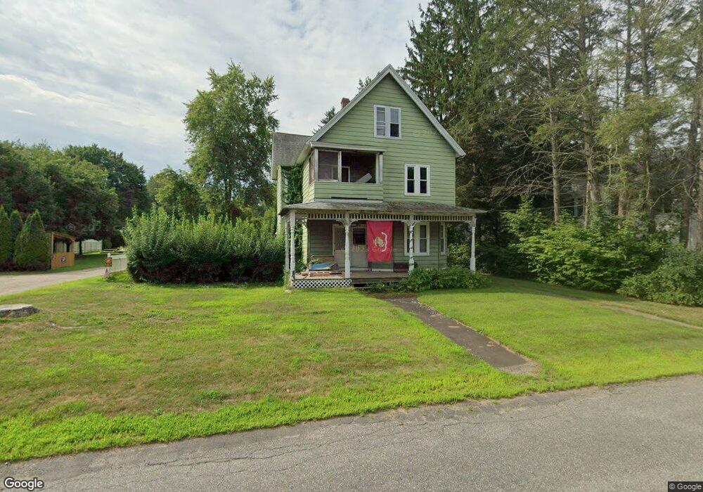
84 Depot St Broad Brook, CT 06016
Estimated Value: $285,000 - $382,000
4
Beds
2
Baths
1,972
Sq Ft
$165/Sq Ft
Est. Value
About This Home
This home is located at 84 Depot St, Broad Brook, CT 06016 and is currently estimated at $325,802, approximately $165 per square foot. 84 Depot St is a home located in Hartford County with nearby schools including Broad Brook Elementary School, East Windsor Middle School, and East Windsor High School.
Ownership History
Date
Name
Owned For
Owner Type
Purchase Details
Closed on
Nov 15, 2007
Sold by
Est Fahey Marian and Fahey Tracey
Bought by
Gahr Gail and Gahr Christopher
Current Estimated Value
Home Financials for this Owner
Home Financials are based on the most recent Mortgage that was taken out on this home.
Original Mortgage
$125,000
Interest Rate
6.41%
Create a Home Valuation Report for This Property
The Home Valuation Report is an in-depth analysis detailing your home's value as well as a comparison with similar homes in the area
Home Values in the Area
Average Home Value in this Area
Purchase History
| Date | Buyer | Sale Price | Title Company |
|---|---|---|---|
| Gahr Gail | $145,000 | -- |
Source: Public Records
Mortgage History
| Date | Status | Borrower | Loan Amount |
|---|---|---|---|
| Open | Gahr Gail | $127,500 | |
| Closed | Gahr Gail | $25,000 | |
| Closed | Gahr Gail | $125,000 |
Source: Public Records
Tax History Compared to Growth
Tax History
| Year | Tax Paid | Tax Assessment Tax Assessment Total Assessment is a certain percentage of the fair market value that is determined by local assessors to be the total taxable value of land and additions on the property. | Land | Improvement |
|---|---|---|---|---|
| 2025 | $4,416 | $166,720 | $54,590 | $112,130 |
| 2024 | $4,095 | $166,720 | $54,590 | $112,130 |
| 2023 | $3,179 | $92,730 | $49,020 | $43,710 |
| 2022 | $3,400 | $92,730 | $49,020 | $43,710 |
| 2021 | $3,199 | $92,730 | $49,020 | $43,710 |
| 2020 | $3,220 | $92,730 | $49,020 | $43,710 |
| 2019 | $3,176 | $92,730 | $49,020 | $43,710 |
| 2018 | $3,144 | $92,730 | $49,020 | $43,710 |
| 2017 | $3,586 | $109,440 | $54,830 | $54,610 |
| 2016 | $3,324 | $107,480 | $54,830 | $52,650 |
| 2015 | $3,258 | $107,480 | $54,830 | $52,650 |
| 2014 | $3,201 | $107,480 | $54,830 | $52,650 |
Source: Public Records
Map
Nearby Homes
- 11 Acorn Dr Unit 11
- 56 Highland Ave
- 4 Rye St
- 111 Old Ellington Rd
- 18 Wesley Rd
- 35 Church St
- 16 Joseph Ct Unit 16
- 3 Eastwood Dr
- 30 Julia Ct Unit 30
- 26 Julia Ct Unit 26
- 27 Old Ellington Rd
- 14 Bridle Path
- 183 Chamberlain Rd
- 27 Folkstone Rd Unit C
- 77 Thrall Rd
- 62 Rice Rd
- 7 East Rd
- 20 Apothecaries Hall Rd
- 0 Wells Rd
- 0 Chamberlain Rd Unit 24129492
- 82 Depot St
- 86 Depot St
- 80 Depot St
- 83 Depot St
- 81 Depot St
- 90 Depot St
- 2 Hillside Farms Dr
- 2 Hillside Farms Dr Unit 2
- 53 Depot St
- 79 Depot St
- 78 Depot St
- 87 Depot St
- 77 Depot St
- 50 Hillside Farms Dr
- 76 Depot St
- 52 Hillside Farms Dr
- 52 Hillside Farms Dr Unit 52
- 48 Hillside Farms Dr
- 48 Hillside Farms Dr Unit 48
- 46 Hillside Farms Dr