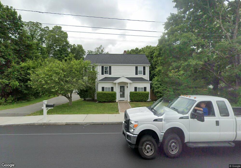
84 Main St Walpole, MA 02081
Estimated Value: $592,000 - $611,000
3
Beds
1
Bath
1,632
Sq Ft
$369/Sq Ft
Est. Value
About This Home
This home is located at 84 Main St, Walpole, MA 02081 and is currently estimated at $602,490, approximately $369 per square foot. 84 Main St is a home located in Norfolk County with nearby schools including Fisher School, Walpole Middle School, and Walpole High School.
Ownership History
Date
Name
Owned For
Owner Type
Purchase Details
Closed on
Jul 15, 2020
Sold by
Randall Richard and Randall Marianne
Bought by
R & M Randall Ft
Current Estimated Value
Purchase Details
Closed on
May 26, 1993
Sold by
Bailey Priscilla A
Bought by
Randall Richard
Home Financials for this Owner
Home Financials are based on the most recent Mortgage that was taken out on this home.
Original Mortgage
$106,500
Interest Rate
7.41%
Mortgage Type
Purchase Money Mortgage
Create a Home Valuation Report for This Property
The Home Valuation Report is an in-depth analysis detailing your home's value as well as a comparison with similar homes in the area
Home Values in the Area
Average Home Value in this Area
Purchase History
| Date | Buyer | Sale Price | Title Company |
|---|---|---|---|
| R & M Randall Ft | -- | None Available | |
| Randall Richard | $113,000 | -- |
Source: Public Records
Mortgage History
| Date | Status | Borrower | Loan Amount |
|---|---|---|---|
| Previous Owner | Randall Richard | $169,000 | |
| Previous Owner | Randall Richard | $40,000 | |
| Previous Owner | Randall Richard | $106,500 | |
| Previous Owner | Randall Richard | $20,691 |
Source: Public Records
Tax History
| Year | Tax Paid | Tax Assessment Tax Assessment Total Assessment is a certain percentage of the fair market value that is determined by local assessors to be the total taxable value of land and additions on the property. | Land | Improvement |
|---|---|---|---|---|
| 2025 | $6,891 | $537,100 | $281,200 | $255,900 |
| 2024 | $6,681 | $505,400 | $270,300 | $235,100 |
| 2023 | $6,481 | $466,600 | $235,100 | $231,500 |
| 2022 | $6,096 | $421,600 | $217,700 | $203,900 |
| 2021 | $5,794 | $390,400 | $205,400 | $185,000 |
| 2020 | $5,620 | $374,900 | $183,600 | $191,300 |
| 2019 | $5,338 | $353,500 | $176,500 | $177,000 |
| 2018 | $4,891 | $320,300 | $160,700 | $159,600 |
| 2017 | $4,722 | $308,000 | $154,600 | $153,400 |
| 2016 | $4,582 | $294,500 | $157,900 | $136,600 |
| 2015 | $4,184 | $266,500 | $133,700 | $132,800 |
| 2014 | $4,003 | $254,000 | $133,700 | $120,300 |
Source: Public Records
Map
Nearby Homes
- 40 Endean Dr
- 241 Fisher St
- 8 Mckinley Ave
- 65 Alandale Pkwy
- 5 Endicott St Unit 3
- 74 Alandale Pkwy
- 291 Plimpton St
- 70 Endicott St Unit 401
- 363 - 367 Washington St
- 53 Tremont St
- 0 Charlotte Rd
- 26 Albemarle Rd
- 7 Atwood Ave
- 5 Atwood Ave
- 486 Washington St
- 26 Saint Josephs Ave
- 1086 Washington St
- 272 Union St Unit 272
- Unit 11 Powder House Ln Unit 11
- 8 Powder House Ln Unit 2
Your Personal Tour Guide
Ask me questions while you tour the home.