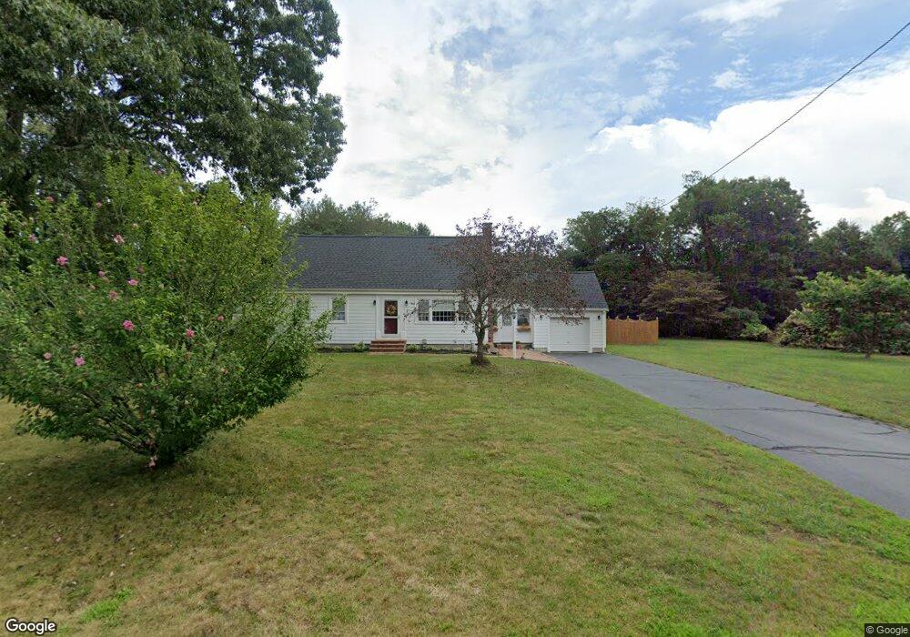
84 Phillips Ln Wrentham, MA 02093
Estimated Value: $425,000 - $614,000
3
Beds
1
Bath
1,368
Sq Ft
$403/Sq Ft
Est. Value
About This Home
This home is located at 84 Phillips Ln, Wrentham, MA 02093 and is currently estimated at $551,553, approximately $403 per square foot. 84 Phillips Ln is a home located in Norfolk County with nearby schools including Delaney Elementary School and Charles E Roderick.
Ownership History
Date
Name
Owned For
Owner Type
Purchase Details
Closed on
Dec 11, 2015
Sold by
Donovan Sylvia J
Bought by
Donovan Sylvia J and Duvarney Robin R
Current Estimated Value
Purchase Details
Closed on
Nov 27, 1978
Bought by
Donovan Sylvia J and Duvarney Robin R
Create a Home Valuation Report for This Property
The Home Valuation Report is an in-depth analysis detailing your home's value as well as a comparison with similar homes in the area
Purchase History
| Date | Buyer | Sale Price | Title Company |
|---|---|---|---|
| Donovan Sylvia J | -- | -- | |
| Donovan Sylvia J | -- | -- |
Source: Public Records
Mortgage History
| Date | Status | Borrower | Loan Amount |
|---|---|---|---|
| Previous Owner | Donovan Sylvia J | $42,500 |
Source: Public Records
Tax History
| Year | Tax Paid | Tax Assessment Tax Assessment Total Assessment is a certain percentage of the fair market value that is determined by local assessors to be the total taxable value of land and additions on the property. | Land | Improvement |
|---|---|---|---|---|
| 2025 | $6,190 | $534,100 | $291,500 | $242,600 |
| 2024 | $5,986 | $498,800 | $291,500 | $207,300 |
| 2023 | $5,723 | $453,500 | $265,000 | $188,500 |
| 2022 | $5,752 | $420,800 | $247,300 | $173,500 |
| 2021 | $5,359 | $380,900 | $215,800 | $165,100 |
| 2020 | $5,234 | $367,300 | $192,000 | $175,300 |
| 2019 | $5,063 | $358,600 | $192,000 | $166,600 |
| 2018 | $5,135 | $360,600 | $192,200 | $168,400 |
| 2017 | $4,922 | $345,400 | $188,500 | $156,900 |
| 2016 | $4,837 | $338,700 | $183,000 | $155,700 |
| 2015 | $4,719 | $315,000 | $175,900 | $139,100 |
| 2014 | $4,794 | $313,100 | $169,200 | $143,900 |
Source: Public Records
Map
Nearby Homes
- 500 Franklin St
- 287 Park St
- 246 Forest Grove Ave
- 50 Reed Fulton Ave Unit Lot 61
- 10 Nature View Dr
- 15 Nature View Dr
- 45 Joshua Rd
- 0 W Birch Rd
- 8 Ridgefield Rd
- 11 Weber Farm Rd Unit 11
- 8 Weber Farm Rd Unit 8
- 2 Earle Stewart Ln
- 576 Dedham St
- 12 Earle Stewart Ln
- 3 Earle Stewart Ln
- 30 Weber Farm Rd Unit 30
- 10 Earle Stewart Ln Unit Lot 5
- 9 Elliot Mills Unit 5
- 8 Elliot Mills Unit 30
- 5 Elliot Mills Unit 3
Your Personal Tour Guide
Ask me questions while you tour the home.