8400 County Road 201 Brownwood, TX 76801
Estimated payment $5,287/month
Highlights
- 154.5 Acre Lot
- Pond
- Agricultural
- Heavily Wooded Lot
- Pasture
- Brush Vegetation
About This Lot
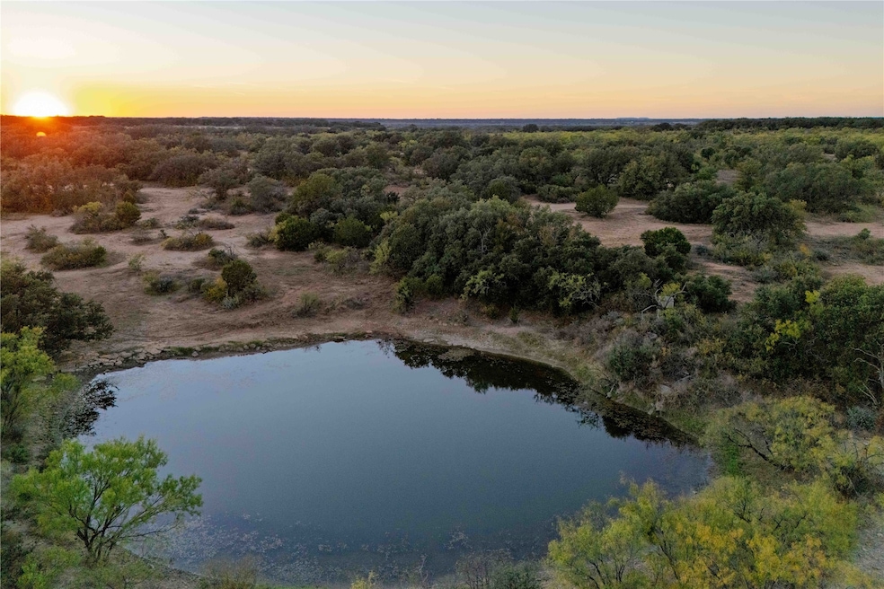
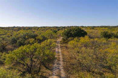
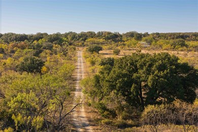
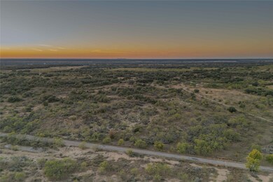
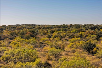
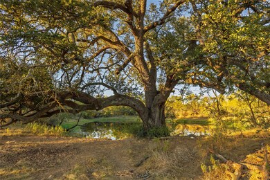
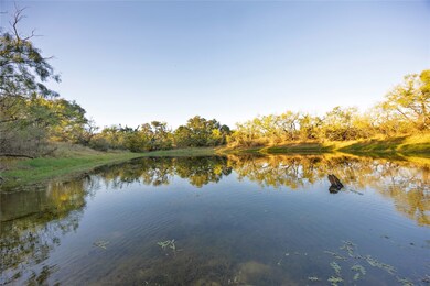
Centennial Ridge Ranch is 154.5± acres located just 8 miles southwest of Brownwood, Texas, offering convenient access to town and essential utilities already in place. The property features frontage on FM 1176 and County Road 201, providing multiple access points. The land includes water, electricity, and an on-site septic system. Improvements consist of a 20x30 metal implement barn, a 440-square-foot hunting cabin, and a 10x20 storage shed. The terrain varies by approximately 90 feet, creating a mix of open pasture, wooded cover, and elevated viewpoints providing scenic views. Three ponds stocked with channel catfish and perch enhance the property’s versatility for both recreation and wildlife management. The habitat supports whitetail deer, turkey, dove, and quail, with native vegetation such as post oak, live oak, red oak, mesquite, and bee brush providing excellent cover. A 40-acre pasture of Kline grass mixed with mesquite extends to the FM road, while the highest point of the property is a scrub oak-covered hill that serves as a bedding area for deer. This property combines rural privacy with convenient proximity to Brownwood’s amenities, making it suitable for hunting, recreation, or country living.
Listing Agent
COLTON HUTCHINS-BROKER Brokerage Phone: 325-305-0916 Listed on: 11/19/2025
Property Details
Property Type
- Land
Est. Annual Taxes
- $420
Lot Details
- 154.5 Acre Lot
- Brush Vegetation
- Lot Has A Rolling Slope
- Heavily Wooded Lot
- Many Trees
Home Design
- Ranch Property
Schools
- Northwest Elementary School
- Brownwood High School
Farming
- Agricultural
- Pasture
Listing and Financial Details
- Assessor Parcel Number 000000034377
Community Details
Overview
- Rural Subdivision
Recreation
- Pond
Map
Home Values in the Area
Average Home Value in this Area
Tax History
| Year | Tax Paid | Tax Assessment Tax Assessment Total Assessment is a certain percentage of the fair market value that is determined by local assessors to be the total taxable value of land and additions on the property. | Land | Improvement |
|---|---|---|---|---|
| 2025 | $442 | $30,690 | $0 | $0 |
| 2024 | $426 | $803,130 | $791,200 | $11,930 |
| 2023 | $435 | $29,080 | $0 | $0 |
| 2022 | $391 | $25,580 | $0 | $0 |
| 2021 | $330 | $0 | $0 | $0 |
| 2020 | $343 | $0 | $0 | $0 |
| 2019 | $333 | $0 | $0 | $0 |
| 2018 | $761 | $0 | $0 | $0 |
| 2017 | $750 | $0 | $0 | $0 |
| 2016 | $743 | $0 | $0 | $0 |
| 2015 | -- | $0 | $0 | $0 |
| 2014 | -- | $0 | $0 | $0 |
Property History
| Date | Event | Price | List to Sale | Price per Sq Ft |
|---|---|---|---|---|
| 11/19/2025 11/19/25 | For Sale | $996,525 | -- | -- |
Source: North Texas Real Estate Information Systems (NTREIS)
MLS Number: 21116338
APN: 34377
Disclaimer: Certain information contained herein is derived from information provided by parties other than Homes.com. All information provided is deemed reliable, but is not guaranteed to be accurate and should be independently verified.
![]() Listing information provided in part by the North Texas Real Estate Information Systems, Inc, for personal, non-commercial use by viewers of this site and may not be reproduced or redistributed. All information is deemed reliable but not guaranteed. Copyright © NTREIS 2025. All rights reserved
Listing information provided in part by the North Texas Real Estate Information Systems, Inc, for personal, non-commercial use by viewers of this site and may not be reproduced or redistributed. All information is deemed reliable but not guaranteed. Copyright © NTREIS 2025. All rights reserved
- 8400 Cr 201
- 7600 County Road 200
- 3995 Fm 1176
- 8675 County Road 225
- 9478 County Road 202
- TBD Cr 554, Brownwoo County Road 554
- 4879 Healer Ln
- 6342 County Road 225
- TBD County Road 225
- 10700 County Road 202
- 18200 County Road 225
- 4415 Highway 377 S
- 4415 U S Route 377
- 4322 Brookdale Dr
- 4302 Brookdale Dr
- Lot 5 Morris Sheppard Dr
- Lot 7 Morris Sheppard Dr
- Lot 8 Morris Sheppard Dr
- Lot 6 Morris Sheppard Dr
- Lot 11 Morris Sheppard Dr
- 4428 Westridge Dr
- 4235 Highway 377 S
- 2400 Mustang Dr
- 2131 Indian Creek Rd
- 2001 Slayden St
- 2801 4th St
- 2703 Southside Dr
- 2703 4th St
- 2001 Brady Ave
- 1506 3rd St Unit A
- 909 4th St
- 1102 Santa Clara Dr
- 1411 Vine St
- 601 Avenue G
- 703 Booker St Unit 705
- 401 Main St Unit 1
- 401 Main St Unit 1
- 209 N 1st St
- 1808 Springlake W
- 202 Oak St
