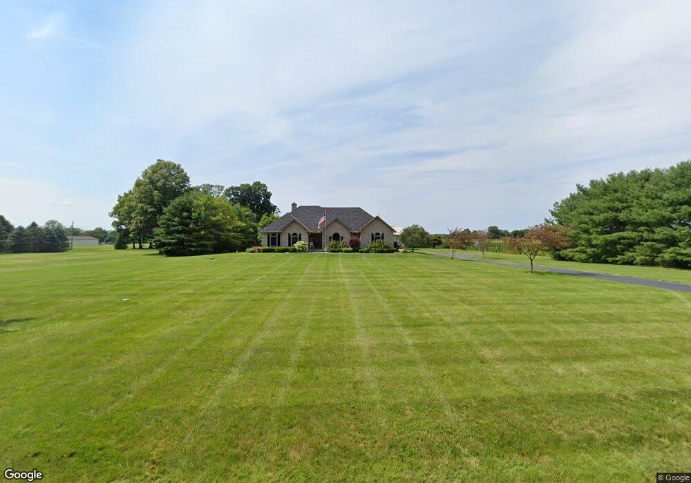
8400 Patterson Rd Hilliard, OH 43026
Brown NeighborhoodEstimated Value: $688,000 - $1,336,000
4
Beds
3
Baths
2,294
Sq Ft
$471/Sq Ft
Est. Value
About This Home
This home is located at 8400 Patterson Rd, Hilliard, OH 43026 and is currently estimated at $1,079,664, approximately $470 per square foot. 8400 Patterson Rd is a home located in Franklin County with nearby schools including Brown Elementary School, Hilliard Station Sixth Grade Elementary School, and Hilliard Memorial Middle School.
Ownership History
Date
Name
Owned For
Owner Type
Purchase Details
Closed on
Sep 9, 2021
Sold by
Sayre David C
Bought by
Rausch Jerrold W
Current Estimated Value
Purchase Details
Closed on
Jul 12, 2021
Sold by
Estate Of Teresa Lynn Sayre
Bought by
Sayre David C
Purchase Details
Closed on
Dec 4, 1986
Bought by
Sayre David C and Sayre Teresa L
Create a Home Valuation Report for This Property
The Home Valuation Report is an in-depth analysis detailing your home's value as well as a comparison with similar homes in the area
Home Values in the Area
Average Home Value in this Area
Purchase History
| Date | Buyer | Sale Price | Title Company |
|---|---|---|---|
| Rausch Jerrold W | $1,100,000 | Golden Title Agency | |
| Sayre David C | -- | None Available | |
| Sayre David C | $162,500 | -- |
Source: Public Records
Tax History
| Year | Tax Paid | Tax Assessment Tax Assessment Total Assessment is a certain percentage of the fair market value that is determined by local assessors to be the total taxable value of land and additions on the property. | Land | Improvement |
|---|---|---|---|---|
| 2025 | $10,800 | $176,720 | $38,120 | $138,600 |
| 2024 | $10,800 | $176,720 | $38,120 | $138,600 |
| 2023 | $9,491 | $210,700 | $72,100 | $138,600 |
| 2022 | $9,028 | $133,870 | $33,520 | $100,350 |
| 2021 | $12,826 | $188,940 | $88,590 | $100,350 |
| 2020 | $12,837 | $188,940 | $88,590 | $100,350 |
| 2019 | $16,785 | $210,610 | $123,390 | $87,220 |
| 2018 | $17,856 | $210,610 | $123,390 | $87,220 |
| 2017 | $16,742 | $210,610 | $123,390 | $87,220 |
| 2016 | $20,024 | $232,270 | $142,210 | $90,060 |
| 2015 | $18,967 | $232,270 | $142,210 | $90,060 |
| 2014 | $19,024 | $232,270 | $142,210 | $90,060 |
| 2013 | $6,195 | $157,664 | $71,914 | $85,750 |
Source: Public Records
Map
Nearby Homes
- 3583 Darby Knolls Blvd
- 8460 Canaan Blvd
- 8165 Lucas Rd
- 6875 Woodedge Ln
- 6793 Brookview Place
- 6801 Brookview Place
- 6754 Forest Ln
- 6784 Brookview Place
- 6825 Northfield Place
- 6824 Northfield Place
- 6745 Forest Ln
- 6737 Brookview Place
- 6721 Brookview Place
- 6704 Brookview Place
- 6897 Northfield Place
- 3780 Aviary Loop
- 3341 Woodland Dr
- 7400 Scioto Darby Creek Rd
- 1276 Four Star Dr E
- 0 Dellinger Rd Unit 9 2030113
- 8375 Patterson Rd
- 0 Patterson Rd Unit 2311572
- 0 Patterson Rd Unit 2311571
- 0 Patterson Rd Unit 2311574
- 0 Patterson Rd Unit 2311565
- 0 Patterson Rd Unit 2107280
- 0 Patterson Rd Unit 2100475
- 0 Patterson Rd Unit 79123
- 0 Patterson Rd Unit 77907
- 0 Patterson Rd Unit 76449
- 0 Patterson Rd Unit 75625
- 0 Patterson Rd Unit 75304
- 0 Patterson Rd Unit 73882
- 0 Patterson Rd Unit 9918102
- 0 Patterson Rd Unit 9831469
- 0 Patterson Rd Unit L 8 9710789
- 0 Patterson Rd Unit 2241836
- 0 Patterson Rd Unit 835807
- 0 Patterson Rd Unit 212017856
- 0 Patterson Rd Unit 222011994
Your Personal Tour Guide
Ask me questions while you tour the home.