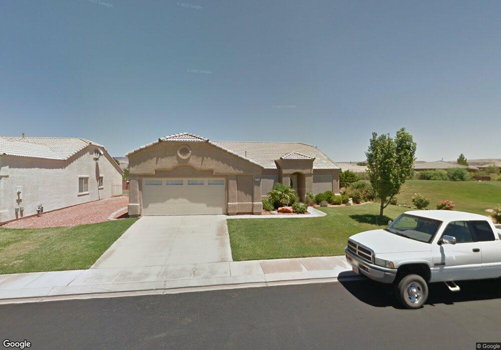
842 N 2500 W Hurricane, UT 84737
Estimated Value: $475,000 - $530,000
3
Beds
2
Baths
2,046
Sq Ft
$244/Sq Ft
Est. Value
About This Home
This home is located at 842 N 2500 W, Hurricane, UT 84737 and is currently estimated at $498,721, approximately $243 per square foot. 842 N 2500 W is a home located in Washington County with nearby schools including Hurricane Middle School, Hurricane Elementary School, and Hurricane High School.
Ownership History
Date
Name
Owned For
Owner Type
Purchase Details
Closed on
Sep 1, 2020
Sold by
White Merald and White Jeri
Bought by
Griffin Deborah and Griffin Jeffrey
Current Estimated Value
Home Financials for this Owner
Home Financials are based on the most recent Mortgage that was taken out on this home.
Original Mortgage
$323,924
Outstanding Balance
$287,989
Interest Rate
3%
Mortgage Type
FHA
Estimated Equity
$210,732
Purchase Details
Closed on
Mar 2, 2016
Sold by
Rasmussen Don Bradley and Rasmussen Kathleen K
Bought by
White Merald and White Jeri
Create a Home Valuation Report for This Property
The Home Valuation Report is an in-depth analysis detailing your home's value as well as a comparison with similar homes in the area
Home Values in the Area
Average Home Value in this Area
Purchase History
| Date | Buyer | Sale Price | Title Company |
|---|---|---|---|
| Griffin Deborah | -- | Us Title Insurance Agency | |
| White Merald | -- | Inwest Title Services |
Source: Public Records
Mortgage History
| Date | Status | Borrower | Loan Amount |
|---|---|---|---|
| Open | Griffin Deborah | $323,924 |
Source: Public Records
Tax History Compared to Growth
Tax History
| Year | Tax Paid | Tax Assessment Tax Assessment Total Assessment is a certain percentage of the fair market value that is determined by local assessors to be the total taxable value of land and additions on the property. | Land | Improvement |
|---|---|---|---|---|
| 2025 | $1,949 | $257,125 | $52,250 | $204,875 |
| 2023 | $1,883 | $252,615 | $41,250 | $211,365 |
| 2022 | $2,114 | $265,925 | $41,250 | $224,675 |
| 2021 | $3,294 | $336,700 | $55,000 | $281,700 |
| 2020 | $1,676 | $291,200 | $50,000 | $241,200 |
| 2019 | $1,530 | $257,800 | $50,000 | $207,800 |
| 2018 | $1,466 | $127,105 | $0 | $0 |
| 2017 | $1,494 | $124,575 | $0 | $0 |
| 2016 | $1,443 | $116,545 | $0 | $0 |
| 2015 | $2,445 | $190,200 | $0 | $0 |
| 2014 | $2,179 | $176,300 | $0 | $0 |
Source: Public Records
Map
Nearby Homes
- 839 N 2500 W
- 2406 W 750 N
- 2364 W 1050 N
- 2354 1050 N
- 2287 W 1050 N
- 0 Unit 25-265624
- 519 N 2480 W
- 501 N 2480 W
- Sierra Nevada Plan at Eagle Pointe At The Front Nine
- Kilauea Plan at Eagle Pointe At The Front Nine
- Olympic 2 Plan at Eagle Pointe At The Front Nine
- Kenai Plan at Eagle Pointe At The Front Nine
- Mauna Loa 2 Plan at Eagle Pointe At The Front Nine
- Kilauea 2 Plan at Eagle Pointe At The Front Nine
- Pine Valley Plan at Eagle Pointe At The Front Nine
- Timpanogos Plan at Eagle Pointe At The Front Nine
- Uinta Plan at Eagle Pointe At The Front Nine
- Mt. Columbus Plan at Eagle Pointe At The Front Nine
- 0 the Back Nine at Sky Mountain Unit 25-264908
- 2684 W 625 N